Democratizing the production and consumption of information
Home   Free GIS   Free Shapefiles   Free Maps   Toxic Risk   Google Earth   Learn GIS   Climate Change   About

Electronic & Computer Recycling, Deconstruction & Building Material Salvage... Learn More

A Member of the
Reimagination Network

Didn't find what you are looking for? Email me and I'll find it for you.

Free Newsletter
Signup for updates and additions.

Have a question or comment? Post them at the MapCruzin Blog.

Download Census 2008
Tiger/Line ArcGIS Shapefiles

Free Tiger files now available for download in ESRI shapefile format.

Indian & Federal Lands - Maps in shapfile format.

Reimagination - Alternative resources for Today and Tomorrow.

Climate Change Maps

GPS Global Positioning

Free World Regional Maps - high resolution JPG and PDF downloads

Free TOPO and
Terrain Maps

USGS Digital Raster Graphic (DRG) Topographic Maps, Satellite and more.

Arctic National Wildlife Refuge Maps

Google Earth & Maps Resources & Tools

GIS Maps of Africa

GIS Maps of Ecosystems

Environmental GIS Maps

Wireless Maps - cellular

Historical Maps

MrSid, JPEG2000 & TIFF

Health & GIS

GIS Tutorials

GIS Mapping Resources

Census Data & Maps

Digital Data & Maps

Toxic Release Maps

GIS Explained

Featured

Home Based Recycling Business - Free resources and tools.

Reimagination - Reimagining, exploring and celebrating the changes in infrastructure, politics and culture that will help us live in harmony with each other and the earth now and in the future.

Toxic Klamath River

Arctic National Wildlife Refuge

Democracy at Risk: California Secretary of State Debra Bowen's report Top To Bottom Review finds that electronic voting machines supplied by several vendors are subject to hacking and inaccuracies.

Climate Shift - The effects of climate shift on the future of planet earth and its inhabitants.

Right to Know or Left to Wonder?

Shrubbed

Terrorspeak

Soaring Cancer Rates Blamed On Chemicals: Epidemic is Preventable. New report from CCPA.

21st Century Warfare

Hazardscapes - Toxic and Nuclear Risks in your backyard.

War & Environment

Worst Case Scenarios: Terrorism & industrial chemicals.

Redwood Ecotours: Explore California's Redwood North Coast.


progressive news view and books

poets against the war

Journal of composting and organics recycling

Viewable with ANY browser


Partners

SocioDemographics.com
Learn2map.com
Reimagination.com
RedwoodEcotours.com
NorthCoastGis.com
RecyclingSecrets.com
ClimateInjustice.com
bluecreekahpah.org
ClimateShift.com
ToxicRisk.com
MichaelMeuser.com
MorgellonsMaps.com

Radiofrequency, Wireless, Cell Phone and EMF Risks

Cell Towers mapped with Google Earth.

New Additions (archives)

Powerwatch is a non-profit independent organisation with a central role in the UK Electromagnetic Field and Microwave Radiation health debate. We work closely with decision-makers in government and business, and with other like-minded groups, promoting policies for a safer environment. We have been researching electromagnetic field effects on health for the last 20 years, and provide a range of information to help the general public understand this complex issue.

Click here for free map archives Mast Sanity is the primary national organisation opposing the insensitive siting of mobile phone and Tetra masts in the UK. We offer timely advice and support to local campaigns and aim to provide that information "one stop shop" that all new mast campaigners need.

Maps of cell towers anywhere in U.S. (Seems to work best with Internet Explorer).

Archives

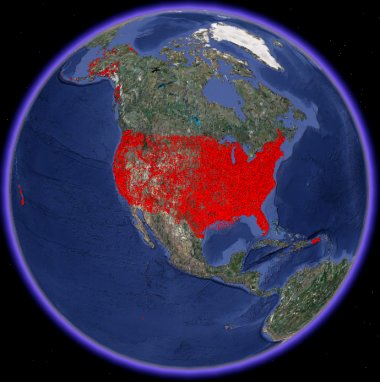
Cell Tower & Wireless Maps - 
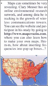
To the left is a mention of our work from the February, 2002 issue of Monitoring Times magazine.
We provide AM, FM, Cellular, Antenna Structure Registration, Land Mobile, Pager, Microwave and TV antenna and tower data and information at the county level for the entire U.S.
We make this available for your use in several forms including: Excel spread- sheets, geospatial map layers that you can use with Arcview and many other GIS programs including the free GIS, ArcExplorer (see our
Learn2map Tutorial & Atlas for more about obtaining and using ArcExplorer.
We also provide complete turnkey internet-ready web-map projects. Web-maps enable your website so that visitors can see the wireless sites on a map, zoom-in, move around within the maps and click on any particular site to obtain more information. This is a great way to help your community become more involved in and knowledgeable about your local wireless siting issues. Contact us for more information.

Click here for free map archives


On This Page --> Maps, Research Papers, News & Articles, Resources

Map of U.S. Radiofrequency Towers and Antennas. This is a simple project that maps various wireless RF sources including cell, pagers, TV, AM, FM, and microwave antennas and towers in the U.S. -- Striking patterns and density. Interested in researching and mapping the sources in your community? Contact me for more information (For ideas, see our pilot project of Inkom, Idaho).

U.S. Electrical Power Distribution Network. This is a single map that shows the major U.S. electrical power distribution network. Interested in researching and mapping the sources in your community? Contact me for more information.

News & Articles

An Evaluation of the Possible Risks From Electric and Magnetic Fields (EMFs) From Power Lines, Internal Wiring, Electrical Occupations and Appliances, California Department of Health Services, California EMF Program.

Spray-on Antennas Make Their Mark (07/11)

IGEF-expert won case against mobile communications company (07/10)

Cell phone industry faces legal tests (07/04)

Cover-up about cell phone danger By Martin Schram (06/15)

Static intensifies over plans to erect tower in River Vale (06/01)

West Milford faces new battle over cell towers (06/01)

Meeting of the Minds - The cell phone industry wants you to believe their product is proven safe; like many things in life, it's not quite that simple ... (?/01)

Mobile firms patent cancer shields (06/01)

How cell phones can cause cancer (06/01)

Federal GAO Report Does Not Rule Out Cell Phone Dangers (05/01)

The consensus of the Food and Drug Administration (FDA), the World Health Organization, and other major health agencies is that the research to date does not show radiofrequency energy emitted from mobile phones has harmful health effects, but there is not yet enough information to conclude that they pose no risk (05/01)

School tells Sprint to pull its cell tower (05/01)

Let's change plan for Maryland tower (02/01)

Resident battles cell phone towers (11/00)

U.K. consumer group: Hands-free phone kits boost radiation exposure (11/00)

Wireless Worries? (10/00)

Heads turning to cell phone dangers (04/00)

Cell towers vs. birds - Spread of transmitters worries Heron protectors (12/99)

Cell phone nightmare (11/99)

Cell Phone Technology Killing Songbirds, Too (11/99)

Cell phone fears (11/99)

Cash Comes Calling As churches rent space for cel phone towers (08/99)

Cellphones - A Boon To Modern Society Or A Threat To Human Health? (01/99)

Cellphones - A Boon To Modern Society Or A Threat To Human Health? - Part 2 (01/99)

Cell-Phone Towers and Communities: The Struggle for Local Control (10/98)

The Electromagnetic Radiation Health Threat - Part I (08/97)

The Electromagnetic Radiation Health Threat - Part II (08/97)

Schools, cities cash in on cell tower boom (05/97)

Cell Phones Cancer Connection (04/97)

Research

Short Blurb from HowStuff Works "how cell phone radiation works."

Neurological Effects of Radiofrequency Electromagnetic Radiation Relating to Wireless Communication Technology by Dr. Henry Lai. Presented at the IBC-UK Conference: "Mobile Phones - Is there a Health Risk?" September 16-17, 1997 in Brussels, Belgium.

Health effects associated with mobile base stations in communities: the need for health studies by Dr. Neil Cherry.

Neurological Effects of Radiofrequency Electromagnetic Radiation by Dr. Henry Lai. Presented at the "Workshop on Possible Biological and Health Effects of RF Electromagnetic Fields", Mobile Phone and Health Symposium, Oct 25-28, 1998, University of Vienna, Vienna, Austria.

Resources

Cell Tower Maps. (Seems to work best with Internet Explorer).

Cell-Out

Toxic Electricity

Council on Wireless Technology Impacts

Electric-Words - Telecommunications - Cellphones - Health - History - Politics - Economics -- The extraordinary site of Stewart Fist, journalist, columnist, and film-maker.

PUBLIC EXPOSURE: DNA, Democracy & the Wireless "Revolution"

Parents Against Leukemia

Sprint Off Schools! news items

Some Not~So~Fun Facts About the Physics of Cell Phones (6/00)

Tower Talk State-by-State Tower Reports

RCR Wireless News

Independent Expert Group on Mobile Phones. Their report, "Mobile Phones and Health" is available for download in PDF format.

Report on the Potential Health Risks of Radiofrequency Fields from Wireless Telecommunication Devices

Telecommunications Act of 1996

Radio Frequency Radiation Nation - Simple maps showing the distribution of towers and antennas in the U.S.

Community Perspectives on Sutro Tower

The EMR Network

EMF/RFR Bioeffects and Public Policy

Best,


MapCruzin.com is an independent firm
specializing in the publication of
educational and research resources.
We created the first U.S. based
interactive toxic chemical facility
maps on the internet in 1996 and we
have been online ever since. View
some of our projects.

Contact Us

Custom Search

FREE: Renewable Energy Potential Maps - Oil & Gas Field Energy Shapefile and PDF Maps - Toxic Risks, Neighborhoods & Schools Maps - Residential Energy Consumption Maps - Free Map Downloads - GIS Software - GPS Resources and Tutorials - Google Earth and Google Maps mashups, resources, maps and tools - Data - Learn2Map GIS Tutorial and Atlas - ANWR Caribou Maps - Satellite Aerial Photos - ArcGIS shapefiles - Pollution Maps - Climate Maps - H1N1 Swine Flu Maps - 2008 Tiger Shapfiles - State GIS Shapefiles - National Park, Monument, Historic Site Maps - World ArcGIS Shapefiles - International Maps - Historical Maps - TOPO Maps - U.S. Boundary Shapefiles - Toxic Maps with Google - Extreme Weather & Disaster Maps - Oil & Gas Maps - Cell Tower Maps - U.S. State GIS Resources

MapCruzin Blog for updates, questions and answers

Blog Updates

More Blog Updates

We'll send feeds to you
Enter your email address

Delivered by FeedBurner

MapCruzin Consulting
GIS and Google Maps Development, Website Creation and Hosting, Fast and Affordable.

Follow Mapcruzin.com on Twitter
Follow on Twitter

2007 TRI Toxic Release Inventory and School Google Maps
TOXICS AND Children's Health - Learn more about the toxic chemical risks near your schools and in your backyards. Latest 2007 Toxic Release Inventory TRI (released 03/19/2009) and schools with Google Maps and searchable EPA Risk Management Plan database.

Toxic Chemical Pollution, Schools & Children's Health News

Download Free H1N1 Swine Flu ArcGIS Shapefiles and Data.

News

Obama's New EPA
EPA Halts Hundreds of Mountaintop Mining Permits
EPA tells White House CO2 is a pollutant
New Toxic Release Data Available
EPA Proposes First National Reporting on Greenhouse Gas Emissions

Downloads

Google Earth Toxic Release Inventory (TRI) Maps
Lester Brown's Plan B 3.0
State GIS Shapefiles, Maps & Resources
GIS Shapefiles & Maps
GIS Programs, Tools & Resources
Free World Country & Regional Maps
GIS / GPS Careers and Job Positions
Disease Outbreak Maps
TOPO Maps
Extreme Weather & Disaster Maps
Free World Maps from the CIA Factbook
Arctic National Wildlife Refuge ANWR Maps
Oil and Gas Maps
Africanized Honey Bees
Renewable Energy Potential Maps of the United States
Terrorism Maps
War Maps
Google Maps
Weather Maps
GPS Resources
Historical Maps of the World
Google Earth
Library of Congress American Memory Map Downloads
Toxic Chemical Pollution Maps
Climate Change Maps
Toxic Release Inventory (TRI) Maps
Census Shapefiles
World Maps

Issues

Environmental Justice
Data Sources
Greenwash & JunkScience
Statistical Resources
Wireless Dangers
Surviving Climate Change
Global Right-To-Know
Creating Living Economies
Books of Note
Toxic Klamath River
Federal Lands Maps
TRI Analysis
TRI Webmaps
EnviroRisk Map Network
Community-Based Research
Right-To-Know or Left to Wonder?
Chemical Industry Archives
21st Century Warfare
Biotechnology
Nanotechnology
Globalization/Democracy
Shrubbed
National Parks and Public Lands
Trade Secrets/Toxic Deception
GIS Books
Our Projects
Other Projects
1999 Archive Environews
Environmental Books
Environmental Links
Redwood Coast Information
Recycle, Salvage, Reuse

Resources

FREE STUFF

Free World Regional Maps - high resolution JPG and PDF downloads

Free TOPO and
Terrain Maps

USGS Digital Raster Graphic (DRG) Topographic Maps, Satellite and more.

Arctic National Wildlife Refuge Maps

Google Earth & Maps Resources & Tools

GIS Maps of Africa

GIS Maps of Ecosystems

Environmental GIS Maps

GPS Global Positioning

Wireless Maps - cellular

Historical Maps

Health & GIS

GIS Tutorials

GIS Mapping Resources

Census Data & Maps

Digital Data & Maps

Toxic Release Maps

Climate Change Maps

GIS Explained

Privacy, Fair Use and Disclaimer - Advertise on MapCruzin.com

Home | Free GIS | Downloads | Parks & Public Lands | Books | Environmental Justice | News Archives
Free GIS Tutorial | Consulting | TRI 2004 MAPS | Recycle Reuse Business | Toxics Explorer
North Coast GIS | Contact/About Us | Redwood Ecotours | Global Positioning | EnviroRisk Map Network
Climate Collapse | Free GIS Tutorial | What is GIS? | Right to Know | Reimagination | Health & GIS | Shrubbed | Search

Questions, Comments or Suggestions? Contact Us

Website development and hosting provided by the Reimagination Network

Copyright © 1996 - 2009 Reimagination Network, All Rights Reserved
MapCruzin is a Pop-Up Free Website -- Best Viewed With ANY Browser