Independent publisher of research and educational resources
Home   Free GIS   Free Shapefiles   Free Maps   News   TOPO   Google Maps   Energy   Satellite   GPS   Learn GIS   BLOG

Subscribe for updates,
feeds, and newsletter
Enter your email address:

Delivered by FeedBurner

Indian and Federal Lands Shapefiles - Indian Lands, National Park Service, U.S. Forest Service, Bureau of Land Managment ... more

Follow Mapcruzin.com on Twitter
Follow on Twitter

A Member of the
Reimagination Network

Didn't find what you are looking for? Email me and I'll find it for you.

Have a question or comment? Post them at the MapCruzin Blog.

Climate Shift Blog

Recycling Secrets Blog

GIS Tutorials

GIS Basics

GIS Terminology

Mapcruzin Free GIS Tools, Resources, News and Maps

Of Interest

Home Based Recycling Business - Free resources and tools.

Reimagination - Reimagining, exploring and celebrating the changes in infrastructure, politics and culture that will help us live in harmony with each other and the earth now and in the future.

Arctic National Wildlife Refuge

Climate Shift - The effects of climate shift on the future of planet earth and its inhabitants.

Right to Know or Left to Wonder?

Shrubbed

Terrorspeak

21st Century Warfare

Hazardscapes - Toxic and Nuclear Risks in your backyard.

War & Environment

Worst Case Scenarios: Terrorism & industrial chemicals.

Redwood Ecotours: Explore California's Redwood North Coast.


poets against the war

World View of Global Warming

Viewable with ANY browser


Download Oil and Gas Maps

<-- Return to main Free Maps Download Page

World - Crude Oil Seaborne Trade 1994 (IMO) [PDF]

World - Oil Reserves (Energy Bulletin)

World - Oil Reserves (The Independent)

Africa - Geology, Oil and Gas Fields - Clickable Map (USGS)

Arabian Peninsula Geology, Oil and Gas Fields - Clickable Map (USGS)

Arctic - Geology, Oil and Gas Fields (USGS)

Asia - East - Geology, Oil and Gas Fields - Clickable Map (USGS)

Asia - South - Geology, Oil and Gas Fields - Clickable Map (USGS)

Asia - Southeast - Geology, Oil and Gas Fields - Clickable Map (USGS)

Australia and New Zealand - Geology, Oil and Gas Fields - Clickable Map (USGS)

Australia - Oil and Gas Pipelines (Pipeliner.com)

Australia, Western - Energy Map (Office of Energy) [PDF]

Barents Sea Region - Oil and Gas Development and Seabird Colonies (UNEP/GRID)

Canada - Alberta Oil Sands (Alberta Geological Society)

Canada - Alberta Oil Sands Lease Map (Canadian Oil Sands Trust)

Canada - British Columbia Petroleum Finder Map

Canada - British Columbia Offshore Petroleum Maps (B.C. Ministry of Energy and Mines)

Caspian Region Oil Pipelines, U.S. Central Intelligence Agency, April 2002 (PCL Map Collection) (633K) [PDF]

[Caspian Region] Oil and Gas Infrastructure in the Caspian Sea Region, CIA, March 2001 (PCL Map Collection) (2.5 MB)

China - Geology, Oil and Gas Fields - Clickable Map (USGS)

Europe - Crude Oil Pipelines (INOGATE)

Europe - Existing and Planned Natural Gas Pipelines to Europe (PCL Map Collection) from U.S. Energy Information Administration, Country Analysis Briefs, Major Russian Oil and Natural Gas Pipeline Projects, March 2005 (183K)

Europe - Geology, Oil and Gas Fields (USGS)

Europe - Natural Gas Pipelines (INOGATE)

Greece-Italy Gas Pipeline (Edison)

India - BG India Operations Map (BG India)

India - Energy Map from "India: An Energy Sector Overview", 1997, U.S. Energy Information Administration (PCL Map Collection) (55K)

India - Geology, Oil and Gas Fields - Clickable Map (USGS)

Iran - Geology, Oil and Gas Fields (USGS)

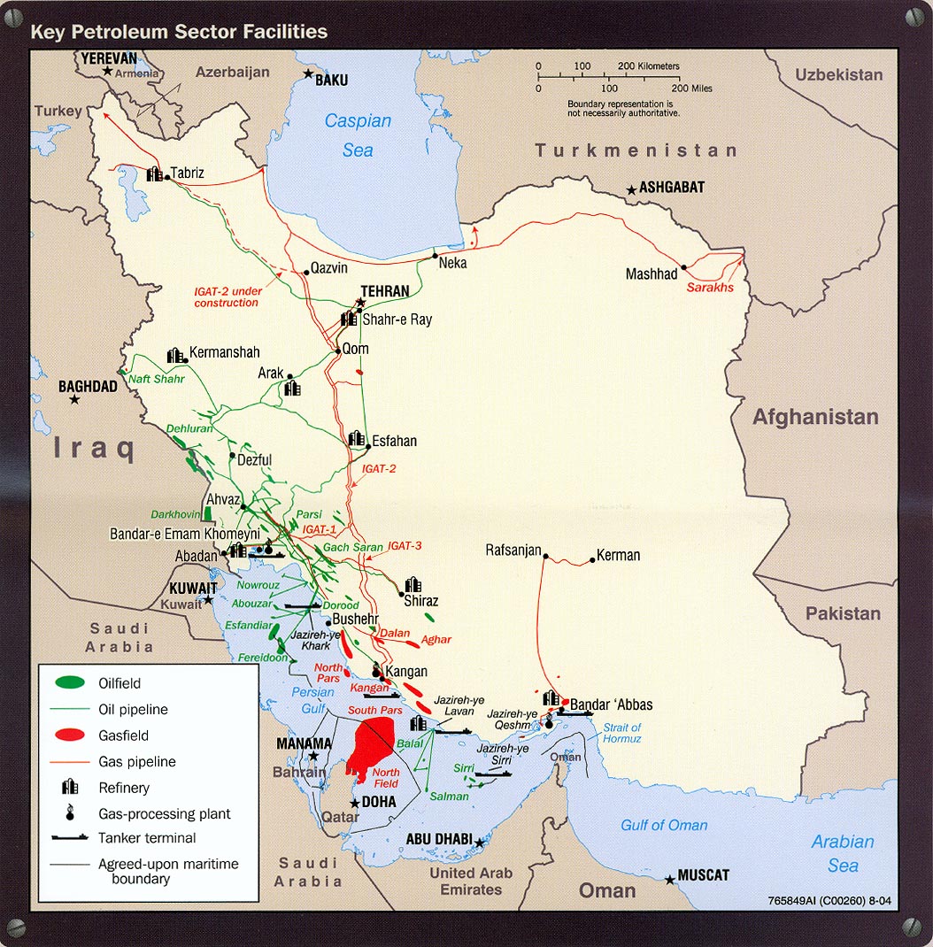
Iran - Key Petroleum Sector Facilities, portion of Iran Country Profile 2004, U.S. Central Intelligence Agency (PCL Map Collection) (318K)

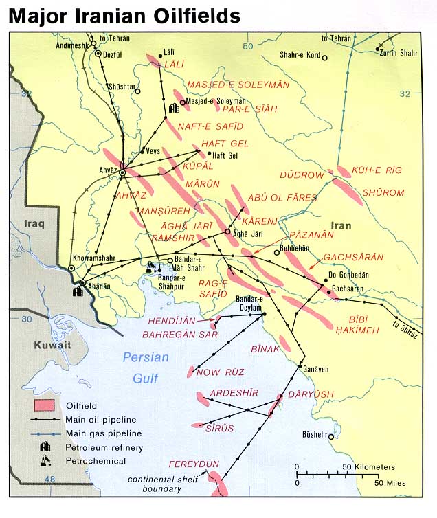
Iran - Major Iranian Oilfields from U.S. Central Intelligence Agency map of Iran, 1978 (PCL Map Collection) (108K)

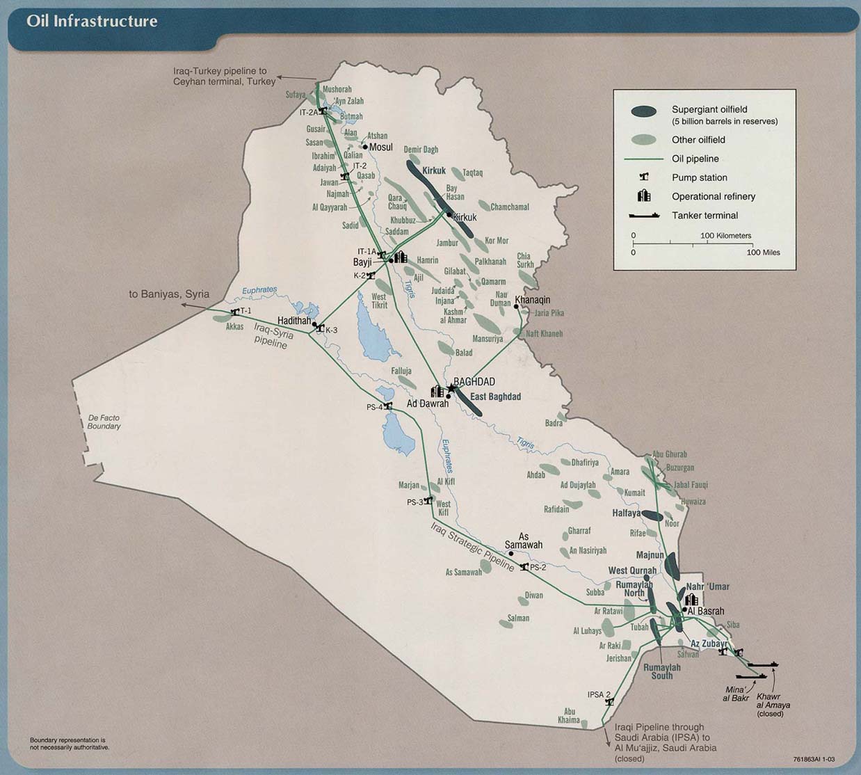
Iraq - Oil Infrastructure From Iraq: Country Profile [map], CIA (PCL Map Collection), January 2003 (157K) and pdf format (160K)

Iraq - Pipelines (Jerusalem Post)

Kazakhstan - Proposed Pipeline to China, July 2004, Central Intelligence Agency (PCL Map Collection) (898K) [PDF]

Kuwait - Oil Fields (MERIP)

New Zealand and Australia - Geology, Oil and Gas Fields - Clickable Map (USGS)

New Zealand - Petroleum Permit Maps (Ministry of Economic Development)

Nigeria - Niger Delta Petroleum System (USGS)

Norway - Norwegian Continental Shelf Energy Map (Aftenbladet)

Romania - Natural Gas Grid (Balkanenergy)

Russia - Geology, Oil and Gas Fields - Clickable Map (USGS)

Russia - Pipelines (BBC News)

[Russia to Europe] Existing and Planned Natural Gas Pipelines to Europe (PCL Map Collection) from U.S. Energy Information Administration, Country Analysis Briefs, Major Russian Oil and Natural Gas Pipeline Projects, March 2005 (183K)

Russia to Europe - Gas Pipelines (Centre for Eastern Studies)

South America - Geology, Oil and Gas Fields (USGS)

Ukraine Gas Pipelines (Eurotrib)

U.S. - Gas Price Map (GasBuddy)

U.S. - Alaska - Prudhoe Bay Map (Chubb Custom Cartography)

U.S. - Appalachian Region Oil and Gas Data Viewer (PTTC)

U.S. - New Mexico - Oil and Gas Wells Map Viewer (Go-Tech)

U.S. - Michigan - Petroleum and Natural Gas Maps (Michigan Public Service Commission)

U.S. - Natural Gas Pipeline Network (U.S. Energy Information Administration)

U.S. - Permian Basin (University of Texas, Bureau of Economic Geology)

U.S. - Texas Offshore Oil and Gas Divisions (Texas Railroad Commission) [PDF]

U.S. - Texas - Oil and Gas Maps (Railroad Commission of Texas)

U.S. - Utah - Geologic Resource Maps (Utah Geolgical Survey)

U.S. - Utah Oil and Gas Well Map Search (State of Utah, Division of Oil, Gas and Mining)

U.S. - Wyoming, Utah, Colorado - Oil Shale and Tar Sands Maps (OSTSEIS

About Quality, Accuracy and Suitability

These GIS software tools, programs and resources come from a variety of U.S. government and private sources. While we try to assure the accuracy of this material, we cannot promise that it is absolutely accurate. We do promise that using what you find here will be fun, entertaining or educational - perhaps even frustrating. Beyond this, we make no guarantee as to its suitability for any purpose. We assume no liability or responsibility for errors or inaccuracies. Please understand that you use these tools, programs and resources at your own risk.

Thanks,


MapCruzin.com is an independent firm specializing in the publication of educational and research resources. We created the first U.S. based interactive toxic chemical facility maps on the internet in 1996 and we have been online ever since. Learn more about us and view some of our projects and services.

Contact Us

Report Broken Links

Didn't find what you are looking for? We've been online since 1996 and have created 1000's of pages. Search below and you may find just what you are looking for.

Bookmark and Share

MapCruzin Blog for updates, questions and answers

Blog Updates

More Blog Updates

Most Popular:
Renewable Energy Shapefiles, Oil & Gas Field Energy, Renewable Energy Potential Maps, Residential Energy Consumption Maps, 2009 Tiger Line Shapefiles, World Energy Maps, Haiti Earthquake Maps & Resources, Orbit Free GIS for Mac OSX, Win 32 & 64, Unix, FCC Wireless Licensing and Market Boundary Shapefiles, TRI National Analysis Data, Shapefiles, U.S. State ArcGIS Shapefiles, Afghanistan ArcGIS Shapefiles, Free GIS & Geospatial Software, Afghanistan Maps, Natural Disaster ArcGIS Shapefiles, U.S. State Maps, Satellite & Aerial Photos, Health Uninsured Maps, Climate Change, Cell Phone Health, Towers, Maps, Chemical Terrorism, Transportation Shapefiles, Toxics, Chemicals, Schools, Google Earth & Maps, Indian & Federal Lands Shapefiles, Arctic National Wildlife Refuge Maps, Economy Maps, TOPO Maps, MapCruzin Blog

Free Shapefiles:
New Additions
FCC Wireless Licensing and Market Boundary Shapefiles, TRI National Analysis Data, Shapefiles, U.S. State ArcGIS Shapefiles, Afghanistan ArcGIS Shapefiles, Natural Disaster ArcGIS Shapefiles, Renewable Wind Energy Shapefiles, EPA Criteria Pollutant Shapefiles, North American Transportation Shapefiles, 2009 Tiger Line, State GIS, World Country ArcGIS, U.S. State GIS Resources, Climate Maps, Canada, Mexico, U.S. Transportation, ArcGIS shapefiles, Neighborhood Boundary, Satellite Aerial
Oil & Gas Field Energy, Toxic Risks, Neighborhoods & Schools, EPA Geospatial, U.S. Boundary Shapefiles, H1N1 Swine Flu, EPA TRI Toxic Release Inventory, Pollution Maps

Partners
Climate Shift, Recycle, Reuse & Salvage, TerraKnowledge.net, Climate Injustice, Pollution Map Projects, News & Resources, Blue Creek - Ah Pah, Right Livelihoods, Reimagination, Redwood Ecotours

Can we do a project for you?

MapCruzin Consulting
GIS and Google Maps Development, Website Creation and Hosting, Fast and Affordable.

Downloads

Google Earth Toxic Release Inventory (TRI) Maps
Lester Brown's Plan B 3.0
State GIS Shapefiles, Maps & Resources
GIS Shapefiles & Maps
GIS Programs, Tools & Resources
Free World Country & Regional Maps
GIS / GPS Careers and Job Positions
Disease Outbreak Maps
TOPO Maps
Extreme Weather & Disaster Maps
Free World Maps from the CIA Factbook
Arctic National Wildlife Refuge ANWR Maps
Oil and Gas Maps
Africanized Honey Bees
Renewable Energy Potential Maps of the United States
Terrorism Maps
War Maps
Google Maps
Weather Maps
GPS Resources
Historical Maps of the World
Google Earth
Library of Congress American Memory Map Downloads
Toxic Chemical Pollution Maps
Climate Change Maps
Toxic Release Inventory (TRI) Maps
Census Shapefiles
World Maps

Issues

Environmental Justice
Data Sources
Greenwash & JunkScience
Statistical Resources
Wireless Dangers
Surviving Climate Change
Global Right-To-Know
Creating Living Economies
Books of Note
Toxic Klamath River
Federal Lands Maps
TRI Analysis
TRI Webmaps
EnviroRisk Map Network
Community-Based Research
Right-To-Know or Left to Wonder?
Chemical Industry Archives
21st Century Warfare
Biotechnology
Nanotechnology
Globalization/Democracy
Shrubbed
National Parks and Public Lands
Trade Secrets/Toxic Deception
GIS Books
Our Projects
Other Projects
1999 Archive Environews
Environmental Books
Environmental Links
Redwood Coast Information
Recycle, Salvage, Reuse

Resources

Environmental Book Discounts
Korten - Speth - Bullard
Environmental Justice
Hawken - Climate Change
Peak Oil - Alternative
Energy - Nuclear Risk
Water Crisis - Food Crisis
Energy Crisis - Housing
Crisis

GIS Book Discounts
GIS - GPS - Remote
Sensing - Google Maps
Cartography - Geography
Maps - Google Earth

About MapCruzin - Privacy, Fair Use and Disclaimer - Advertise on MapCruzin.com

Home | Free GIS | Downloads | Parks & Public Lands | Books | Environmental Justice | News Archives
Free GIS Tutorial | Consulting | TRI 2004 MAPS | Recycle Reuse Business | Toxics Explorer
North Coast GIS | Contact/About Us | Redwood Ecotours | Global Positioning | EnviroRisk Map Network
Climate Collapse | Free GIS Tutorial | What is GIS? | Right to Know | Reimagination | Health & GIS | Shrubbed | Search

Questions, Comments or Suggestions? Contact Us

Website development and hosting provided by the Reimagination Network

Copyright © 1996 - 2010 Reimagination Network, All Rights Reserved
MapCruzin is a Pop-Up Free Website -- Best Viewed With ANY Browser