|
<-- Return to Do It Yourself GIS Maps
 U.S. Geographic Names Information System (GNIS) Shapefiles Based on USGS GNIS Data
 These ArcGIS shapefiles work with the free ArcExplorer GIS viewer, ArcView GIS, ArcGIS, Maptitude, Mapinfo, Manifold, TatukGIS and many other commercial GIS and mapping programs and many free GIS programs as well and they're much less costly than most others. Use our free Learn2Map GIS Tutorial and Atlas to add streets, highways, census information and much more to your maps for free. We have included free national level base maps with each map archive listed below. Also, check our free GIS software and free GIS ArcGIS shapefiles pages for more information and free ArcGIS shapefiles. If you are new to GIS, check out our free Learn2Map GIS Tutorial and Atlas.
Shapefile Description
These shapefiles are derived from the latest October 1, 2012 update of the USGS Geographic Names Information System (GNIS) Dataset. Specifically the shapefiles below are based on the data contained in NationalFile_20121001.zip available from the USGS Geographic Names Information System website. Detailed information about the GNIS is available from USGS. The following 64 GNIS shapefiles contain a total of 2,176,280 records (data points). You can view and download the metadata here.
The GNIS is the official vehicle for geographic names use by the Federal Government and the source for applying geographic names to Federal maps & other printed and electronic products. The system supports the U.S. Board on Geographic Names, a Federal body created in 1890 and established in its present form by Public Law in 1947. The Board serves the Federal Government, other government agencies, and the public as the central authority to which name inquiries, name issues, and new name proposals may be directed.
The GNIS provides names data to government agencies and to the public, provides the Geographic Names data layers to The National Map, and is the source for the gazetteer (Find Place) search in The National Map viewer. Web map and features services for names data also are available.
Save! The cost for each shapefile is $39. If you are purchasing more than 10 of these shapefiles, consider purchasing all 64 GNIS shapefiles for $499 total saving hundreds of dollars.
Immediate Download
Shapefiles on this page: Airport,
Arch,
Area,
Arroyo,
Bar,
Bay,
Beach,
Bench,
Bend,
Bridge,
Building,
Canal,
Cape,
Cemetery,
Census,
Channel,
Church,
Civil,
Cliff,
Crater,
Crossing,
Dam,
Falls,
Flat,
Forest,
Gap,
Glacier,
Gut,
Harbor,
Hospital,
Island,
Isthmus,
Lake,
Lava,
Levee,
Locale,
Military,
Mine,
Oilfield,
Park,
Pillar,
Plain,
Populated Place,
Post Office,
Range,
Rapids,
Reserve,
Reservoir,
Ridge,
School,
Sea,
Slope,
Spring,
Stream,
Summit,
Swamp,
Tower,
Trail,
Tunnel,
Valley,
Well,
Woods,
All
Click next to the shapefile you wish and you will have immediate access to it using our secure merchant account provider, ClickBank/Keynetics or PayPal, whichever you prefer.
GNIS Airport GIS Shapefile, 23,019 records Download Now
GNIS Arch GIS Shapefile, 708 records Download Now
GNIS Area GIS Shapefile, 2,369 records Download Now
GNIS Arroyo GIS Shapefile, 460 records Download Now
GNIS Bar GIS Shapefile, 5,893 records Download Now
GNIS Basin GIS Shapefile, 4,291 records Download Now
GNIS Bay GIS Shapefile, 13,009 records Download Now
GNIS Beach GIS, 2,397 records Download Now
GNIS Bench GIS Shapefile, 722 records Download Now
GNIS Bend GIS Shapefile, 2,813 records Download Now
GNIS Bridge GIS Shapefile, 7,207 records Download Now
GNIS Building GIS Shapefile, 137,384 records Download Now
GNIS Canal GIS Shapefile, 21,466 records Download Now
GNIS Cape GIS Shapefile, 16,389 records Download Now
GNIS Cemetery GIS Shapefile, 132,733 records Download Now
GNIS Census GIS Shapefile, 17,324 records Download Now
GNIS Channel GIS Shapefile, 4,111 records Download Now
GNIS Church GIS Shapefile, 237,661 records Download Now
GNIS Civil GIS Shapefile, 57,837 records Download Now
GNIS Cliff GIS Shapefile, 4,445 records Download Now
GNIS Crater GIS Shapefile, 240 records Download Now
GNIS Crossing GIS Shapefile, 13,100 records Download Now
GNIS Dam GIS Shapefile, 57,204 records Download Now
GNIS Falls GIS Shapefile, 2,472 records Download Now
GNIS Flat GIS Shapefile, 10,461 records Download Now
GNIS Forest GIS Shapefile, 1,300 records Download Now
GNIS Gap GIS Shapefile, 8,397 records Download Now
GNIS Glacier GIS Shapefile, 1,021 records Download Now
GNIS Gut GIS Shapefile, 3,948 records Download Now
GNIS Harbor GIS Shapefile, 1,274 records Download Now
GNIS Hospital GIS Shapefile, 15,562 records Download Now
GNIS Island GIS Shapefile, 20,345 records Download Now
GNIS Isthmus GIS Shapefile, 28 records Download Now
GNIS Lake GIS Shapefile, 69,251 records Download Now
GNIS Lava GIS Shapefile, 170 records Download Now
GNIS Levee GIS Shapefile, 541 records Download Now
GNIS Locale GIS Shapefile, 157,103 records Download Now
GNIS Military GIS Shapefile, 2,636 records Download Now
GNIS Mine GIS Shapefile, 34,379 records Download Now
GNIS Oilfield GIS Shapefile, 4,862 records Download Now
GNIS Park GIS Shapefile, 67,762 records Download Now
GNIS Pillar GIS Shapefile, 2,054 records Download Now
GNIS Plain GIS Shapefile, 282 records Download Now
GNIS Populated Place GIS Shapefile, 193,701 records Download Now
GNIS Post Office GIS Shapefile, 32,328 records Download Now
GNIS Range GIS Shapefile, 2,457 records Download Now
GNIS Rapids GIS Shapefile, 1,103 records Download Now
GNIS Reserve GIS Shapefile, 1,093 records Download Now
GNIS Reservoir GIS Shapefile, 75,024 records Download Now
GNIS Ridge GIS Shapefile, 15,096 records Download Now
GNIS School GIS Shapefile, 206,887 records Download Now
GNIS Sea GIS Shapefile, 14 records Download Now
GNIS Slope GIS Shapefile, 370 records Download Now
GNIS Spring GIS Shapefile, 36,104 records Download Now
GNIS Stream GIS Shapefile, 230,689 records Download Now
GNIS Summit GIS Shapefile, 70,480 records Download Now
GNIS Swamp GIS Shapefile, 7,280 records Download Now
GNIS Tower GIS Shapefile, 16,793 records Download Now
GNIS Trail GIS Shapefile, 10,611 records Download Now
GNIS Tunnel GIS Shapefile, 740 records Download Now
GNIS Unknown GIS Shapefile, 176 records Download Now
GNIS Valley GIS Shapefile, 69,810 records Download Now
GNIS Well GIS Shapefile, 38,243 records Download Now
GNIS Woods GIS Shapefile, 651 records Download Now
Save! GNIS All 64 GIS Shapefiles, 2,176,280 records Download Now
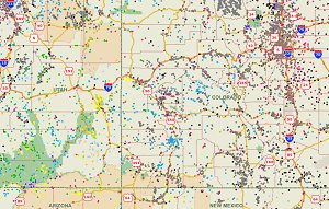
A Note About How Your GIS Maps Will Look
The image on this page is an example of how these shapefiles may look when loaded into a GIS program. Your GIS maps may not look exactly like this. Each GIS program is different. Shapefiles themselves are a collection of points, lines or polygons. They have no attributes. It is up to you, the user, to define colors, line width, symbols and other attributes within the limits and capabilities of the GIS programs you are using.
Copyright and Use of Shapefiles
The shapefiles on this page are copyrighted as follows. Copyright © 2017 Michael R. Meuser, All Rights Reserved. You may use these shapefiles in any GIS project or to make maps. You may not create copies of the shapefiles for the use of others whether for personal or commercial use. You may not resell the shapefiles. If you require multiple copies of the same shapefile, please contact Mike at [email protected]. Thank You.
About Quality, Accuracy and Suitability
Specifically, we were able to map 2,176,280 data point records from the latest GNIS data. We were not able to map 69,207 records because they lacked the necessary longitude and latitude. What this means is that we were able to convert 96.82% of the data into shapefiles while we were not able to convert 3.8% of the data. Those records not mapped are available to you in the following formats: Open Office Calc, MS Excel and DBF.
Generally, the geodata and shapefiles found at MapCruzin.com may come from a variety of
government, non-governmental and self-reporting private
sources. While we try to assure the accuracy of
this material, we cannot promise that it is
absolutely accurate. We do promise that using the
map layer will be fun, entertaining or educational - possibly even frustrating.
Beyond this, we make no guarantee as to its
suitability for any purpose. We assume no liability
or responsibility for errors or inaccuracies. Please
understand that you download and use these map layers and data at your own
risk.
<-- Return to Do It Yourself GIS Maps
Didn't find what you are looking for? We've been online since 1996 and have created 1000's of pages. Search below and you may find just what you are looking for.
Michael R. Meuser
Data Research & GIS Specialist
MapCruzin.com is an independent firm
specializing in GIS project development and data research.
We created the first U.S. based
interactive toxic chemical facility
maps on the internet in 1996 and we
have been online ever since. Learn more about us and our services.
Have a project in mind? If you have data, GIS project or custom shapefile needs contact Mike.
Contact Us
Report Broken Links
Subscribe for Updates
|


