Tools & resources for re-imagining our relationships with each other and the earth
Home   Free GIS   Free Shapefiles   Free Maps   News   TOPO   Google Earth Maps   Satellite   GPS   Learn GIS   BLOG

Subscribe for updates,
feeds, and newsletter
Enter your email address:

Delivered by FeedBurner

Indian and Federal Lands Shapefiles - Indian Lands, National Park Service, U.S. Forest Service, Bureau of Land Managment ... more

Mapcruzin Free GIS Tools, Resources, News and Maps

Follow Mapcruzin.com on Twitter
Follow on Twitter

A Member of the
Reimagination Network

Didn't find what you are looking for? Email me and I'll find it for you.

Have a question or comment? Post them at the MapCruzin Blog.

Climate Shift Blog

Recycling Secrets Blog

GIS Tutorials

GIS Basics

GIS Terminology

Of Interest

Home Based Recycling Business - Free resources and tools.

Reimagination - Reimagining, exploring and celebrating the changes in infrastructure, politics and culture that will help us live in harmony with each other and the earth now and in the future.

Arctic National Wildlife Refuge

Climate Shift - The effects of climate shift on the future of planet earth and its inhabitants.

Right to Know or Left to Wonder?

Shrubbed

Terrorspeak

21st Century Warfare

Hazardscapes - Toxic and Nuclear Risks in your backyard.

War & Environment

Worst Case Scenarios: Terrorism & industrial chemicals.

Redwood Ecotours: Explore California's Redwood North Coast.


poets against the war

Right To Know Network - environmental information and databases

Viewable with ANY browser


Free Wireless ArcGIS GIS Shapefile Map Layers

<-- Free GIS Software
<-- More Free GIS Shapefiles
<-- Wireless and Cell Phone Risks

See Also:
Congressional Hearings and EWG Reports about cell phone risks - Transcripts, videos, studies and documents.


This is a map I created using the shapefiles listed below. There are tens of thousands of points. Click here for an older project based on this geospatial data.

FCC Licensing Database Extract Shapefiles, FCC Market Boundary File Shapefiles, Base Layer Shapefiles, Learn More, Using Wireless Layers.

FCC Licensing Database Extract Shapefiles

ArcGIS GIS shapefile map layers available for download include:

  • AM Broadcast

  • Antenna Structure Registration

  • Broadband Radio and Educational Radio Services

  • Cellular

  • Cellular Service Area Boundaries

  • FM Broadcast

  • Land Mobile - Commercial

  • Land Mobile - Private

  • Land Mobile - Broadcast

  • Microwave

  • Paging

  • TV - NTSC

  • TV - Digital

  • TV Contours NTSC & Digital

Read Descriptions and Download the FCC Licensing Database Extract Shapefiles

FCC Market Boundary File Shapefiles

Arc GIS shapefile map layers available for download include:

  • Cellular Market Areas

  • Basic Trading Areas

  • Major Trading Areas

  • Regional PCS Areas

  • Economic Areas

  • Major Economic Areas<

  • Regional Economic Areas

  • Economic Area Groupings

  • VHF Public Coast Station Areas

  • Public Safety Planning Regions

Read Descriptions and Download the FCC Market Boundary File Shapefiles

Base Layer Shapefiles

ESRI format ArcGIS GIS shapefile map layers available for download include:

  • American Indian Reservations

  • U.S. Major Roads

  • U.S. Cities and Towns

  • U.S. Airports

  • U.S. Railroads

  • U.S. 110th Congressional Districts

  • 2000 Urbanized Areas

Download the Base Layer Shapefiles

Learn More

Glossary of frequently used telecommunication terms.

Learn more about the FCC Universal Licensing System (ULS).

Glossary FCC Universal Licensing System.

Search the FCC Universal License System by city, state, zip, call letters and more - also provides geosearch capabilities.

Learn more about the FCC Antenna Registration Service (ASR).

Search the FCC antenna registration database by city, state and more and map the results.

FAQ for the FCC antenna registration database.

Visit FCC's GIS website for more information.

<-- Free GIS Software
<-- More Free GIS Shapefiles
<-- Wireless and Cell Phone Risks

See Also:
Congressional Hearings and EWG Reports about cell phone risks - Transcripts, videos, studies and documents.

About Quality, Accuracy and Suitability

This data may come from a variety of U.S. government and self-reporting private sources. While we try to assure the accuracy of this material, we cannot promise that it is absolutely accurate. We do promise that using the map layer will be fun, entertaining or educational. Beyond this, we make no guarantee as to its suitability for any purpose. We assume no liability or responsibility for errors or inaccuracies. Please understand that you use these map layers at your own risk.

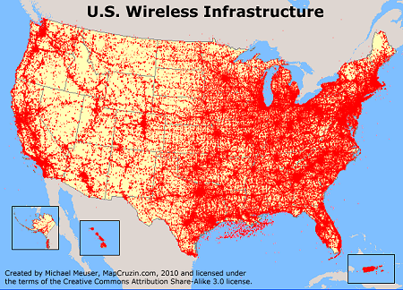
Further, the user should give credit to the Federal Communications Commission for the data. The user must abide by the following data disclaimer. All information within the product is believed accurate but is not guaranteed without error. While attempts have been made to insure the correctness of the information presented, neither the FCC nor any party involved in the creation and compilation of the data guarantees their accuracy, completeness, or suitability for a particular use. All critical information should be independently verified.

FCC Licensing Database Extract Shapefiles, FCC Market Boundary File Shapefiles, Base Layer Shapefiles, Learn More, Using Wireless Layers.


MapCruzin.com is an independent firm specializing in the publication of educational and research resources. We created the first U.S. based interactive toxic chemical facility maps on the internet in 1996 and we have been online ever since. Learn more about us and view some of our projects and services.

Contact Us

Report Broken Links

Didn't find what you are looking for? We've been online since 1996 and have created 1000's of pages. Search below and you may find just what you are looking for.

Bookmark and Share

Most Popular:
Renewable Energy Shapefiles, Oil & Gas Field Energy, Renewable Energy Potential Maps, Residential Energy Consumption Maps, 2009 Tiger Line Shapefiles, World Energy Maps, Haiti Earthquake Maps & Resources, Orbit Free GIS for Mac OSX, Win 32 & 64, Unix, FCC Wireless Licensing and Market Boundary Shapefiles, TRI National Analysis Data, Shapefiles, U.S. State ArcGIS Shapefiles, Afghanistan ArcGIS Shapefiles, Free GIS & Geospatial Software, Afghanistan Maps, Natural Disaster ArcGIS Shapefiles, U.S. State Maps, Satellite & Aerial Photos, Health Uninsured Maps, Climate Change, Cell Phone Health, Towers, Maps, Chemical Terrorism, Transportation Shapefiles, Toxics, Chemicals, Schools, Google Earth & Maps, Indian & Federal Lands Shapefiles, Arctic National Wildlife Refuge Maps, Economy Maps, TOPO Maps, MapCruzin Blog

Free Shapefiles:
New Additions
FCC Wireless Licensing and Market Boundary Shapefiles, TRI National Analysis Data, Shapefiles, U.S. State ArcGIS Shapefiles, Afghanistan ArcGIS Shapefiles, Natural Disaster ArcGIS Shapefiles, Renewable Wind Energy Shapefiles, EPA Criteria Pollutant Shapefiles, North American Transportation Shapefiles, 2009 Tiger Line, State GIS, World Country ArcGIS, U.S. State GIS Resources, Climate Maps, Canada, Mexico, U.S. Transportation, ArcGIS shapefiles, Neighborhood Boundary, Satellite Aerial
Oil & Gas Field Energy, Toxic Risks, Neighborhoods & Schools, EPA Geospatial, U.S. Boundary Shapefiles, H1N1 Swine Flu, EPA TRI Toxic Release Inventory, Pollution Maps

MapCruzin Blog for updates, questions and answers

Blog Updates

More Blog Updates

Partners
Climate Shift, Recycle, Reuse & Salvage, TerraKnowledge.net, Climate Injustice, Pollution Map Projects, News & Resources, Blue Creek - Ah Pah, Right Livelihoods, Reimagination, Redwood Ecotours

Can we do a project for you?

MapCruzin Consulting
GIS and Google Maps Development, Website Creation and Hosting, Fast and Affordable.

Downloads

Google Earth Toxic Release Inventory (TRI) Maps
Lester Brown's Plan B 3.0
State GIS Shapefiles, Maps & Resources
GIS Shapefiles & Maps
GIS Programs, Tools & Resources
Free World Country & Regional Maps
GIS / GPS Careers and Job Positions
Disease Outbreak Maps
TOPO Maps
Extreme Weather & Disaster Maps
Free World Maps from the CIA Factbook
Arctic National Wildlife Refuge ANWR Maps
Oil and Gas Maps
Africanized Honey Bees
Renewable Energy Potential Maps of the United States
Terrorism Maps
War Maps
Google Maps
Weather Maps
GPS Resources
Historical Maps of the World
Google Earth
Library of Congress American Memory Map Downloads
Toxic Chemical Pollution Maps
Climate Change Maps
Toxic Release Inventory (TRI) Maps
Census Shapefiles
World Maps

Issues

Environmental Justice
Data Sources
Greenwash & JunkScience
Statistical Resources
Wireless Dangers
Surviving Climate Change
Global Right-To-Know
Creating Living Economies
Books of Note
Toxic Klamath River
Federal Lands Maps
TRI Analysis
TRI Webmaps
EnviroRisk Map Network
Community-Based Research
Right-To-Know or Left to Wonder?
Chemical Industry Archives
21st Century Warfare
Biotechnology
Nanotechnology
Globalization/Democracy
Shrubbed
National Parks and Public Lands
Trade Secrets/Toxic Deception
GIS Books
Our Projects
Other Projects
1999 Archive Environews
Environmental Books
Environmental Links
Redwood Coast Information
Recycle, Salvage, Reuse

Resources

Environmental Book Discounts
Korten - Speth - Bullard
Environmental Justice
Hawken - Climate Change
Peak Oil - Alternative
Energy - Nuclear Risk
Water Crisis - Food Crisis
Energy Crisis - Housing
Crisis

GIS Book Discounts
GIS - GPS - Remote
Sensing - Google Maps
Cartography - Geography
Maps - Google Earth

About MapCruzin - Privacy, Fair Use and Disclaimer - Advertise on MapCruzin.com

Home | Free GIS | Downloads | Parks & Public Lands | Books | Environmental Justice | News Archives
Free GIS Tutorial | Consulting | TRI 2004 MAPS | Recycle Reuse Business | Toxics Explorer
North Coast GIS | Contact/About Us | Redwood Ecotours | Global Positioning | EnviroRisk Map Network
Climate Collapse | Free GIS Tutorial | What is GIS? | Right to Know | Reimagination | Health & GIS | Shrubbed | Search

Questions, Comments or Suggestions? Contact Us

Website development and hosting provided by the Reimagination Network

Copyright © 1996 - 2010 Reimagination Network, All Rights Reserved
MapCruzin is a Pop-Up Free Website -- Best Viewed With ANY Browser