Home   Store   Free GIS   Education   Free Shapefiles   Census   Weather   Energy   Climate Change   News   Maps   TOPO   Aerial   GPS   Learn GIS

DOWNLOAD SHAPEFILES: Canada FSA Postal - Zip Code - U.S. Waterbodies & Wetlands - Geographic Names - School Districts - Indian Federal Lands
Zip Code/Demographics - Climate Change - U.S. Streams, Rivers & Waterways - Tornadoes - Nuclear Facilities - Dams & Risk - 2013 Toxic Release Inventory TRI

ANWR Arctic National Wildlife Refuge; What is at stake; removed USFWS website; photos, maps, descriptions

tools for survival plans Maps Food Water Health Gardening Energy Housing Security Communications Livelihood

Money Making Tips Work from Home Make Money Used Lumber & Building Materal Beginner's Guide Buy/Sell Gold Electronics & Computer

GIS Shapefile Store - for Beginners & Experienced GIS Users Alike. Geographic Names Information System, Nuclear Facilities, Zip Code Boundaries, School Districts, Indian & Federal Lands, Climate Change, Tornadoes, Dams - Create digital GIS maps in minutes.

Toxic Release Inventory TRI Shapefiles

Canada FSA Postal Code Shapefile

GNIS Shapefiles 2,000,000+ Points

Nuclear Energy Facilities in the U.S.

Download Zip Code with Demographics Shapefiles

Download U.S. Streams & Rivers Shapefiles

Download Water Body & Wetland Shapefiles

Download Zip Code Boundary Shapefiles

Download School District Shapefiles

Download Indian & Federal Land Shapefiles

Download Climate Change Shapefiles

Download Tornado Shapefiles

Download Dams & Risks Shapefiles

Follow Mapcruzin.com on Twitter Follow on Twitter

Didn't find what you are looking for? Email me and I'll find it for you.

Progressive Links

Federation of American Scientists

Physicians for Social Responsibility

Public Employees for Environmental Responsibility

Union of Concerned Scientists

Alternet

Reader Supported News

Common Dreams

Truthout

Huffington Post

Media Matters

Think Progress

Grist Environmental News

Climate Shift Blog

MapCruzin Consulting
Data Research and GIS Specialists.

GIS Tutorials

GIS Basics

GIS Terminology

Of Interest

Arctic National Wildlife Refuge Maps

Climate Shift - The effects of climate shift on the future of planet earth and its inhabitants.

Right to Know or Left to Wonder?

Hazardscapes - Toxic and Nuclear Risks in your backyard.

War & Environment

Worst Case Scenarios: Terrorism & industrial chemicals.

Introduction

I've done GIS mapping and demographic research here in Humboldt County and elsewhere, continued to develop GIS products like our free Toxic Release Maps and Learn2Map GIS Tutorial and done a bit of woodworking as well. My latest project is ToxicRisk.com - interactive maps of toxic facilities and schools in the U.S. Recently, Ernie Albers and I worked together to create the Yurok Plank House exhibit at the Clarke Museum in Eureka, California. Check YurokPlankHouse.com for more information about and photos of the project.

Much of the focus of my recent work has been on mapping pollution sources. To continue this work in Humboldt County I have the bare beginnings of what will be an interactive GIS web map of Humboldt County that visitors can use to locate polluting facilities and find out more about them. Check Redwood Coast Toxic Discoveries for more about this.

In 2007, I began working with Willard Carlson and others on Blue Creek - Ah Pah Traditional Yurok Village on the Klamath river.

I've created a digital map with multiple layers that shows both current landuses and ownership and the aboriginal Yurok territory. The map above is a first cut at doing just that.

You can download this map in high-quality Acrobat PDF format (397K). Note that it works best to right-click your mouse and choose "save file as" and pick a place to save it on your hard disk. Acrobat Reader is needed to view the downloaded map. If you don't have it, you can get it here. You can use the map in any manner that you like as long as you do not change the map or remove the copyright and source information. Please also keep in mind that there are limits to the accuracy of the maps. Read below for more on this.

Here are two more images from the map project. They are also available for download in Acrobat PDF format. Click on either map for a larger image and the PDF download link. Would you like to learn how to make maps like this yourself? Check below for free map layers and a GIS tutorial that includes access to a free GIS map viewer.

My wish list for the above map project is:

  • Update and verify the current layers.
  • Add more aboriginal boundaries.
  • Fine tune the aboriginal boundaries with the help and guidance of local native people.
  • Focus on the water quality of the Klamath and Eel Rivers and the health of their watersheds, looking at deforestation, sedimentation, pollution, flows, development, water temperature, river shading, fish kills, fishery health and the like.
  • Environmental justice mapping of potential toxic sources and demographics.
  • Other features that you in the community suggest or would like to add yourself. Please send me your wish list.

Download Map Layers, Program & Tutorial

You can download these layers and a free GIS program and explore the digital map yourself. I have a free GIS tutorial that you can download by clicking here.

These GIS map layers are in the industry standard shapefile format. Most any GIS program can use this format and they also work with the free GIS program, Arcexplorer. Arcexplorer is linked from within the free GIS tutorial (above) or you can download it directly at www.esri.com. Here are the map layers:

Note: files below last updated 04/22/04

  • All the layers bundled (zipped) with an Arcexplorer (aep) project. This file "northcoast.exe" is a self extracting file. Once you have downloaded it, double-click it and it will unzip to a directory on your "C" hard disk named "north-coast-gis." Once you have done this, open Arcexplorer, choose "open project" and locate the file named "northcoast.AEP." See our free GIS tutorial for more information on obtaining Arcexplorer and using it with this project. Click here to download the bundle. Note: this is a large 4.0MB file.

  • If you are already an experienced GIS user, you can download the individual shapefiles below:

Map Use and Accuracy

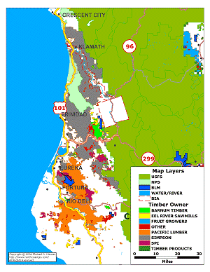
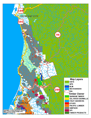
You can use the maps in any manner that you like as long as you do not change the map or remove the copyright and source information. Please also keep in mind that there are limits to the accuracy of the maps. Read below for more on this. Note that all of these map layers, with the exception of the Yurok aboriginal layer, were extracted from various U.S. government and other data sets. This data may or may not be accurate or current.

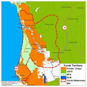
One part of this project is to verify the accuracy of each of these layers. The Yurok aboriginal layer was first scanned from a map in Yurok Geography by T.T. Waterman and then digitized with Maptitude GIS. This layer should be confirmed and/or adjusted with the direction of Yurok and neigboring tribal people.

For these reasons the maps shown on this page and the downloadable GIS layers should be considered a "first cut" -- a draft -- of the current and historical geography of the region. If you have information and/or would like to be part of working on this or any other map layer, please contact me using the form below.

Marlon Sherman, Professor of Native American Studies at Humboldt State University, prepared the following discussion about maps and boundaries of aboriginal territory.

"Boundary lines on maps are artificial constructs. Sharply delineated lines, drawn arbitrarily, generally have little meaning in aboriginal or indigenous terms. As a cultural or geographic matter, many, if not most indigenous societies were formed and maintained within watershed boundaries. As a political matter, many modern indigenous societies view boundaries as tools of oppressive colonial governments that facilitate repressive or genocidal policies. Indigenous Peoples throughout the earth generally coalesced as societies long before the formation of modern nation-states, and struggle with cross-boundary issues that result from differing immigration policies of the various nations.

The lines on the above map are used strictly for informational purposes, and cannot and should not be used to prove right to ownership of the parcels of land so delineated.

For example, the boundaries noted on the map of aboriginal Yurok territory are all either arbitrarily drawn by anthropologists/ethnologists, or are the results of government-approved surveys that have subsequently been entered into official county land records.

The anthropological lines only roughly approximate areas that Yurok-speaking peoples once either inhabited or visited and used on a regular basis. They are the result of first-person interviews with Yurok individuals in the early Twentieth Century as well as often unreliable information gleaned from non-Indian interlopers or surrounding tribal groups.

The history of government-recorded property lines delineating both private and government property in the West are generally the result of fraud and coercion, not only on the part of the miners, loggers and other settlers, but due to the third-party surveying contractors, some of whom never even walked the land they mapped. Although these property lines have become pretty much settled as of the 21st Century, they are still the source of much bitterness among Native Peoples, who lost the homes and use rights they had enjoyed for untold centuries.

Finally, although the United States government has since 1989 recognized a separate Yurok Reservation, with boundary lines extending from approximately the mouth of the Klamath River to its confluence with the Trinity River, and one mile on either side of the Klamath River, some Yurok people still practice traditional Yurok land use beliefs and practices in regard to land ownership and property boundaries, rather than acknowledge either Yurok or United States law.

This map, then, shows the approximate areas Yurok peoples lived in or utilized on a regular basis before the coming of Europeans or Americans, and shows areas Yuroks are forbidden from living or utilizing today, due to federal and state laws, as well as corporate and private control of lands."

Didn't find what you are looking for? We've been online since 1996 and have created 1000's of pages. Search below and you may find just what you are looking for.


Michael R. Meuser
Data Research & GIS Specialist

MapCruzin.com is an independent firm specializing in GIS project development and data research. We created the first U.S. based interactive toxic chemical facility maps on the internet in 1996 and we have been online ever since. Learn more about us and our services.

Have a project in mind? If you have data, GIS project or custom shapefile needs contact Mike.

Contact Us

Report Broken Links

Subscribe for Updates

Follow on Facebook
News & Updates

Find: Maps, Shapefiles, GIS Software & More

MapCruzin Blog for updates, questions and answers
Blog Updates

More Blog Updates

Downloads

Google Earth Toxic Release Inventory (TRI) Maps
Lester Brown's Plan B 3.0
State GIS Shapefiles, Maps & Resources
GIS Shapefiles & Maps
GIS Programs, Tools & Resources
Free World Country & Regional Maps
GIS / GPS Careers and Job Positions
Disease Outbreak Maps
TOPO Maps
Extreme Weather & Disaster Maps
Free World Maps from the CIA Factbook
Arctic National Wildlife Refuge ANWR Maps
Oil and Gas Maps
Africanized Honey Bees
Renewable Energy Potential Maps of the United States
Terrorism Maps
War Maps
Google Maps
Weather Maps
GPS Resources
Historical Maps of the World
Google Earth
Library of Congress American Memory Map Downloads
Toxic Chemical Pollution Maps
Climate Change Maps
Toxic Release Inventory (TRI) Maps
Census Shapefiles
World Maps

Issues

Environmental Justice
Data Sources
Greenwash & JunkScience
Statistical Resources
Wireless Dangers
Surviving Climate Change
Global Right-To-Know
Creating Living Economies
Books of Note
Toxic Klamath River
Federal Lands Maps
TRI Analysis
TRI Webmaps
EnviroRisk Map Network
Community-Based Research
Right-To-Know or Left to Wonder?
Chemical Industry Archives
21st Century Warfare
Biotechnology
Nanotechnology
Globalization/Democracy
National Parks and Public Lands
Trade Secrets/Toxic Deception
GIS Books
Our Projects
Other Projects
1999 Archive Environews
Environmental Books
Environmental Links
Redwood Coast Information
Recycle, Salvage, Reuse

Resources
Shapefile Store
Free GIS Software
Free Map Downloads
Free Shapefiles
Free Remote Sensing
Free Topo Maps
Free GIS Tutorial
Free GPS
ToxicRisk.com
ClimateShift.com
Maptivist.com

About MapCruzin - Cookies, Privacy, Fair Use and Disclaimer - Advertise on MapCruzin.com

Copyright © 1996 - 2019 Michael Meuser, All Rights Reserved
MapCruzin is a Pop-Up Free Website -- Best Viewed With ANY Browser