democratizing GIS
Home   Store   Free GIS   Education   Free Shapefiles   Census   Weather   Energy   Climate Change   News   Maps   TOPO   Aerial   GPS   Learn GIS

DOWNLOAD SHAPEFILES: Canada FSA Postal - Zip Code - U.S. Waterbodies & Wetlands - Geographic Names - School Districts - Indian Federal Lands
Zip Code/Demographics - Climate Change - U.S. Streams, Rivers & Waterways - Tornadoes - Nuclear Facilities - Dams & Risk - 2013 Toxic Release Inventory TRI

ANWR Arctic National Wildlife Refuge; What is at stake; removed USFWS website; photos, maps, descriptions

tools for survival plans Maps Food Water Health Gardening Energy Housing Security Communications Livelihood

Money Making Tips Work from Home Make Money Used Lumber & Building Materal Beginner's Guide Buy/Sell Gold Electronics & Computer

GIS Shapefile Store - for Beginners & Experienced GIS Users Alike. Geographic Names Information System, Nuclear Facilities, Zip Code Boundaries, School Districts, Indian & Federal Lands, Climate Change, Tornadoes, Dams - Create digital GIS maps in minutes.

Toxic Release Inventory TRI Shapefiles

Canada FSA Postal Code Shapefile

GNIS Shapefiles 2,000,000+ Points

Nuclear Energy Facilities in the U.S.

Download Zip Code with Demographics Shapefiles

Download U.S. Streams & Rivers Shapefiles

Download Water Body & Wetland Shapefiles

Download Zip Code Boundary Shapefiles

Download School District Shapefiles

Download Indian & Federal Land Shapefiles

Download Climate Change Shapefiles

Download Tornado Shapefiles

Download Dams & Risks Shapefiles

Follow Mapcruzin.com on Twitter Follow on Twitter

Didn't find what you are looking for? Email me and I'll find it for you.

Progressive Links

Federation of American Scientists

Physicians for Social Responsibility

Public Employees for Environmental Responsibility

Union of Concerned Scientists

Alternet

Reader Supported News

Common Dreams

Truthout

Huffington Post

Media Matters

Think Progress

Grist Environmental News

Climate Shift Blog

MapCruzin Consulting
Data Research and GIS Specialists.

GIS Tutorials

GIS Basics

GIS Terminology

Of Interest

Arctic National Wildlife Refuge Maps

Climate Shift - The effects of climate shift on the future of planet earth and its inhabitants.

Right to Know or Left to Wonder?

Hazardscapes - Toxic and Nuclear Risks in your backyard.

War & Environment

Worst Case Scenarios: Terrorism & industrial chemicals.

Map of the Nation's 101 Most Dangerous Chemical Facilities. Millions at Risk.

Sponsors

<-- Chemical Terrorism and Security

Source: American Progress

Visit the 101 Most Dangerous Chemical Facilities Interactive Maps.

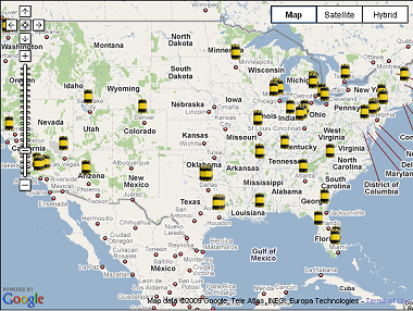
This map shows the locations of the nation's 101 most dangerous chemical facilities, each of which threatens some 1 million or more people. The vast majority of these facilities could convert to safer, more secure chemicals or processes.

Download Chemical Security 101

Click on an icon to see the facility name, the process it currently uses, and potential alternatives it could adopt. In a number of cities, multiple facilities are located very close to each other. Zoom in on the map to view these facilities.

Sponsors

Most of the nation's 101 most dangerous chemical facilities could become less attractive terrorist targets by converting to alternative chemicals or processes. Doing so would improve the safety and security of the more than 80 million Americans who are living within range of a worst-case toxic gas release from one of these facilities, according to data compiled by Paul Orum and Reece Rushing in the report "Chemical Security 101: What You Don't Have Can't Leak, or Be Blown Up by Terrorists."

Download Chemical Security 101

Visit the 101 Most Dangerous Chemical Facilities Interactive Maps.

Related Articles, Reports and Resources

Congress Deliberating HR 2868 - the Chemical Facilities Anti-Terrorism Act of 2009.

Chemical Security Legislation Clears Key House Subcommittee.

Chemical Security & Drinking Water Security Legislation Advances in House.

Map of the Nation�s 101 Most Dangerous Chemical Facilities. Millions at Risk.

Background Material on Chemical Terrorism, Security and Right-to-Know

Markey: Chemical Plants Must Take Common Sense Security Measures.

ATSDR Report on Chemical Terrorism and vulnerability of US Industrial plants.

Worst Case Scenario Terrorism and Toxic Chemical Accident.

Despite Terrorism Threat, Chemical Industry Succeeds In Blocking Federal Security Regulations.

STATEMENT ON PROTECTING PUBLIC HEALTH AND HAZARD REDUCTION (Chemical plants, terrorism, and right-to-know).

ToxicRisk.com is a map-based website that enables users to investigate facilities listed in the EPA Toxic Release Inventory (TRI), number of schools within 1 mile and within 5 miles of the facility, plus links to a database about the toxic history of the facility.

A First Look At The 600K Report: Commercial Chemical Incidents In The United States, 1987 - 1996.

Chemical Plants Are Feared as Targets: Concerns grow that terrorists might hit toxic inventories.

<-- Chemical Terrorism and Security

Didn't find what you are looking for? We've been online since 1996 and have created 1000's of pages. Search below and you may find just what you are looking for.


Michael R. Meuser
Data Research & GIS Specialist

MapCruzin.com is an independent firm specializing in GIS project development and data research. We created the first U.S. based interactive toxic chemical facility maps on the internet in 1996 and we have been online ever since. Learn more about us and our services.

Have a project in mind? If you have data, GIS project or custom shapefile needs contact Mike.

Contact Us

Report Broken Links

Subscribe for Updates

Sponsors

Advertise on MapCruzin

Follow on Facebook
News & Updates

Find: Maps, Shapefiles, GIS Software & More

MapCruzin Blog for updates, questions and answers
Blog Updates

More Blog Updates

Downloads

Google Earth Toxic Release Inventory (TRI) Maps
Lester Brown's Plan B 3.0
State GIS Shapefiles, Maps & Resources
GIS Shapefiles & Maps
GIS Programs, Tools & Resources
Free World Country & Regional Maps
GIS / GPS Careers and Job Positions
Disease Outbreak Maps
TOPO Maps
Extreme Weather & Disaster Maps
Free World Maps from the CIA Factbook
Arctic National Wildlife Refuge ANWR Maps
Oil and Gas Maps
Africanized Honey Bees
Renewable Energy Potential Maps of the United States
Terrorism Maps
War Maps
Google Maps
Weather Maps
GPS Resources
Historical Maps of the World
Google Earth
Library of Congress American Memory Map Downloads
Toxic Chemical Pollution Maps
Climate Change Maps
Toxic Release Inventory (TRI) Maps
Census Shapefiles
World Maps

Issues

Environmental Justice
Data Sources
Greenwash & JunkScience
Statistical Resources
Wireless Dangers
Surviving Climate Change
Global Right-To-Know
Creating Living Economies
Books of Note
Toxic Klamath River
Federal Lands Maps
TRI Analysis
TRI Webmaps
EnviroRisk Map Network
Community-Based Research
Right-To-Know or Left to Wonder?
Chemical Industry Archives
21st Century Warfare
Biotechnology
Nanotechnology
Globalization/Democracy
National Parks and Public Lands
Trade Secrets/Toxic Deception
GIS Books
Our Projects
Other Projects
1999 Archive Environews
Environmental Books
Environmental Links
Redwood Coast Information
Recycle, Salvage, Reuse

Resources
Shapefile Store
Free GIS Software
Free Map Downloads
Free Shapefiles
Free Remote Sensing
Free Topo Maps
Free GIS Tutorial
Free GPS
ToxicRisk.com
ClimateShift.com
Maptivist.com

About MapCruzin - Cookies, Privacy, Fair Use and Disclaimer - Advertise on MapCruzin.com

Copyright © 1996 - 2019 Michael Meuser, All Rights Reserved
MapCruzin is a Pop-Up Free Website -- Best Viewed With ANY Browser