Natural Disaster Series: Download free Hurricane GIS Shapefile
Sponsors
<-- Download ArcGIS Shapefiles
<-- More Natural Disaster Shapefiles
See Also:
New to GIS? Read about it here and learn the basics with our free Learn2Map GIS Tutorial and Atlas.
View Metadata
Download the Hurricane Shapefile
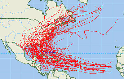
The paths of tropical cyclones and major hurricanes from 1851 to 2004.
The term "tropical cyclone" is a generic term for a low-pressure storm system that usually forms in the tropics. The unpredictable behavior, high seas, and devastating winds of tropical storms have challenged us for centuries. One of our best defenses against hurricanes and other tropical storms is informed readiness. The National Hurricane Center (NHC), part of the National Oceanic and Atmospheric Administration, National Weather Service (NWS), collects tropical cyclone data as part of its mission to save lives and mitigate property loss by issuing advisories of hazardous tropical weather. The NHC tracks hurricanes and other tropical cyclones over the Atlantic, Caribbean, Gulf of Mexico, and Eastern Pacific and issues hurricane forecasts, watches, and warnings to the public. Computer models are used to forecast the track and intensity of a tropical storm. These statistical models use current information about a storm and compare it with historical knowledge about the behavior of similar tropical storms. The historical record for storms over the North Atlantic begins in 1851, and the record in the Pacific begins in 1949.
Tropical storms are classified by wind speed and by the structure of the storm and include hurricanes, other tropical cyclones, subtropical cyclones, and related storms. The highest intensity storms, with the highest wind speeds, are hurricanes. Lower intensity storms have lower wind speeds and may not exhibit the convection and circulation properties found in hurricanes. Lower intensity storms can sometimes inflict greater damage than storms of higher intensity, depending on where they strike and the particular hazards they bring.
Sponsors
A tropical cyclone is a warm-core, non-frontal low-pressure system that develops over tropical or subtropical waters, covering a large region and with organized convection (i.e. thunderstorm activity) and definite cyclonic (counter-clockwise circular) surface wind circulation. Examples are hurricanes, tropical depressions, and tropical storms. A subtropical cyclone, such as a subtropical depression or storm, is a low pressure system that develops over subtropical waters and that initially has a non-tropical circulation but in which some elements of tropical cyclone cloud structure are present. Subtropical cyclones can evolve into tropical cyclones. Related storms are those that develop into subtropical or tropical cyclones or develop from them, such as tropical disturbances, lows, waves, and extratropical storms.
View Metadata
Download the Hurricane Shapefile
See Also:
New to GIS? Read about it here and learn the basics with our free Learn2Map GIS Tutorial and Atlas.
<-- Download ArcGIS Shapefiles
<-- More Natural Disaster Shapefiles
About Quality, Accuracy and Suitability
This data may come from a variety of U.S. government and self-reporting private sources. While we try to assure the accuracy of this material, we cannot promise that it is absolutely accurate. We do promise that using the map layer will be fun, entertaining or educational. Beyond this, we make no guarantee as to its suitability for any purpose. We assume no liability or responsibility for errors or inaccuracies. Please understand that you use these map layers at your own risk.
Didn't find what you are looking for? We've been online since 1996 and have created 1000's of pages. Search below and you may find just what you are looking for.
Michael R. Meuser
Data Research & GIS Specialist
MapCruzin.com is an independent firm
specializing in GIS project development and data research.
We created the first U.S. based
interactive toxic chemical facility
maps on the internet in 1996 and we
have been online ever since. Learn more about us and our services.
Have a project in mind? If you have data, GIS project or custom shapefile needs contact Mike.
Contact Us
Report Broken Links
Subscribe for Updates
| 


