GIS Shapefile Store - for Beginners & Experienced GIS Users Alike. Geographic Names Information System, Nuclear Facilities, Zip Code Boundaries, School Districts, Indian & Federal Lands, Climate Change, Tornadoes, Dams - Create digital GIS maps in minutes.
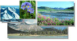
The arctic tundra contains ground features not found in warmer regions. The arctic is so cold
that the ground beneath the tundra surface remains frozen all year. This permanently frozen
ground is called permafrost. The soil in the permafrost area remains colder than 32
degrees Fahrenheit (0 degrees Celsius).
If the soil never warmed up, there would be no plants growing in the arctic. When the
summer sun warms the tundra surface, however, the top few inches of soil thaw. This melted
part is called the active layer. Plant roots grow within the active layer, and insects
burrow here.
What date do you think the active layer is melted deepest? You may be surprized...
Unearth the mysteries of the active layer.
This is a bluff on the coast of the Arctic Ocean.
Waves have eroded the soil, exposing the ground beneath the tundra surface. Frozen soil can
contain ice, like this ice wedge, or it can be dry, like the soil around the ice wedge.
Another ice wedge, this one exposed along a
river bank.
The soil buckles and cracks above the ice wedges,
causing these polygons to form (in the lower half of the picture).
The long, narrow lake in the center of the picture is a thermocarst lake.
A closer view of some arctic polygons. These are
about 70 feet (20 meters) across, although polygons may be as small as 10 feet (about 3 meters)
across.
Ice wedges form a honeycomb of ice walls beneath the soil surface. Look again at the ice
wedge at the beginning of this web page. Notice that on either side of it, other wedges are
partially visible in side view.
Pingos form when water moves up under the root
mat, and freezes. When water freezes it expands, pushing up the soil. Pingos can be as small as
one foot high (one third of a meter) or over 35 feet high (over 10 meters). This one is about 4
feet high (just over one meter).
When the soil on a pingo cracks open, and the ice
core is exposed, the pingo begins to melt and break up.
Note: This is the MapCruzin.com archive of the FWS Arctic National Wildlife Refuge website. In December, 2001 FWS took this website offline, making it unavailable to the public. It includes 90 plus pages of information and many maps. As of 2006 the important information contained in this, the original "unsanitized" version of the FWS website, has yet to return to the internet, so we will continue to maintain it here as a permanent archive to help inform activists and concerned citizens. If you find any broken links, please report them to me at [email protected] and I will attempt to make the repairs. January, 2008 update - A small part of the original information that was present in 2001 has made it back into the current ANWR website. There is also an archive that contains a small amount of the original information, but it is not readily available from the main website.
Click here to visit our homepage. Click here for NRDC's message about ANWR from Robert Redford.
U.S. Fish and Wildlife Service. 2001. Potential impacts of proposed oil and gas
development on the Arctic Refuge�s
coastal plain: Historical overview and
issues of concern. Web page of the Arctic National
Wildlife Refuge,
Fairbanks, Alaska.
17 January 2001. http://arctic.fws.gov/issues1.html
Archived by MapCruzin.com. Visit us at mapcruzin.com.
MapCruzin.com is an independent firm
specializing in the publication of
educational and research resources.
We created the first U.S. based
interactive toxic chemical facility
maps on the internet in 1996 and we
have been online ever since. Learn more about us and view some of our projects and services.


 This is a bluff on the coast of the Arctic Ocean.
Waves have eroded the soil, exposing the ground beneath the tundra surface. Frozen soil can
contain ice, like this ice wedge, or it can be dry, like the soil around the ice wedge.
This is a bluff on the coast of the Arctic Ocean.
Waves have eroded the soil, exposing the ground beneath the tundra surface. Frozen soil can
contain ice, like this ice wedge, or it can be dry, like the soil around the ice wedge.
 Another ice wedge, this one exposed along a
river bank.
Another ice wedge, this one exposed along a
river bank.
 The soil buckles and cracks above the ice wedges,
causing these polygons to form (in the lower half of the picture).
The soil buckles and cracks above the ice wedges,
causing these polygons to form (in the lower half of the picture).
 Pingos form when water moves up under the root
mat, and freezes. When water freezes it expands, pushing up the soil. Pingos can be as small as
one foot high (one third of a meter) or over 35 feet high (over 10 meters). This one is about 4
feet high (just over one meter).
Pingos form when water moves up under the root
mat, and freezes. When water freezes it expands, pushing up the soil. Pingos can be as small as
one foot high (one third of a meter) or over 35 feet high (over 10 meters). This one is about 4
feet high (just over one meter).
 When the soil on a pingo cracks open, and the ice
core is exposed, the pingo begins to melt and break up.
When the soil on a pingo cracks open, and the ice
core is exposed, the pingo begins to melt and break up.
 January 29, 2008: