Tools & resources for re-imagining our relationships with each other and the earth
Home   Free GIS   Free Shapefiles   Free Maps   News   TOPO   World Shapefiles   Toxic Schools   Learn GIS   JOBS

Free Newsletter
Signup for updates and additions.

Indian and Federal Lands Shapefiles - Indian Lands, National Park Service, U.S. Forest Service, Bureau of Land Managment ... more

A Member of the
Reimagination Network

Didn't find what you are looking for? Email me and I'll find it for you.

Have a question or comment? Post them at the MapCruzin Blog.

Download Census 2008
Tiger/Line ArcGIS Shapefiles

Free Tiger files now available for download in ESRI shapefile format.

Indian & Federal Lands - Maps in shapfile format.

Reimagination - Alternative resources for Today and Tomorrow.

Climate Change Maps

GPS Global Positioning

Free World Regional Maps - high resolution JPG and PDF downloads

Free TOPO and
Terrain Maps

USGS Digital Raster Graphic (DRG) Topographic Maps, Satellite and more.

Arctic National Wildlife Refuge Maps

Google Earth & Maps Resources & Tools

GIS Maps of Africa

GIS Maps of Ecosystems

Environmental GIS Maps

Wireless Maps - cellular

Historical Maps

MrSid, JPEG2000 & TIFF

Health & GIS

GIS Tutorials

GIS Mapping Resources

Census Data & Maps

Digital Data & Maps

Toxic Release Maps

GIS Explained

Featured

Home Based Recycling Business - Free resources and tools.

Reimagination - Reimagining, exploring and celebrating the changes in infrastructure, politics and culture that will help us live in harmony with each other and the earth now and in the future.

Toxic Klamath River

Arctic National Wildlife Refuge

Democracy at Risk: California Secretary of State Debra Bowen's report Top To Bottom Review finds that electronic voting machines supplied by several vendors are subject to hacking and inaccuracies.

Climate Shift - The effects of climate shift on the future of planet earth and its inhabitants.

Right to Know or Left to Wonder?

Shrubbed

Terrorspeak

Soaring Cancer Rates Blamed On Chemicals: Epidemic is Preventable. New report from CCPA.

21st Century Warfare

Hazardscapes - Toxic and Nuclear Risks in your backyard.

War & Environment

Worst Case Scenarios: Terrorism & industrial chemicals.

Redwood Ecotours: Explore California's Redwood North Coast.


poets against the war

World View of Global Warming

Viewable with ANY browser


Partners

SocioDemographics.com
Learn2map.com
Reimagination.com
RedwoodEcotours.com
NorthCoastGis.com
RecyclingSecrets.com
ClimateInjustice.com
bluecreekahpah.org
ClimateShift.com
ToxicRisk.com
MichaelMeuser.com
MorgellonsMaps.com

snow, flowers, mountains, lakeArctic National Wildlife Refuge
Refuge Information | Wildlife | Habitat | People
Home | New | Feedback | Index | Search

Why we archived the ANWR website at MapCruzin.com

Ice Wedges, Polygons, and Pingos

As the arctic soil freezes and thaws over many hundred years, it is cracked and buckled to create ice wedges, polygons, thermocarst lakes, and pingos. This web page includes:

Steps of the cycle
Animation of the cycle

Steps of the cycle:

There are a number of ways that polygons, arctic lakes, and pingos form. Here's one way this cycle works in the northern part of the Refuge:

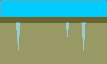
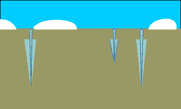
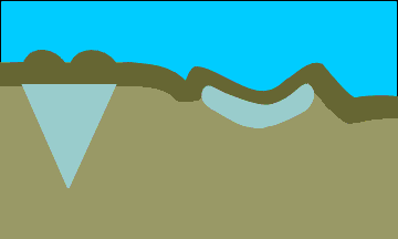
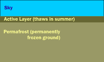
A cut-away view of the tundra in summer. The active layer is thawed.

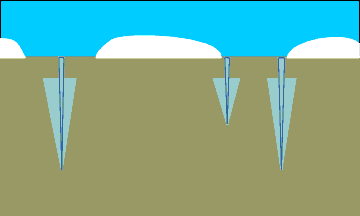
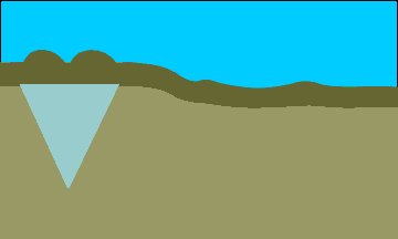
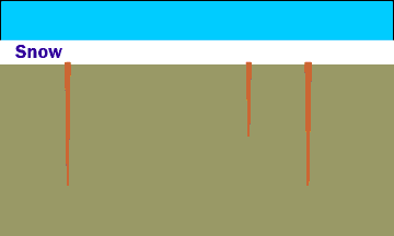
Winter cold causes the soil to shrink, and cracks to form. The active layer is frozen, so it acts just like the permafrost soils beneath it.

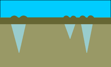
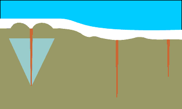
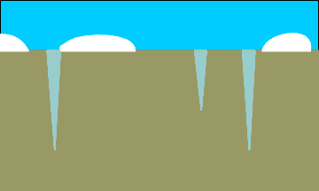
During warm spring days, water seeps into the cracks. It freezes and expands when it is chilled by the still-frozen soil. The frozen water forms wedges of ice in the soil.

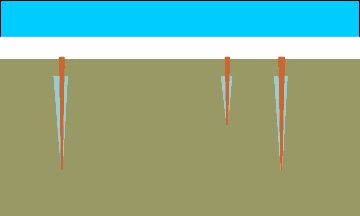
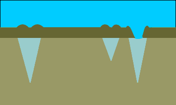
In summer, the active layer and the tops of the ice wedges melt.

Each winter, cracks form again in the same places...

and each spring, additional water enters and enlarges the ice wedges as the freezing water expands.

This cycle of crack, melt, and freeze continues to enlarge the wedges year by year...

until the soil above the wedges is pushed up, forming ridges. If you look down from above, these ridges create a blocky pattern on the ground, called polygons.

If the ice is exposed, a wedge may begin to melt.

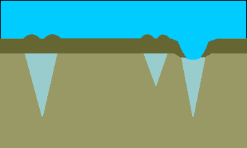
As more ice is exposed, the ice wedge and the active layer melt lower...

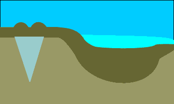
until a pond begins to form.

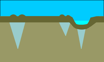
The pond water holds heat from the summer sun, so the active layer melts deeper beneath the water.

Seen from above, these lakes (called thermocarst lakes) can become longer in one direction when prevailing winds blow waves against the down-wind shore.

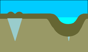
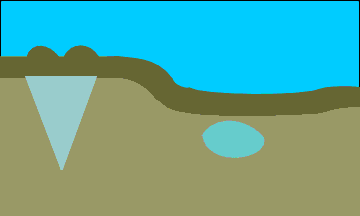
The lake side may break down, causing the lake to drain.

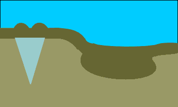
Without its insulating cover of water, the active layer begins to refreeze.

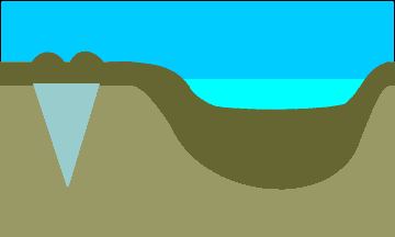
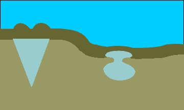
In winter, the surface freezes over a thawed remnant of the active layer.

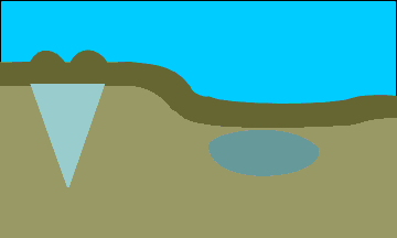
The very wet soil continues to freeze within the permafrost layer, even in summer.

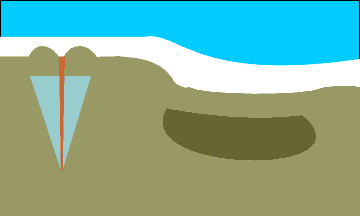
As the unfrozen area continues to contract, the unfrozen water is squeezed under great pressure.

Eventually, the water is under such pressure that it pushes upward (the direction of least resistance)...

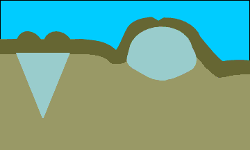
until the unfrozen water collects under the root mat, and freezes, creating a pingo.

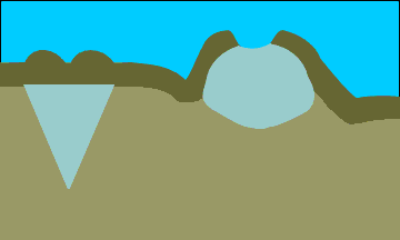
If the root mat cracks open enough to expose the ice, the pingo top begins to melt.

As the ice core continues to melt, the pingo collapses further.

Continued melting over many years removes most traces of the pingo.

If conditions are right, the cycle will begin again.

Return to top

Animation of the cycle:

The full cycle in action:

Return to top

Refuges: where wildlife comes first

Refuge Information | Wildlife | Habitat | People
Home | New | Feedback | Index | Search

Text and graphics by USFWS staff
Last modified 28 July 2000

Why we archived the ANWR website at Mapcruzin.com

Note: This is the MapCruzin.com archive of the FWS Arctic National Wildlife Refuge website. In December, 2001 FWS took this website offline, making it unavailable to the public. It includes 90 plus pages of information and many maps. As of 2006 the important information contained in this, the original "unsanitized" version of the FWS website, has yet to return to the internet, so we will continue to maintain it here as a permanent archive to help inform activists and concerned citizens. If you find any broken links, please report them to me at mike@learn2map.com and I will attempt to make the repairs. January, 2008 update - A small part of the original information that was present in 2001 has made it back into the current ANWR website. There is also an archive that contains a small amount of the original information, but it is not readily available from the main website.

Click here to visit our homepage. Click here for NRDC's message about ANWR from Robert Redford.

For more information on why this website was "pulled," Check here. And, you can also view the maps of caribou calving areas that the FWS did not want you to see here.

January 29, 2008: Visit Our New ANWR News for Updates


This page should be cited as follows:

U.S. Fish and Wildlife Service. 2001. Potential impacts of proposed oil and gas
       development on the Arctic Refuge’s coastal plain: Historical overview and
       issues of concern. Web page of the Arctic National Wildlife Refuge,
       Fairbanks, Alaska. 17 January 2001. http://arctic.fws.gov/issues1.html


Archived by MapCruzin.com. Visit us at www.mapcruzin.com.

MapCruzin.com is an independent firm specializing in the publication of educational and research resources. We created the first U.S. based interactive toxic chemical facility maps on the internet in 1996 and we have been online ever since. Learn more about us and view some of our projects and services.

Contact Us

Report Broken Links

Custom Search

Most Popular:
Cell Phone Risk, Towers, Maps, Chemical Terrorism, Satellite & Aerial Photos, Renewable Energy Shapefiles, Climate Change, Environmental Reading, Transportation Shapefiles, Toxics, Chemicals, Schools, Google Earth & Maps, GIS Book Discounts, Indian & Federal Lands Shapefiles, Arctic National Wildlife Refuge Maps, Economy Maps, Afghanistan Maps, TOPO Maps, MapCruzin Blog

Partners
Recycle, Reuse & Salvage, Climate Injustice, Pollution Map Projects, News & Resources, Reimagination, Redwood Ecotours

Free Maps:
New Additions
U.S. Economy, Historical, World Country, Extreme Weather & Disaster, Climate Change, Disease & Injury Mortality Maps, Google Earth Maps, War in Afghanistan, TOPO and Terrain, Energy, Climate, Landuse, Ethnicity, Religion, Military, Economy, Renewable Energy Potential, MrSid, JPEG2000 and GeoTIFF, Oil & Gas Field Energy, Toxic Risks, Neighborhoods & Schools, Residential Energy Consumption, ANWR Caribou Calving, Satellite Aerial, Chemical Pollution, National Parks, Monuments, Historic Sites, Google Earth Toxics, Oil & Gas, Cell Tower

MapCruzin Blog for updates, questions and answers

Blog Updates

More Blog Updates

Can we do a project for you?

We'll send feeds to you
Enter your email address

Delivered by FeedBurner

MapCruzin Consulting
GIS and Google Maps Development, Website Creation and Hosting, Fast and Affordable.

Follow Mapcruzin.com on Twitter
Follow on Twitter

2007 TRI Toxic Release Inventory and School Google Maps
TOXICS AND Children's Health - Learn more about the toxic chemical risks near your schools and in your backyards. Latest 2007 Toxic Release Inventory TRI (released 03/19/2009) and schools with Google Maps and searchable EPA Risk Management Plan database.

Toxic Chemical Pollution, Schools & Children's Health News

Right to Know or Left to Wonder?

News Archives

Downloads

Google Earth Toxic Release Inventory (TRI) Maps
Lester Brown's Plan B 3.0
State GIS Shapefiles, Maps & Resources
GIS Shapefiles & Maps
GIS Programs, Tools & Resources
Free World Country & Regional Maps
GIS / GPS Careers and Job Positions
Disease Outbreak Maps
TOPO Maps
Extreme Weather & Disaster Maps
Free World Maps from the CIA Factbook
Arctic National Wildlife Refuge ANWR Maps
Oil and Gas Maps
Africanized Honey Bees
Renewable Energy Potential Maps of the United States
Terrorism Maps
War Maps
Google Maps
Weather Maps
GPS Resources
Historical Maps of the World
Google Earth
Library of Congress American Memory Map Downloads
Toxic Chemical Pollution Maps
Climate Change Maps
Toxic Release Inventory (TRI) Maps
Census Shapefiles
World Maps

Issues

Environmental Justice
Data Sources
Greenwash & JunkScience
Statistical Resources
Wireless Dangers
Surviving Climate Change
Global Right-To-Know
Creating Living Economies
Books of Note
Toxic Klamath River
Federal Lands Maps
TRI Analysis
TRI Webmaps
EnviroRisk Map Network
Community-Based Research
Right-To-Know or Left to Wonder?
Chemical Industry Archives
21st Century Warfare
Biotechnology
Nanotechnology
Globalization/Democracy
Shrubbed
National Parks and Public Lands
Trade Secrets/Toxic Deception
GIS Books
Our Projects
Other Projects
1999 Archive Environews
Environmental Books
Environmental Links
Redwood Coast Information
Recycle, Salvage, Reuse

Resources

Environmental Book Discounts
Korten - Speth - Bullard
Environmental Justice
Hawken - Climate Change
Peak Oil - Alternative
Energy - Nuclear Risk
Water Crisis - Food Crisis
Energy Crisis - Housing
Crisis

GIS Book Discounts
GIS - GPS - Remote
Sensing - Google Maps
Cartography - Geography
Maps - Google Earth

About MapCruzin - Privacy, Fair Use and Disclaimer - Advertise on MapCruzin.com

Home | Free GIS | Downloads | Parks & Public Lands | Books | Environmental Justice | News Archives
Free GIS Tutorial | Consulting | TRI 2004 MAPS | Recycle Reuse Business | Toxics Explorer
North Coast GIS | Contact/About Us | Redwood Ecotours | Global Positioning | EnviroRisk Map Network
Climate Collapse | Free GIS Tutorial | What is GIS? | Right to Know | Reimagination | Health & GIS | Shrubbed | Search

Questions, Comments or Suggestions? Contact Us

Website development and hosting provided by the Reimagination Network

Copyright © 1996 - 2009 Reimagination Network, All Rights Reserved
MapCruzin is a Pop-Up Free Website -- Best Viewed With ANY Browser