Map Creation
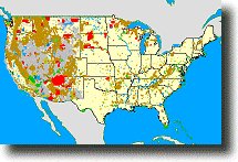
 Each map layer was created by extracting federal land polygon features from the individual 1:2,000,000-scale State boundary Digital Line Graph (DLG) files produced by the U.S. Geological Survey. These files were then appended into a single coverage. Individual layers (above) were extracted from this coverage. (Source: USGS).
About Quality, Accuracy and Suitability
This data may come from a variety of U.S.
government and self-reporting private
sources. While we try to assure the accuracy of
this material, we cannot promise that it is
absolutely accurate. We do promise that using the
map layer will be fun, entertaining or educational.
Beyond this, we make no guarantee as to its
suitability for any purpose. We assume no liability
or responsibility for errors or inaccuracies. Please
understand that you use these map layers and data at your own
risk.
Thank You,
Didn't find what you are looking for? We've been online since 1996 and have created 1000's of pages. Search below and you may find just what you are looking for.
Michael R. Meuser
Data Research & GIS Specialist
MapCruzin.com is an independent firm
specializing in GIS project development and data research.
We created the first U.S. based
interactive toxic chemical facility
maps on the internet in 1996 and we
have been online ever since. Learn more about us and our services.
Have a project in mind? If you have data, GIS project or custom shapefile needs contact Mike.
Contact Us
Report Broken Links
Subscribe for Updates
See also:
Free TRI Pollution Maps
Free Learn2Map GIS Tutorial and Atlas


 Coverage: All U.S. including Hawaii and Alaska.
 Recently updated Summer 2008 maps
 National Park Service (NPS) (