GIS Mapping, Education and Research
Home   Free GIS   Shapefiles   Mobile   Weather   Energy   News   Maps   TOPO   Aerial   GPS   Learn GIS   D.I.Y.

FREE UPDATES
Enter your e-mail


Indian & Federal Lands ArcGIS Shapefiles - BIA, NPS, DOE, DOD, FWS, NPS, USFS ... more

Featured GIS Shapefile Map Layers - for Beginners & Experienced GIS Users Alike. Zip Code Boundaries, School Districts, Indian & Federal Lands, Climate Change, Tornadoes, Dams - Create digital GIS maps in minutes ... more

Follow Mapcruzin.com on Twitter
Follow on Twitter

Online GIS Certicates, Degrees, Diplomas - Distance Learning

ALL, American Sentinel University, Birkbeck, City University London, Curtin University GIS Certificate, Curtin University Graduate Diploma, Curtin University M.S., DePaul University, Eastern Michigan University, Elmhurst College, Emporia State University, GIS Certification Institute, John Hopkins University, Northwest Missouri State, Penn State, Purdue, Roosevelt University, UNIGIS Network, University of Colorado, University of Denver, University of Leeds, University of Montana, University of North Dakota, University of Southern California, URISA, Vancouver Island University, ALL

A Member of the
Reimagination Network

Didn't find what you are looking for? Email me and I'll find it for you.

Progressive Links

Federation of American Scientists

Physicians for Social Responsibility

Public Employees for Environmental Responsibility

Union of Concerned Scientists

Alternet

Reader Supported News

Common Dreams

Truthout

Huffington Post

Media Matters

Think Progress

Grist Environmental News

Have a question or comment? Post them at the MapCruzin Blog.

Climate Shift Blog

MapCruzin Consulting
GIS and Google Maps Development, Website Creation and Hosting, Fast and Affordable.

Partners
HomeGrownSolution.com, Maptivist.com, JoyOfRailroading.com, Climate Shift, Recycle, Reuse & Salvage, Climate Injustice, Blue Creek - Ah Pah, Right Livelihoods, Reimagination, Indian Valley Retreat

GIS Tutorials

GIS Basics

GIS Terminology

Of Interest

Home Based Recycling Business - Free resources and tools.

Joy of Railroading - Model and prototype news, resources, photos.

Reimagination - Reimagining, exploring and celebrating the changes in infrastructure, politics and culture that will help us live in harmony with each other and the earth now and in the future.

Arctic National Wildlife Refuge

Climate Shift - The effects of climate shift on the future of planet earth and its inhabitants.

Right to Know or Left to Wonder?

Tools for Survival

Hazardscapes - Toxic and Nuclear Risks in your backyard.

War & Environment

Worst Case Scenarios: Terrorism & industrial chemicals.

Redwood Ecotours: Explore California's Redwood North Coast.


poets against the war

Right To Know Network - environmental information and databases

Viewable with ANY browser

Subscribe for Updates


Free U.S. Nuclear Reactor Power Plant, Seismic Hazard and Historical Earthquakes ArcGIS Shapefile Maps, Images in TIF, PNG and PDF Formats

<-- All Things Nuclear
<-- Geospatial Data Shapefile Downloads

Can a Fukushima like nuclear accident happen in the United States?

Yesterday I asked the question, "How many nuclear reactors are there in the United States?" I asked this because after Greenpeace.org published my maps and download link on their blog, a person commented that there are 104 nuclear power plants in the U.S. not 63 as the blog said. At first I figured the confusion came about because some facilities have multiple reactors, but the numbers still didn't add up. As I looked into it further I was becoming increasingly dismayed because every data set I looked at was a bit different - facilities on one list didn't appear on others.

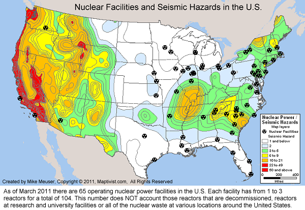
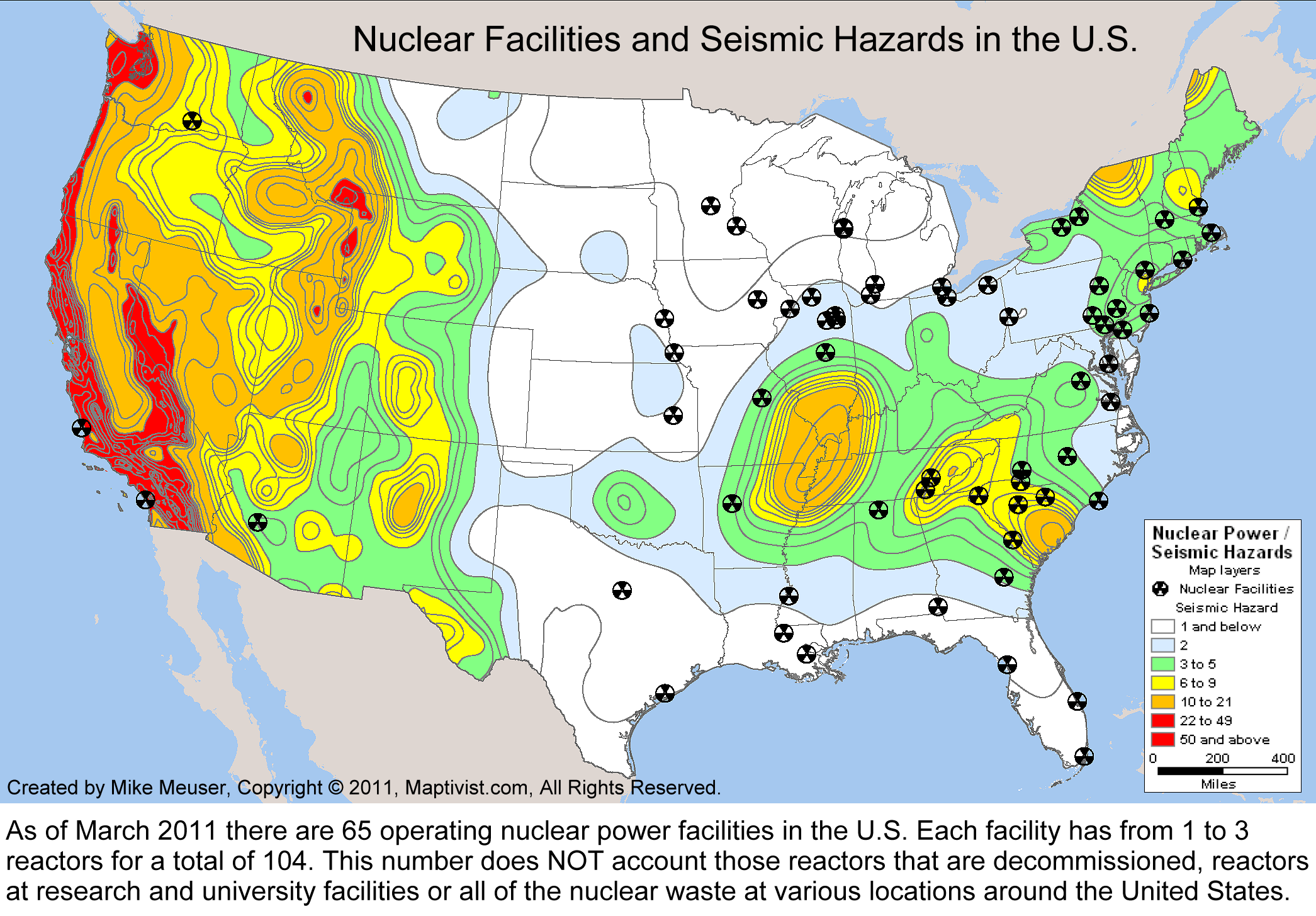
After examining lists in various reports and at government and NGO websites, I've determined that as of March 2011 there are 65 operating nuclear power facilities in the U.S. Each facility has from 1 to 3 reactors for a total of 104. This number does NOT account for those reactors that are decommissioned, reactors at research and university facilities or all of the nuclear waste at various locations around the United States. In time, I will make shapefiles available of these other nuclear hazards. See below for new maps, an updated nuclear and seismic hazards shapefile and spreadsheet that you may download and use as you wish.

How many nuclear reactors are there in the United States? A few people have noted that their only appears to be around 63 nuclear power plants on the map, yet, they say, there should be 104. At first I thought they were confused because many of the nuclear power plant facilities have more than one reactor. Some have as many as 3. So, I checked with the NRC and found 2 different lists that had 64 plants and 103 reactors, but the lists were not identical. A few plants appearing on one list, did not appear on the other. So, to get at the bottom of this and find the most current list of operating nuclear power plants in the U.S. I am going to compare the two NRC lists with those from Nukeworker.org, IEA and the World Nuclear Association and come up with THE list.

Note that if you look at the current spreadsheet or shapefile that you may download from this page, you will find several other types of nuclear related facilities besides Nuclear Power Plants. In the future, I'd like to also list and document all the non-energy related reactors that are in operation at national laboratories, universities, hospitals, research firms and elsewhere. Beyond that it is also important to document decommissioned nuclear power plants and other places that nuclear waste is currently stored.


These ArcGIS shapefiles are derived from U.S. Government data sources. Layered together they show the proximity of nuclear reactors in the United States with historical earthquakes. They also show proximity to seismic hazard zones. Each shapefile set includes detailed source and data information in a metadata file. Features include Power Plant, Fuel Cycle Licensee, Material Licensee, Site Decommissioning, Uranium Mill Site, High Level Waste, and Independent Spent Fuel Storage Installation. You may download an updated spreadsheet listing these nuclear facilities and their locations

I have provided some sample maps. I created these with Maptitude GIS. If you are new to GIS, check out our Learn2Map GIS Tutorial and Atlas, learn more and download a free GIS program that you can use to make your own maps with these shapefiles.

You may also download basemap shapefiles of cities, roads, water features, etc. of the United States. Click here to skip to the download section.

nuclear facilities and seismic hazards
Nuclear Facilities and Seismic Hazard Zones

historical earthquakes in the U.S.
Nuclear Facilities and Historical U.S. Earthquakes

nuclear facilities
Nuclear Facilities in the United States

seismic hazards
U.S. Seismic Hazard Zones

Download the Shapefiles and Spreadsheet

Updated Nuclear Reactor Facilities Shapefile
Seismic Hazards Shapefile
Historical Earthquakes Shapefile
U.S. Basemaps Shapefile
Updated Nuclear Facility Spreadsheet
Medium PNG Image
Large PNG Image
Large TIF Image
Acrobat PDF Image

If you require print quality maps or custom shapefiles of any sort, please contact me.

<-- All Things Nuclear
<-- Geospatial Data Shapefile Downloads


MapCruzin.com is an independent firm specializing in the publication of educational and research resources. We created the first U.S. based interactive toxic chemical facility maps on the internet in 1996 and we have been online ever since. Learn more about us and view some of our projects and services.

If you have data, GIS project or custom shapefile needs send me an email.

Contact Us

Report Broken Links

Subscribe for Updates

Didn't find what you are looking for? We've been online since 1996 and have created 1000's of pages. Search below and you may find just what you are looking for.

Find: Maps, Shapefiles, GIS Software & More

MapCruzin Blog for updates, questions and answers

Free GIS Resources

U.S. Nuclear Reactors and Seismic Hazards Shapefiles, Free GIS Software, ArcGIS shapefiles, GIS Degree Certificate Online, World ArcGIS Shapefiles, Learn2Map GIS Tutorial and Atlas, State GIS Shapefiles, U.S. Boundary Shapefiles, Open GIS Shapefiles, GIS Jobs & Training, U.S. State GIS Resources Census Tiger Line Shapefiles, National Transportation Shapefiles, Free Wireless ArcGIS Shapefiles, Mexico, Canada, U.S. Shapefiles, TOPO and Terrain Maps, GPS Resources and Tutorials, Free GIS & Geospatial Programs, Google Earth and Google Maps mashups, resources, maps and tools, EPA Geospatial Shapefiles, GeoData, National Geodetic Survey Software, MrSid, JPEG2000 and GeoTIFF Maps, Satellite Aerial Photos, TRI National Analysis Data, Shapefiles, Toxic Maps with Google

Downloads

Google Earth Toxic Release Inventory (TRI) Maps
Lester Brown's Plan B 3.0
State GIS Shapefiles, Maps & Resources
GIS Shapefiles & Maps
GIS Programs, Tools & Resources
Free World Country & Regional Maps
GIS / GPS Careers and Job Positions
Disease Outbreak Maps
TOPO Maps
Extreme Weather & Disaster Maps
Free World Maps from the CIA Factbook
Arctic National Wildlife Refuge ANWR Maps
Oil and Gas Maps
Africanized Honey Bees
Renewable Energy Potential Maps of the United States
Terrorism Maps
War Maps
Google Maps
Weather Maps
GPS Resources
Historical Maps of the World
Google Earth
Library of Congress American Memory Map Downloads
Toxic Chemical Pollution Maps
Climate Change Maps
Toxic Release Inventory (TRI) Maps
Census Shapefiles
World Maps

Issues

Environmental Justice
Data Sources
Greenwash & JunkScience
Statistical Resources
Wireless Dangers
Surviving Climate Change
Global Right-To-Know
Creating Living Economies
Books of Note
Toxic Klamath River
Federal Lands Maps
TRI Analysis
TRI Webmaps
EnviroRisk Map Network
Community-Based Research
Right-To-Know or Left to Wonder?
Chemical Industry Archives
21st Century Warfare
Biotechnology
Nanotechnology
Globalization/Democracy
National Parks and Public Lands
Trade Secrets/Toxic Deception
GIS Books
Our Projects
Other Projects
1999 Archive Environews
Environmental Books
Environmental Links
Redwood Coast Information
Recycle, Salvage, Reuse

Resources
Maptivist.com
ToolsForSurvival.com
ClimateShift.com
RecyclingSecrets.com
ToxicRisk.com
Learn2Map.com
RightLivelihoods.com

About MapCruzin - Privacy, Fair Use and Disclaimer - Advertise on MapCruzin.com

Home | Free GIS | Downloads | Parks & Public Lands | Books | Environmental Justice | News Archives
Free GIS Tutorial | Consulting | TRI 2004 MAPS | Recycle Reuse Business | Toxics Explorer
North Coast GIS | Contact/About Us | Redwood Ecotours | Global Positioning | EnviroRisk Map Network
Climate Collapse | Free GIS Tutorial | What is GIS? | Right to Know | Reimagination | Health & GIS | Shrubbed | Search

Website development and hosting provided by Michael Meuser

Copyright © 1996 - 2012 Michael Meuser, All Rights Reserved
MapCruzin is a Pop-Up Free Website -- Best Viewed With ANY Browser

tumblr page counter