GIS Mapping, Education and Research
Home   Free GIS   Shapefiles   Mobile   Weather   Energy   News   Maps   TOPO   Aerial   GPS   Learn GIS   D.I.Y.

FREE UPDATES
Enter your e-mail


U.S. School Distric Shapefiles - Elementary, Secondary and Unified School Districts ... more

Featured GIS Shapefile Map Layers - for Beginners & Experienced GIS Users Alike. Zip Code Boundaries, School Districts, Indian & Federal Lands, Climate Change, Tornadoes, Dams - Create digital GIS maps in minutes ... more

Follow Mapcruzin.com on Twitter
Follow on Twitter

Online GIS Certicates, Degrees, Diplomas - Distance Learning

ALL, American Sentinel University, Birkbeck, City University London, Curtin University GIS Certificate, Curtin University Graduate Diploma, Curtin University M.S., DePaul University, Eastern Michigan University, Elmhurst College, Emporia State University, GIS Certification Institute, John Hopkins University, Northwest Missouri State, Penn State, Purdue, Roosevelt University, UNIGIS Network, University of Colorado, University of Denver, University of Leeds, University of Montana, University of North Dakota, University of Southern California, URISA, Vancouver Island University, ALL

A Member of the
Reimagination Network

Didn't find what you are looking for? Email me and I'll find it for you.

Progressive Links

Federation of American Scientists

Physicians for Social Responsibility

Public Employees for Environmental Responsibility

Union of Concerned Scientists

Alternet

Reader Supported News

Common Dreams

Truthout

Huffington Post

Media Matters

Think Progress

Grist Environmental News

Have a question or comment? Post them at the MapCruzin Blog.

Climate Shift Blog

MapCruzin Consulting
GIS and Google Maps Development, Website Creation and Hosting, Fast and Affordable.

Partners
HomeGrownSolution.com, Maptivist.com, JoyOfRailroading.com, Climate Shift, Recycle, Reuse & Salvage, Climate Injustice, Blue Creek - Ah Pah, Right Livelihoods, Reimagination, Indian Valley Retreat

GIS Tutorials

GIS Basics

GIS Terminology

Of Interest

Home Based Recycling Business - Free resources and tools.

Joy of Railroading - Model and prototype news, resources, photos.

Reimagination - Reimagining, exploring and celebrating the changes in infrastructure, politics and culture that will help us live in harmony with each other and the earth now and in the future.

Arctic National Wildlife Refuge

Climate Shift - The effects of climate shift on the future of planet earth and its inhabitants.

Right to Know or Left to Wonder?

Tools for Survival

Hazardscapes - Toxic and Nuclear Risks in your backyard.

War & Environment

Worst Case Scenarios: Terrorism & industrial chemicals.

Redwood Ecotours: Explore California's Redwood North Coast.


poets against the war

World View of Global Warming

The Southern Poverty Law Center

Recycling today magazine

Viewable with ANY browser

Subscribe for Updates


Natural Disaster Series: Download free Volcano GIS Shapefile

<-- Download ArcGIS Shapefiles
<-- More Natural Disaster Shapefiles

See Also:
New to GIS? Read about it here and learn the basics with our free Learn2Map GIS Tutorial and Atlas.

View Metadata
Download the Volcano Shapefile

Analyzing contemporary volcanic activity with historical and geological records of the recent past provides the context for assessing any volcano's benefits and dangers. The Global Volcanism Program (GVP) seeks better understanding of all volcanoes through documenting their eruptions during the last 10,000 years. The large and growing Volcanoes of the World database developed by the GVP contains the geographic, historical, and volcanological characteristics of nearly 3,000 active volcanoes around the world. The GVP works in close collaboration with scientists and organizations concerned with volcano hazards, airline safety, geothermal energy, and global climate change. The database is used in research projects and for answering questions on volcanology from other scientists, the media, and the public. The GVP is part of the National Museum of Natural History at the Smithsonian Institution.

The National Atlas of the United States® extracted the information for this map layer from the Volcanoes of the World database 
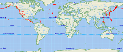
described above. The map layer features volcanoes in an extended area of the northern hemisphere centered on North America. Descriptive information includes the name of the volcano, the timeframe of the last known eruption, the summit elevation, the type of volcano as described by its shape and size, and the type of evidence used to determine volcanic activity. The National Atlas also includes a multimedia map showing potentially active volcanoes in the United States. Further volcano information can be found on the U.S. Geological Survey

View Metadata
Download the Volcano Shapefile

See Also:
New to GIS? Read about it here and learn the basics with our free Learn2Map GIS Tutorial and Atlas.

<-- Download ArcGIS Shapefiles
<-- More Natural Disaster Shapefiles

About Quality, Accuracy and Suitability

This data may come from a variety of U.S. government and self-reporting private sources. While we try to assure the accuracy of this material, we cannot promise that it is absolutely accurate. We do promise that using the map layer will be fun, entertaining or educational. Beyond this, we make no guarantee as to its suitability for any purpose. We assume no liability or responsibility for errors or inaccuracies. Please understand that you use these map layers at your own risk.


MapCruzin.com is an independent firm specializing in the publication of educational and research resources. We created the first U.S. based interactive toxic chemical facility maps on the internet in 1996 and we have been online ever since. Learn more about us and view some of our projects and services.

If you have data, GIS project or custom shapefile needs send me an email.

Contact Us

Report Broken Links

Subscribe for Updates

Didn't find what you are looking for? We've been online since 1996 and have created 1000's of pages. Search below and you may find just what you are looking for.

Find: Maps, Shapefiles, GIS Software & More

MapCruzin Blog for updates, questions and answers

Free GIS Resources

U.S. Nuclear Reactors and Seismic Hazards Shapefiles, Free GIS Software, ArcGIS shapefiles, GIS Degree Certificate Online, World ArcGIS Shapefiles, Learn2Map GIS Tutorial and Atlas, State GIS Shapefiles, U.S. Boundary Shapefiles, Open GIS Shapefiles, GIS Jobs & Training, U.S. State GIS Resources Census Tiger Line Shapefiles, National Transportation Shapefiles, Free Wireless ArcGIS Shapefiles, Mexico, Canada, U.S. Shapefiles, TOPO and Terrain Maps, GPS Resources and Tutorials, Free GIS & Geospatial Programs, Google Earth and Google Maps mashups, resources, maps and tools, EPA Geospatial Shapefiles, GeoData, National Geodetic Survey Software, MrSid, JPEG2000 and GeoTIFF Maps, Satellite Aerial Photos, TRI National Analysis Data, Shapefiles, Toxic Maps with Google

Downloads

Google Earth Toxic Release Inventory (TRI) Maps
Lester Brown's Plan B 3.0
State GIS Shapefiles, Maps & Resources
GIS Shapefiles & Maps
GIS Programs, Tools & Resources
Free World Country & Regional Maps
GIS / GPS Careers and Job Positions
Disease Outbreak Maps
TOPO Maps
Extreme Weather & Disaster Maps
Free World Maps from the CIA Factbook
Arctic National Wildlife Refuge ANWR Maps
Oil and Gas Maps
Africanized Honey Bees
Renewable Energy Potential Maps of the United States
Terrorism Maps
War Maps
Google Maps
Weather Maps
GPS Resources
Historical Maps of the World
Google Earth
Library of Congress American Memory Map Downloads
Toxic Chemical Pollution Maps
Climate Change Maps
Toxic Release Inventory (TRI) Maps
Census Shapefiles
World Maps

Issues

Environmental Justice
Data Sources
Greenwash & JunkScience
Statistical Resources
Wireless Dangers
Surviving Climate Change
Global Right-To-Know
Creating Living Economies
Books of Note
Toxic Klamath River
Federal Lands Maps
TRI Analysis
TRI Webmaps
EnviroRisk Map Network
Community-Based Research
Right-To-Know or Left to Wonder?
Chemical Industry Archives
21st Century Warfare
Biotechnology
Nanotechnology
Globalization/Democracy
National Parks and Public Lands
Trade Secrets/Toxic Deception
GIS Books
Our Projects
Other Projects
1999 Archive Environews
Environmental Books
Environmental Links
Redwood Coast Information
Recycle, Salvage, Reuse

Resources
Maptivist.com
ToolsForSurvival.com
ClimateShift.com
RecyclingSecrets.com
ToxicRisk.com
Learn2Map.com
RightLivelihoods.com

About MapCruzin - Privacy, Fair Use and Disclaimer - Advertise on MapCruzin.com

Home | Free GIS | Downloads | Parks & Public Lands | Books | Environmental Justice | News Archives
Free GIS Tutorial | Consulting | TRI 2004 MAPS | Recycle Reuse Business | Toxics Explorer
North Coast GIS | Contact/About Us | Redwood Ecotours | Global Positioning | EnviroRisk Map Network
Climate Collapse | Free GIS Tutorial | What is GIS? | Right to Know | Reimagination | Health & GIS | Shrubbed | Search

Website development and hosting provided by Michael Meuser

Copyright © 1996 - 2012 Michael Meuser, All Rights Reserved
MapCruzin is a Pop-Up Free Website -- Best Viewed With ANY Browser

tumblr page counter