Free National Atlas One Million-Scale Shapefile to Download and Use as You Please
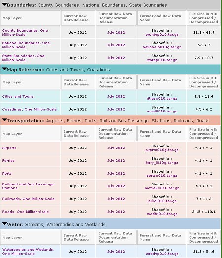
The National Atlas team recently released new more detailed one million-scale shapefiles. So far the set includes boundaries (county, state and national), map reference (cities, towns and coastlines), transportation (airports, ferries, ports, rail and bus stations, railroads and roads), and water (streams, waterbodies and wetlands). They'll be adding more in the future.

You can download the new one million-scale shapefiles here.
About Shapefiles - Accuracy, Quality and Suitability
Thanks,
Didn't find what you are looking for? We've been online since 1996 and have created 1000's of pages. Search below and you may find just what you are looking for.
Michael R. Meuser
Data Research & GIS Specialist
MapCruzin.com is an independent firm
specializing in GIS project development and data research.
We created the first U.S. based
interactive toxic chemical facility
maps on the internet in 1996 and we
have been online ever since. Learn more about us and our services.
Have a project in mind? If you have data, GIS project or custom shapefile needs contact Mike.
Contact Us
Report Broken Links
Subscribe for Updates
Sponsors


