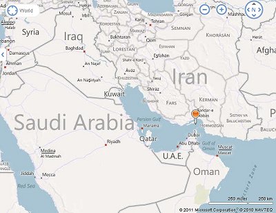
Sanctions on Iran Results in Iran blockading Strait of Humoz Reducing Fuel Flow from Middle East. Will This Fuel the Fire for U.S. Oil, Gas and Nuclear Energy?
Sponsors
<-- GIS News
<-- Free Energy Maps & Shapefiles
It looks like were drawing ever closer to a war with Iran even though it is not clear at all whether or not Iran is actually building nuclear weapons. In response to increasing U.S. and European sanctions, Iran has threatened to blockade the Strait of Humoz. Around 13 loaded oil tankers travel through the Straits of Humoz each day. Oil and gas prices are already very high. What will this mean for the future? Perhaps those in the U.S. that are pushing for the Keystone XL project, drilling in the Arctic, fracking for natural gas, wrongly pushing for nuclear as a sustainable alternative and blowing off the tops of mountains for coal will see the threat of less oil flowing from the Middle East as a good thing. It will surely provide fuel for the fire of domestic oil, gas and nuclear energy production. Too bad that it won't, instead, fuel the fire for solar and other alternative energy technologies in the U.S. - the real solution to increasing domestic energy production, creating high paying jobs here in the U.S.

Here's a description from Wikipedia
The Strait of Hormuz is a narrow, strategically important strait between the Gulf of Oman in the southeast and the Persian Gulf. On the north coast is Iran and on the south coast is the United Arab Emirates and Musandam, an exclave of Oman.
The strait at its narrowest is 54 kilometres (34 mi) wide.[1] It is the only sea passage to the open ocean for large areas of the petroleum-exporting Persian Gulf. About 13 tankers carrying 15.5 million barrels (2,460,000 m3) of crude oil pass through the strait on an average day, making it one of the world's most strategically important choke points. This represents 33% of the world's seaborne oil shipments, and 17% of all world oil shipments in 2009.[2]...Read more at Wikipedia.
Iran Threatens to Blockade Strait of Humoz
Source: Truthout
As US Readies Sanctions, Iran Threatens to Block Oil Route
Wednesday 28 December 2011
by: David E. Sanger, The New York Times News Service | Report
Washington - A senior Iranian official on Tuesday delivered a sharp threat in response to economic sanctions being readied by the United States, saying his country would retaliate against any crackdown by blocking all oil shipments through the Strait of Hormuz, a vital artery for transporting about one-fifth of the world�s oil supply.
The declaration by Iran�s first vice president, Mohammad-Reza Rahimi, came as President Obama prepares to sign legislation that, if fully implemented, could substantially reduce Iran�s oil revenue in a bid to deter it from pursuing a nuclear weapons program.
Sponsors
Prior to the latest move, the administration had been laying the groundwork to attempt to cut off Iran from global energy markets without raising the price of gasoline or alienating some of Washington�s closest allies.
Apparently fearful of the expanded sanctions� possible impact on the already-stressed economy of Iran, the world�s third-largest energy exporter, Mr. Rahimi said, �If they impose sanctions on Iran�s oil exports, then even one drop of oil cannot flow from the Strait of Hormuz,� according to Iran�s official news agency. Iran just began a 10-day naval exercise in the area.
In recent interviews, Obama administration officials have said that the United States has developed a plan to keep the strait open in the event of a crisis. In Hawaii, where President Obama is vacationing, a White House spokesman said there would be no comment on the Iranian threat to close the strait. That seemed in keeping with what administration officials say has been an effort to lower the level of angry exchanges, partly to avoid giving the Iranian government the satisfaction of a response and partly to avoid spooking financial markets.
But the energy sanctions carry the risk of confrontation, as well as economic disruption, given the unpredictability of the Iranian response. Some administration officials believe that a plot to assassinate the Saudi ambassador to the United States � which Washington alleges received funding from the Quds Force, part of the Iranian Revolutionary Guards Corps � was in response to American and other international sanctions...Read more at Truthout
Related
Download IAEA Report: IAEA Claimed Iran "Weapons Expert" Never Actually Worked on Nuclear Weapons At All
World Energy Requirements Can Be Met With Renewables
Download free Iran maps
Download Free Oil and Gas Reserves, Production and Exploration Maps
Free Iran Country, Cities and Places GIS Shapefile Map Layers
Download Free World Ethnicity & Religion Maps
Download Free Middle East Country Atlas Maps
Sponsors
<-- GIS News
<-- Free Energy Maps & Shapefiles
Didn't find what you are looking for? We've been online since 1996 and have created 1000's of pages. Search below and you may find just what you are looking for.
Michael R. Meuser
Data Research & GIS Specialist
MapCruzin.com is an independent firm
specializing in GIS project development and data research.
We created the first U.S. based
interactive toxic chemical facility
maps on the internet in 1996 and we
have been online ever since. Learn more about us and our services.
Have a project in mind? If you have data, GIS project or custom shapefile needs contact Mike.
Contact Us
Report Broken Links
Subscribe for Updates


