Batik Java Based Toolkit for Scalable Vector Graphics (SVG)
Sponsors
<-- Free GIS Software & Resources
See Also:
Free ArcGIS Shapefiles, Free Maps, Google Earth & Maps, Free GPS, Satellite and Aerial, GIS Tutorials.
Batik is a Java-based toolkit for applications or applets that want to use images in the Scalable Vector Graphics (SVG) format for various purposes, such as display, generation or manipulation.
The project's ambition is to give developers a set of core modules that can be used together or individually to support specific SVG solutions. Examples of modules are the SVG Parser, the SVG Generator and the SVG DOM. Another ambition for the Batik project is to make it highly extensible�for example, Batik allows the developer to handle custom SVG elements. Even though the goal of the project is to provide a set of core modules, one of the deliverables is a full fledged SVG browser implementation which validates the various modules and their inter-operability.
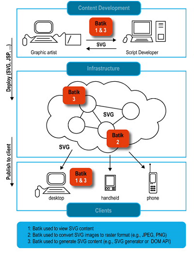
What Batik can be used for
Batik use cases With Batik, you can manipulate SVG documents anywhere Java is available. You can also use the various Batik modules to generate, manipulate and transcode SVG images in your applications or applets.
Batik makes it easy for Java based applications or applets to deal with SVG content. For example, using Batik's SVG generator module, a Java application or applet can very easily export its graphics into the SVG format. Using Batik's SVG viewing component, an application or applet can very easily integrate SVG viewing and interaction capabilities. Another possibility is to use Batik's modules to convert SVG to various formats, such as raster images (JPEG, PNG or TIFF) or other vector formats (EPS or PDF, the latter two due to the transcoders provided by Apache FOP).
Visit the Batik Website.
Sponsors
<-- Free GIS Software & Resources
See Also:
Free ArcGIS Shapefiles, Free Maps, Google Earth & Maps, Free GPS, Satellite and Aerial, GIS Tutorials.
Didn't find what you are looking for? We've been online since 1996 and have created 1000's of pages. Search below and you may find just what you are looking for.
Michael R. Meuser
Data Research & GIS Specialist
MapCruzin.com is an independent firm
specializing in GIS project development and data research.
We created the first U.S. based
interactive toxic chemical facility
maps on the internet in 1996 and we
have been online ever since. Learn more about us and our services.
Have a project in mind? If you have data, GIS project or custom shapefile needs contact Mike.
Contact Us
Report Broken Links
Subscribe for Updates


