Long-Term U.S. Tornado Climatology Report
<-- Return to: Extreme Weather Natural Disaster
Source: NOAA/NCDC
Introduction
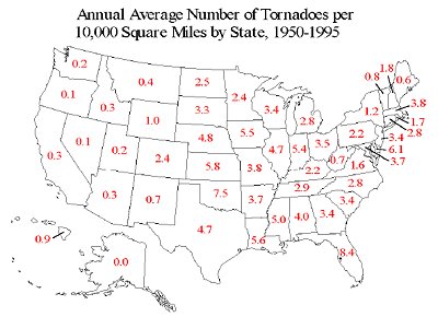
This report provides long-term climatological summaries and maps for tornadoes in the United States, with specific information concerning tornadoes during 1998-1999. The years 1998 and 1999 were quite active for tornadoes in the U.S., with well-above average numbers of fatalities. It is interesting to note that the winter-spring of 1998 was dominated by El Nino conditions, while the winter-spring of 1999 was dominated by La Nina, thus showing that active tornado seasons may occur in either situation. However, the 1998 season was much more active in the southeast, while 1999 saw a shift of activity farther west--very much as expected. Also, these 2 years produced a total of 3 tornadoes of F5 intensity and 11 tornadoes of F4 intensity, for a total of 14 in the violent F4-F5 category.
Download the full report in PDF format
Sponsors
Related Resources
U.S. Tornadoes from 1950 through 2008 Download
Natural Disaster ArcGIS Shapefile Map Layer Series
Extreme Weather, Natural Disaster, Weather Warning, Climate Change Maps, GIS Shapefiles & Resources
About Quality, Accuracy and Suitability
This data may come from a variety of U.S. government and self-reporting private sources. While we try to assure the accuracy of this material, we cannot promise that it is absolutely accurate. We do promise that using the map layer will be fun, entertaining or educational. Beyond this, we make no guarantee as to its suitability for any purpose. We assume no liability or responsibility for errors or inaccuracies. Please understand that you use these map layers at your own risk.
Didn't find what you are looking for? We've been online since 1996 and have created 1000's of pages. Search below and you may find just what you are looking for.
Michael R. Meuser
Data Research & GIS Specialist
MapCruzin.com is an independent firm
specializing in GIS project development and data research.
We created the first U.S. based
interactive toxic chemical facility
maps on the internet in 1996 and we
have been online ever since. Learn more about us and our services.
Have a project in mind? If you have data, GIS project or custom shapefile needs contact Mike.
Contact Us
Report Broken Links
Subscribe for Updates


