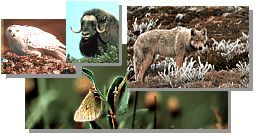 
Refuge Information | Wildlife | Habitat | People
Home | New | Feedback | Index | Search
Why we archived the ANWR website at MapCruzin.com
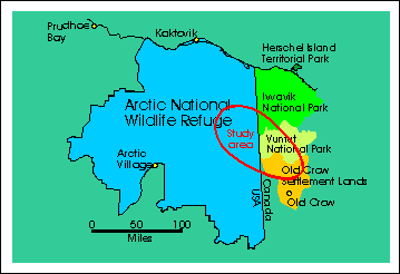
Where do the moose go?... Solving a Moose Migration Mystery
For years, Refuge visitors and staff noticed that moose came into the mountain valleys in the
eastern portion of the Arctic Refuge each fall, and disappeared again each spring. Where the
moose spent the summer was a mystery. Meanwhile, the Vuntut Gwitchin Indians of Old
Crow village in northern Canada had a mystery of their own. They knew that moose came to
Old Crow Flats in late spring, but wondered where they disappeared to in the winters.
In March of 1995, Refuge staff began working with the Vuntut Gwitchin when a new
wildlife migration was discovered between the Arctic Refuge in Alaska, and the Indians' land in
the Old Crow Flats area. This web page tells the story behind this new discovery.
Our story begins long before there was an international border between the United States and
Canada. It was a time when people and wildlife moved freely across the land in response to the
weather and the seasons.
 After the melting of the continental ice sheet
some 10,000 years ago, the Old Crow Flats area became a huge melt-water lake. Eventually, the
lake broke open, carving the ramparts of the Porcupine River. The thick deposit of silt that had
settled on the lake bottom now contributed to the formation of rich soils across the Flats. In the
Brooks Range mountains of Alaska, glaciers also retreated, leaving deep, protected valleys in
their wake. After the melting of the continental ice sheet
some 10,000 years ago, the Old Crow Flats area became a huge melt-water lake. Eventually, the
lake broke open, carving the ramparts of the Porcupine River. The thick deposit of silt that had
settled on the lake bottom now contributed to the formation of rich soils across the Flats. In the
Brooks Range mountains of Alaska, glaciers also retreated, leaving deep, protected valleys in
their wake.
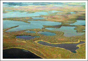 A system of thaw-lakes and wetlands developed
on the emptied lake bottom, and a rich diversity of tundra, shrub, and forest vegetation became
established. Along with the plants came a great variety of wildlife (muskrats, beaver, ducks,
geese, swans, loons, and many other birds, caribou, bears, wolves, wolverines, and moose). A system of thaw-lakes and wetlands developed
on the emptied lake bottom, and a rich diversity of tundra, shrub, and forest vegetation became
established. Along with the plants came a great variety of wildlife (muskrats, beaver, ducks,
geese, swans, loons, and many other birds, caribou, bears, wolves, wolverines, and moose).
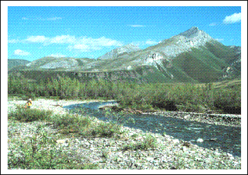 At the same time, stands of willows began to grow
in the empty valleys of the Brooks Range to the northwest. At the same time, stands of willows began to grow
in the empty valleys of the Brooks Range to the northwest.
In 1995, a study was initiated by Fran Mauer, a biologist with the Arctic Refuge, to try to
find out where the moose in the eastern portion of the Refuge were going each summer.
The Arctic Refuge Moose Study Objectives were:
- Determine seasonal movements and distribution of moose
- Determine fidelity (whether they returned to the same place year after year) of individual
moose to winter concentrations
- Assess relationship of moose concentrations to regional moose populations and human
harvest
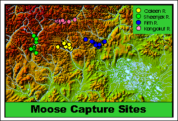 In late March and early April, 1995, 57 moose
were captured and equipped with radio- collars. 15 moose were collared along each of three
Refuge rivers: the Sheenjek (green circles), Coleen (yellow circles), and Firth (blue circles); and
12 were collared in the Kongakut River area (pink circles). In late March and early April, 1995, 57 moose
were captured and equipped with radio- collars. 15 moose were collared along each of three
Refuge rivers: the Sheenjek (green circles), Coleen (yellow circles), and Firth (blue circles); and
12 were collared in the Kongakut River area (pink circles).
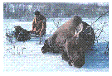 Biologists immobilized the moose
using standard dart/drug techniques. The moose were handled carefully, and all animals
survived these capture activities. Biologists immobilized the moose
using standard dart/drug techniques. The moose were handled carefully, and all animals
survived these capture activities.
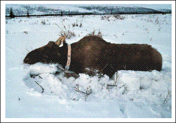 Each moose was examined and measured to
find out how healthy it was. Blood, hair, and pellet samples were collected. A small hole-
punched circle was removed from the ear for moose genetics (DNA) research at the University of
Alaska. A colored ear tag was installed so the moose could be more easily spotted again in the
field. A radio collar was placed around each animal's neck. These collars send out radio signals
that help biologists relocate moose. The radio-collar will provide signals for up to 4 years. Each moose was examined and measured to
find out how healthy it was. Blood, hair, and pellet samples were collected. A small hole-
punched circle was removed from the ear for moose genetics (DNA) research at the University of
Alaska. A colored ear tag was installed so the moose could be more easily spotted again in the
field. A radio collar was placed around each animal's neck. These collars send out radio signals
that help biologists relocate moose. The radio-collar will provide signals for up to 4 years.
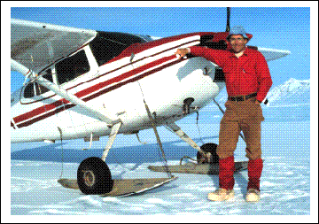 Because the moose move across a wide region of
mountians and rivers, biologists flew in small airplanes to search for the animals in the study.
This Cessna 185 was equipped with tracking antennas and a special radio receiver that picked up
the sounds from each moose collar. The biologist and pilot used these signals to relocate each
moose. Because the moose move across a wide region of
mountians and rivers, biologists flew in small airplanes to search for the animals in the study.
This Cessna 185 was equipped with tracking antennas and a special radio receiver that picked up
the sounds from each moose collar. The biologist and pilot used these signals to relocate each
moose.
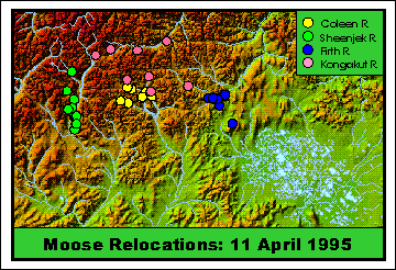 By mid April, moose were moving from the
Kongakut River area (most northern capture site), and some of the Sheenjek River moose had
moved south down the Sheenjek River valley. By mid April, moose were moving from the
Kongakut River area (most northern capture site), and some of the Sheenjek River moose had
moved south down the Sheenjek River valley.
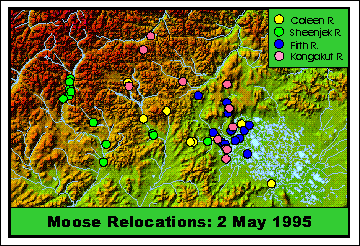 In early May, many moose were moving to
the south and east. Some had already arrived in Old Crow Flats. In early May, many moose were moving to
the south and east. Some had already arrived in Old Crow Flats.
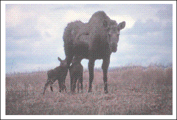
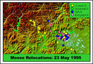 By the end of May, many moose had arrived in
Old Crow Flats. Moose calves are born at about this time, so most young were born in Canada. By the end of May, many moose had arrived in
Old Crow Flats. Moose calves are born at about this time, so most young were born in Canada.
 During this study, 75% of the moose collared in
Alaska migrated to Old Crow Flats. Most moose remained in Old Crow Flats during the
summer. During this study, 75% of the moose collared in
Alaska migrated to Old Crow Flats. Most moose remained in Old Crow Flats during the
summer.
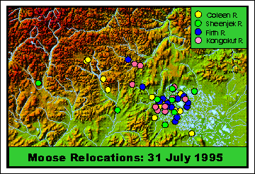
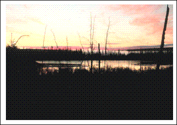
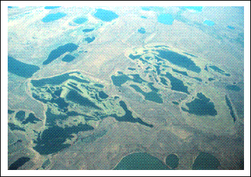 Old Crow Flats are ideal summer habitat for
moose. There are many shallow lakes and ponds with aquatic vegetation (plants that grow in
water), a common food item for moose during summer. In addition, there are several partially
drained lake basins which have lots of aquatic vegetation as well as willows, another important
food item for moose. Old Crow Flats are ideal summer habitat for
moose. There are many shallow lakes and ponds with aquatic vegetation (plants that grow in
water), a common food item for moose during summer. In addition, there are several partially
drained lake basins which have lots of aquatic vegetation as well as willows, another important
food item for moose.
 According to data collected during this study,
moose begin moving out of the Old Crow Flats in fall, and the movement to Alaska is
completed by early winter. According to data collected during this study,
moose begin moving out of the Old Crow Flats in fall, and the movement to Alaska is
completed by early winter.
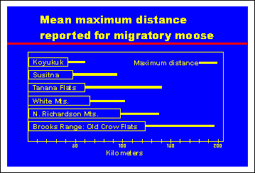 Up to 196 kilometers (120 miles) separate
summer and winter areas for some of the marked moose. This is the farthest that any moose are
known to migrate in Alaska. Up to 196 kilometers (120 miles) separate
summer and winter areas for some of the marked moose. This is the farthest that any moose are
known to migrate in Alaska.
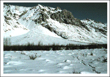 The moose remain in the valleys of the Brooks
Range throughout the winter. The moose remain in the valleys of the Brooks
Range throughout the winter.
- Question: If Old Crow Flats is such good moose habitat, why don't they stay in the
winter?
- Answer: Although the exact cause is not know, preliminary data suggest one
reason may be that snow is drifted into the willows on the Flats (average depths exceed 70 cm in
1997). In the Brooks Range valleys, the willows are protected from wind by the tall mountains,
and the snow in the willows is not so deep (average depth was 50 cm in 1997). In other studies,
snow depths greater than 70 cm have been found to significantly increase moose energy
requirements.
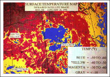 Another possible cause of this unusually long
seasonal migration may be the level of cold experienced on the Flats compared to that in the
mountains. As air cools, the molecules slow down their movement, and become more closely
packed together than they are in warmer air. This dense, cold air is therefore heavier, and sinks
down to the lowest areas. Because of this, the coldest air slides down off the mountains, and
pools in Old Crow Flats. Another possible cause of this unusually long
seasonal migration may be the level of cold experienced on the Flats compared to that in the
mountains. As air cools, the molecules slow down their movement, and become more closely
packed together than they are in warmer air. This dense, cold air is therefore heavier, and sinks
down to the lowest areas. Because of this, the coldest air slides down off the mountains, and
pools in Old Crow Flats.
 Moose in the highter mountain valleys of Alaska
may thus experience warmer winter temperatures, as well as having easier access to their winter
food (willows). These factors may help calves to survive the winter, and allow cows to give
birth to healthy young the following spring. Moose in the highter mountain valleys of Alaska
may thus experience warmer winter temperatures, as well as having easier access to their winter
food (willows). These factors may help calves to survive the winter, and allow cows to give
birth to healthy young the following spring.
 Summary: Because of the migratory
nature of many species in the Arctic Refuge, we have come to recognize the shared international
responsibility necessary to insure that our wild heritage is safeguarded for our use and enjoyment
now, and for those who will follow us in the future. Summary: Because of the migratory
nature of many species in the Arctic Refuge, we have come to recognize the shared international
responsibility necessary to insure that our wild heritage is safeguarded for our use and enjoyment
now, and for those who will follow us in the future.

Refuge Information | Wildlife | Habitat | People
Home | New | Feedback | Index | Search
Why we archived the ANWR website at Mapcruzin.com
Note: This is the MapCruzin.com archive of the FWS Arctic National Wildlife Refuge website. In December, 2001 FWS took this website offline, making it unavailable to the public. It includes 90 plus pages of information and many maps. As of 2006 the important information contained in this, the original "unsanitized" version of the FWS website, has yet to return to the internet, so we will continue to maintain it here as a permanent archive to help inform activists and concerned citizens. If you find any broken links, please report them to me at [email protected] and I will attempt to make the repairs. January, 2008 update - A small part of the original information that was present in 2001 has made it back into the current ANWR website. There is also an archive that contains a small amount of the original information, but it is not readily available from the main website.
Click here to visit our homepage. Click here for NRDC's message about ANWR from Robert Redford.
For more information on why this website was "pulled," Check here. And, you can also view the maps of caribou calving areas that the FWS did not want you to see here.
 January 29, 2008: Visit Our New ANWR News for Updates January 29, 2008: Visit Our New ANWR News for Updates
This page should be cited as follows:
U.S. Fish and Wildlife Service. 2001. Potential impacts of proposed oil and gas
development on the Arctic Refuge�s
coastal plain: Historical overview and
issues of concern. Web page of the Arctic National
Wildlife Refuge,
Fairbanks, Alaska.
17 January 2001. http://arctic.fws.gov/issues1.html
Archived by MapCruzin.com. Visit us at mapcruzin.com.
MapCruzin.com is an independent firm
specializing in the publication of
educational and research resources.
We created the first U.S. based
interactive toxic chemical facility
maps on the internet in 1996 and we
have been online ever since. Learn more about us and view some of our projects and services.
Contact Us
Report Broken Links
| 


