GIS Shapefile Store - for Beginners & Experienced GIS Users Alike. Geographic Names Information System, Nuclear Facilities, Zip Code Boundaries, School Districts, Indian & Federal Lands, Climate Change, Tornadoes, Dams - Create digital GIS maps in minutes.
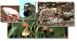
The Arctic National Wildlife Refuge is located in the northeast corner of Alaska. In this
region of extensive cold, much of the Refuge's soils are underlain with permafrost.
The Beaufort Sea washes against the north coast of the Refuge. These waters remain
ice-covered for eight or more months each year. The ice pack is the winter home for polar bear
and numerous seals. During the summer, whales migrate through these waters.
South of the coast lies a broad expanse of flat arctic tundra composed mostly of sedges and
low shrubs. Musk oxen live year-round on this coastal plain, and caribou produce their calves
here in late spring.
The arctic tundra rises to the south through foothills to the rugged, rocky mountains of the
Brooks Range. Dall sheep search for winter forage along windblown slopes, while marmots
hibernate within stony crevices for nine months each year.
Further south, mountains gradually merge into the spruce and shrubs of the boreal forest.
Beaver, mink, and moose, as well as numerous small rodents, inhabit the wet meadows, bogs,
and rivers within this forested region.
INSECTIVORES (shrews)
____ Masked (Common) Shrew(Sorex cinereus) Moist tundra, bogs, and forests.
____ Dusky Shrew(Sorex obscurus) Wet meadows south of the
mountains.
____ Arctic Shrew(Sorex arcticus) Wet sedge tundra.
____ Pygmy Shrew(Sorex hoyi) Forests and bogs south of the
mountains.
LAGOMORPHS (hares and rabbits)
____ Snowshoe Hare(Lepus americanus) Forests and shrub thickets.
RODENTS (squirrels, mice, porcupines, etc.)
____ Alaska Marmot(Marmota broweri) Rocky, mountainous areas.
____ Arctic Ground Squirrel(Spermophicus perryii) Dry, sandy areas.
____ Red Squirrel(Tamiasciurus hudsonicus) Spruce forests.
____ Muskrat(Ondatra zibethicus) Ponds and marshes south of the mountains.
____ Beaver(Castor canadensis) Wooded streams.
____ Meadow Vole(Microtus pennsylvanicus) Meadows and open forests
south of the mountains.
____ Tundra Vole(Microtus oeconomus) Meadows near water south of the
mountains.
____ Yellow-cheeked Vole(Microtus xanthognathus) Spruce forests near
bogs.
____ Singing Vole(Microtus miurus) Tundra and shrub thickets near
water.
____ Northern Red-backed Vole(Clethrionomys rutilus) Tundra and forests.
____ Brown Lemming(Lemus sibiricus) Wet tundra north of the
mountains.
____ Northern Bog Lemming(Synaptomys borealis) Bogs, spruce forests, and
meadows south of the mountains.
____ Collared Lemming(Dicrostonyx torquatus) Sedge tundra.
____ Meadow Jumping Mouse(Zapus hudsonius) Moist meadows and shrub
thickets south of the mountains.
____ Porcupine(Erethizon dorsatum) Forests, shrub thickets, and tundra.
CANIDS (foxes and wolves)
____ Coyote(Canis latrans) Rare in open areas.
____ Gray Wolf(Canis lupus) All plant communities throughout the
Refuge.
____ Arctic Fox(Alopex lagopus) Tundra north of the mountains.
____ Red Fox(Vulpes vulpes) All plant communities throughout the
Refuge.
FELIDS (cats)
____ Lynx(Felis lynx) Forests throughout the Refuge.
URSIDS (bears)
____ Black Bear(Ursus americanus) Forests throughout the Refuge.
____ Brown Bear(Ursus arctos) Open areas throughout the Refuge.
____ Polar Bear(Ursus maritimus) Along the coast and on ocean ice.
MUSTELIDS (weasels)
____ Marten(Martes americana) Spruce forests.
____ Ermine(Mustela erminea) Open forests and tundra.
____ Least Weasel(Mustela nivalis) Open, wet areas.
____ Mink(Mustela vison) Near wet areas south of the mountains.
____ Wolverine(Gulo gulo) Forests and tundra.
____ River Otter(Lutra canadensis) Rivers and lakes mainly south of the
mountains.
CERVIDS (deer)
____ Moose(Alces alces) Willow thickets and wet areas.
____ Caribou(Rangifer tarandus) All plant communities throughout the
Refuge.
BOVIDS (goats and sheep)
____ Muskox(Ovibos moschatus) Tundra north of the mountains.
____ Dall Sheep(Ovis dalli) Rocky slopes and tundra in the mountains.
PINNIPEDS (seals and walrus)
____ Walrus(Odebenus rosmarus) Rare along the coast.
____ Spotted Seal(Phoca largha) Coastal waters and on drifting ice.
____ Ringed Seal(Phoca hispida) Ice along the coast.
____ Bearded Seal(Erignathus barbatus) Coastal waters and on drifting
ice.
Note: This is the MapCruzin.com archive of the FWS Arctic National Wildlife Refuge website. In December, 2001 FWS took this website offline, making it unavailable to the public. It includes 90 plus pages of information and many maps. As of 2006 the important information contained in this, the original "unsanitized" version of the FWS website, has yet to return to the internet, so we will continue to maintain it here as a permanent archive to help inform activists and concerned citizens. If you find any broken links, please report them to me at [email protected] and I will attempt to make the repairs. January, 2008 update - A small part of the original information that was present in 2001 has made it back into the current ANWR website. There is also an archive that contains a small amount of the original information, but it is not readily available from the main website.
Click here to visit our homepage. Click here for NRDC's message about ANWR from Robert Redford.
U.S. Fish and Wildlife Service. 2001. Potential impacts of proposed oil and gas
development on the Arctic Refuge�s
coastal plain: Historical overview and
issues of concern. Web page of the Arctic National
Wildlife Refuge,
Fairbanks, Alaska.
17 January 2001. http://arctic.fws.gov/issues1.html
Archived by MapCruzin.com. Visit us at mapcruzin.com.
MapCruzin.com is an independent firm
specializing in the publication of
educational and research resources.
We created the first U.S. based
interactive toxic chemical facility
maps on the internet in 1996 and we
have been online ever since. Learn more about us and view some of our projects and services.


 January 29, 2008: