Refuge Information | Wildlife | Habitat | People
Home | New | Feedback | Index | Search
Why we archived the ANWR website at MapCruzin.com
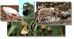
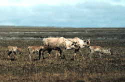
Caribou
Topics on this page:
Porcupine Caribou Herd
Caribou and the Coastal Plain
Porcupine Caribou Herd
Like antlered gypsies, barren ground caribou are always on the move. Exactly when and
where they go is impossible to predict. Most herds, however, are drawn to a specific calving
area.
The 129,000 member Porcupine caribou herd has such a connection with the Arctic National
Wildlife Refuge.
Named for the major river within its range, the Porcupine herd uses an area the size of
Wyoming in the Refuge, Yukon, and Northwest Territories. The herd winters in the southern
portion of its range, including the Refuge, where they are an important resource for the Gwichin
people.
Twice a year the herd migrates more than 700 miles to and from its traditional calving
grounds on the arctic coastal plain. Sometime in April, the caribou head north. The route they
take depends on snow and weather conditions.
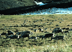
By early June, the pregnant females reach the calving areas and give birth. Shortly
thereafter, most, and often all, of the herd joins the cows and calves on the coastal plain of the
Refuge. In late June and early July, when hordes of mosquitos hatch, the caribou gather in huge
groups numbering in the tens of thousands. Seeking relief from the insects, they move along the
coast, onto ice fields, and to uplands in the Brooks Range.
 The herd
leaves the coastal plain by mid-July, heading back east and south toward its fall
and wintering areas. Just as no one knows in advance precisely where most of the caribou will drop
their calves in the spring, no one knows until it happens whether the majority of the herd will
winter on the south side of the Refuge or in Canada. The herd
leaves the coastal plain by mid-July, heading back east and south toward its fall
and wintering areas. Just as no one knows in advance precisely where most of the caribou will drop
their calves in the spring, no one knows until it happens whether the majority of the herd will
winter on the south side of the Refuge or in Canada.
Hunted by local residents, chased by predators, harassed by insects, challenged by river
crossings, and faced with difficult terrain and weather, the Porcupine herd confronts many
hardships. Yet it thrives, every summer staging a magnificent wildlife spectacle on the arctic
coastal plain. The caribou are a vital part of the natural system that operates there. Unalterably
linked to the area, the herd both depends on and enhances the dynamic wilderness that is the
Arctic Refuge.
Return to Top
Caribou and the Coastal Plain
The coastal plain comprises only 10 percent of the Arctic Refuge. Yet from May to July, it
is
the center of biological activity on the Refuge. For centuries, animals from the Porcupine
caribou herd have used the coastal tundra to calve, obtain nourishment, avoid insects, and escape
predators.
The calving grounds of the Porcupine caribou herd include the northern foothills of the
Brooks Range and the arctic coastal plain from the Tamayariak River in Alaska to the Babbage
River in Canada. The most often used calving area, however, is on the Refuge coastal plain
between the Katakturuk and Kongakut Rivers. Commonly, one-half to three quarters or more of
the calves are born within this area.
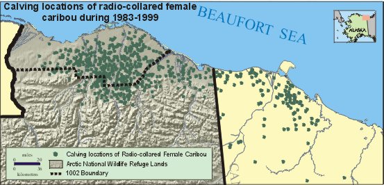
 The Refuge coastal plain is very important to calving success and calf survival in the
Porcupine caribou herd. There are two main reasons for this. First, fewer brown bears, wolves,
and golden eagles live on the coastal plain than in the adjacent foothills and mountains. As a
result, the newborn calves have a better chance to survive their first week, until they become
strong enough to outrun their pursuers. The Refuge coastal plain is very important to calving success and calf survival in the
Porcupine caribou herd. There are two main reasons for this. First, fewer brown bears, wolves,
and golden eagles live on the coastal plain than in the adjacent foothills and mountains. As a
result, the newborn calves have a better chance to survive their first week, until they become
strong enough to outrun their pursuers.
The Refuge coastal plain also provides an abundance of plant species preferred by caribou.
Nutrition is very important to the pregnant cows, particularly after the long winter. The timing
of snow melt and plant "green up" on the coastal plain coincides with their calving period. This
gives the new mothers access to the most nutritious food when it is most important for their
health and the proper development of nursing calves.
The entire Porcupine caribou herd and up to a third of the Central Arctic herd use the
Refuge
coastal plain when calving is completed. This essential area contains forage and a variety of
habitats that provide insect relief, including the coast, uplands, ice fields, rocky slopes, and
gravel bars.
Their annual visit to the Refuge coastal plain brings new life and vitality to the caribou. It is
an important part of their life cycle. The coastal plain provides the caribou vital nourishment
and
a better chance of avoiding predators and insects. This relationship is part of the unaltered
system that makes the Arctic Refuge such a wondrous place.
Return to Top

Refuge Information | Wildlife | Habitat | People
Home | New | Feedback | Index | Search
Why we archived the ANWR website at Mapcruzin.com
Note: This is the MapCruzin.com archive of the FWS Arctic National Wildlife Refuge website. In December, 2001 FWS took this website offline, making it unavailable to the public. It includes 90 plus pages of information and many maps. As of 2006 the important information contained in this, the original "unsanitized" version of the FWS website, has yet to return to the internet, so we will continue to maintain it here as a permanent archive to help inform activists and concerned citizens. If you find any broken links, please report them to me at [email protected] and I will attempt to make the repairs. January, 2008 update - A small part of the original information that was present in 2001 has made it back into the current ANWR website. There is also an archive that contains a small amount of the original information, but it is not readily available from the main website.
Click here to visit our homepage. Click here for NRDC's message about ANWR from Robert Redford.
For more information on why this website was "pulled," Check here. And, you can also view the maps of caribou calving areas that the FWS did not want you to see here.
 January 29, 2008: Visit Our New ANWR News for Updates January 29, 2008: Visit Our New ANWR News for Updates
This page should be cited as follows:
U.S. Fish and Wildlife Service. 2001. Potential impacts of proposed oil and gas
development on the Arctic Refuge�s
coastal plain: Historical overview and
issues of concern. Web page of the Arctic National
Wildlife Refuge,
Fairbanks, Alaska.
17 January 2001. http://arctic.fws.gov/issues1.html
Archived by MapCruzin.com. Visit us at mapcruzin.com.
MapCruzin.com is an independent firm
specializing in the publication of
educational and research resources.
We created the first U.S. based
interactive toxic chemical facility
maps on the internet in 1996 and we
have been online ever since. Learn more about us and view some of our projects and services.
Contact Us
Report Broken Links
| 


