GIS Shapefile Store - for Beginners & Experienced GIS Users Alike. Geographic Names Information System, Nuclear Facilities, Zip Code Boundaries, School Districts, Indian & Federal Lands, Climate Change, Tornadoes, Dams - Create digital GIS maps in minutes.
[This information was originally produced by Beverly Skinner, wildlife biologist at Innoko
National Wildlife Refuge (in west central Alaska), for radio broadcast on Public Radio stations
throughout Alaska.]
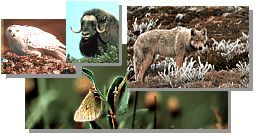
Breeding Bird Surveys and Partners in Flight
This month, all across Alaska, neo-tropical breeding birds are being identified and counted
by biologists and volunteers along established bird routes. The Innoko Refuge staff now has
seven separate routes to complete during the prime breeding and singing period of June 10
through the 30th. The refuge is currently involved with both the national breeding bird
survey program as well as the newer Alaska Partners in Flight off road breeding bird point
count survey program. Although the two programs have slightly different methods of counting
birds, the end result is the same - a yearly tally of all birds seen or heard along a
permanent route which allows for a comparison over time of the numbers of each bird species.
This is know as trend data.
Neo-tropical birds return to Alaska to nest each summer in the brightest plumage and full
of song. Their brightly colored feathers and singing allow the male birds to non-violently
compete against other male birds for a territory. In mid through late June, by moving through
an area constantly singing, the males are able to stake out a territory for themselves
and their mate which will provide the needed space and food to raise a nest full of young.
It is during this time of constant singing that bird survey routes are conducted. Routes
are started at dawn, which for interior Alaska is 3:33 am, and continue throughout the peak
singing time each day.
To run a successful bird route, the observer needs to be able to identify by sight, song
and call all bird species likely to be encountered. For me, this means several weeks prior
to the birding season each spring listening to bird tapes and spending many early mornings
out practicing. It is always a relief each spring when I hear all the old songs of familiar
birds but also very exciting when I hear something new.
The two national breeding bird routes on the Innoko refuge are both river routes and are
run by boat. A third route run by four wheeler lies along the Sterling landing to Takotna
road down river from McGrath in cooperation with the Air Force and the Tatalina Radar site.
Our newest route here in McGrath was run for the second time this year. This particular route
is under the direction of McGrath resident Kevin Whitworth who is an excellent birder and also
the refuge Resource Apprenticeship Program for Students (RAPS) student for a third year in a row.
The refuge also has three walking routes
placed in different types of habitat: a bog, a black spruce upland, and a white spruce lowland.
For Alaska Naturally and the Innoko National Wildlife Refuge,
this is Beverly Skinner. This year the refuge staff
has expanded the June bird work. We've added an additional 50 transects which cross through the
Innoko River riparian (river corridor) areas. As the transects are walked, exact bird
locations are recorded with a global positioning system (GPS). These locations will
eventually become another data layer within our geographical information system (GIS)
computer system. As our records for each bird species
increase over the next few years, we hope to be able to produce reliable habitat maps for
all the different birds who call the Innoko refuge home for the summer.
Note: This is the MapCruzin.com archive of the FWS Arctic National Wildlife Refuge website. In December, 2001 FWS took this website offline, making it unavailable to the public. It includes 90 plus pages of information and many maps. As of 2006 the important information contained in this, the original "unsanitized" version of the FWS website, has yet to return to the internet, so we will continue to maintain it here as a permanent archive to help inform activists and concerned citizens. If you find any broken links, please report them to me at [email protected] and I will attempt to make the repairs. January, 2008 update - A small part of the original information that was present in 2001 has made it back into the current ANWR website. There is also an archive that contains a small amount of the original information, but it is not readily available from the main website.
Click here to visit our homepage. Click here for NRDC's message about ANWR from Robert Redford.
U.S. Fish and Wildlife Service. 2001. Potential impacts of proposed oil and gas
development on the Arctic Refuge�s
coastal plain: Historical overview and
issues of concern. Web page of the Arctic National
Wildlife Refuge,
Fairbanks, Alaska.
17 January 2001. http://arctic.fws.gov/issues1.html
Archived by MapCruzin.com. Visit us at mapcruzin.com.
MapCruzin.com is an independent firm
specializing in the publication of
educational and research resources.
We created the first U.S. based
interactive toxic chemical facility
maps on the internet in 1996 and we
have been online ever since. Learn more about us and view some of our projects and services.


 January 29, 2008: