GIS Mapping, Education and Research
Home   Store   Free GIS   Education   Free Shapefiles   Census   Weather   Energy   Climate Change   News   Maps   TOPO   Aerial   GPS   Learn GIS

DOWNLOAD SHAPEFILES: Canada FSA Postal - Zip Code - U.S. Waterbodies & Wetlands - Geographic Names - School Districts - Indian Federal Lands
Zip Code/Demographics - Climate Change - U.S. Streams, Rivers & Waterways - Tornadoes - Nuclear Facilities - Dams & Risk - 2013 Toxic Release Inventory TRI

<-- Return to Do It Yourself GIS Maps

Indian & Federal Lands
ArcGIS Shapefiles

Click here if you are new to GIS and you
want to know what it is and how it is used.

Coverage: All U.S. including Hawaii and Alaska.

TatukGIS Viewer 19.3 mb
TatukGIS Viewer documentation 2.2 mb
ArcExplorer 2.2 13.5 mb
ArcExplorer Java 63.6 mb

These ArcGIS shapefiles work with the free ArcExplorer GIS viewer, ArcView GIS, ArcGIS, Maptitude, Mapinfo, Manifold, TatukGIS and many other commercial GIS and mapping programs and many free GIS programs as well. Each layer includes easy to follow instructions that show you how to add streets, highways, census information and much more to your maps for free. We have included national level base maps with each map archive listed below. Also, check our free GIS software and free GIS ArcGIS shapefiles pages for more information and free ArcGIS shapefiles.

No Experience Required

The shapefiles come with easy to follow instructions for downloading ArcExplorer, a free GIS map viewer. We provide step-by-step instructions so that you can easily learn to use and view the maps. For more help, take advantage of our free Learn2Map GIS Tutorial & Atlas.

Immediate Download

Each shapefile map layer is $97 or you can purchase them all for $497 saving a considerable amount. Click next to the map you wish and you will have immediate access to it using our secure merchant account provider, ClickBank.

Important! Please note that your credit card or bank statement will show a payment to ClickBank or CLKBANK*COM.

Indian Lands (BIA) - Bureau of Land Management (BLM) - Bureau of Reclamation (BOR)
Department of Defense (DOD) - Forest Service (USFS)
Fish and Wildlife Service (FWS) - National Park Service (NPS)

Bureau of Indian Affairs (BIA) (details)
Download: click here.

Bureau of Land Management (BLM) (details)
Download: click here.

Bureau of Reclamation (BOR) (details)
Download: click here.

Department of Defense (DOD) (details)
Download: click here.

Forest Service (FS) (details)
Download: click here.

Fish & Wildlife Service (FWS) (details)
Download: click here.

National Park Service (NPS) (details)
Download: click here.


Download Them All

Purchase all Indian and Federal Lands shapefiles listed for $497. Download Now.


Additional Map Layers Included Free With Purchase of Any Shapefile

The free national base map shapefiles include:

  • Cities
  • Roads
  • Rivers
  • States
  • Water Bodies

The free "Other Federal Facilities" shapefile includes these themes:

  • Agricultural Research Service ARS
  • Bureau of Prisons DOJ
  • Central Intelligence Agency CIA
  • Department of Energy DOE
  • Department of Transportation DOT
  • General Services Administration GSA
  • Metropolitan Washington Airports Authority
  • National Aeronautics and Space Administration NASA
  • Tennessee Valley Authority TVA
  • U.S. Coast Guard DOT
  • United States Department of Agriculture USDA

Theme Descriptions:

Bureau of Indian Affairs (BIA) - 542 polygons - Download Now

  • Indian Reservations

Download Indian Lands (BIA) Shapefile.

Back to top


Burea of Land Management (BLM) - 21,044 polygons - Download Now
  • Forest Reserves
  • National Conservation Areas
  • National Monuments
  • National Recreation areas
  • Public Domain Lands
  • Wilderness
  • Wilderness Study Areas
  • Other BLM

Download Bureau of Land Management (BLM) Shapefile.

Back to top


Bureau of Reclamation (BOR) - 545 polygons - Download Now
  • Bureau of Reclamation

Download Bureau of Reclamation (BOR) Shapefile.

Back to top


Department of Defense (DOD) - 897 polygons - Download Now
  • Air force
  • Army
  • Army Corps of Engineers
  • Department of Defense
  • Marine Corps
  • Navy

Download Department of Defense (DOD) Shapefile.

Back to top


Forest Service (FS) - 2,384 polygons - Download Now
  • National Forests
  • National Grasslands
  • National Monuments
  • National Recreation Areas
  • National Scenic Areas
  • Purchase Unit Blocks
  • Wilderness
  • Wilderness Study Areas

Download U.S. Forest Service (USFS) Shapefile.

Back to top


Fish & Wildlife Service (FWS) - 1,726 polygons - Download Now
  • National Fish Hatchery
  • National Wildlife Refuge
  • Waterfowl Production Area
  • Wilderness
  • Wilderness Study Area
  • Wildlife Management Area

Download Fish and Wildlife Service (FWS) Shapefile.

Back to top


National Park Service (NPS) - 897 polygons - Download Now
  • National Battlefields
  • National Battlefield Park
  • National Capital Parks
  • National Historic Parks
  • National Historic Sites
  • National Lakeshores
  • National Mall
  • National Memorials
  • National Military Parks
  • National Monuments
  • National Parks
  • National Parkways
  • National Preserves
  • National Recreation Areas
  • National Reserves
  • National Rivers
  • National Seashores
  • National Wild and Scenic Rivers
  • Wilderness
  • Wilderness Study Areas

Download National Park Service (NPS) Shapefile.

Back to top


Download Them All

Purchase all Indian and Federal Lands shapefiles listed for $497. Download Now.


Map Creation

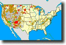
Each map layer was created by extracting federal land polygon features from the individual 1:2,000,000-scale State boundary Digital Line Graph (DLG) files produced by the U.S. Geological Survey. These files were then appended into a single coverage. Individual layers (above) were extracted from this coverage. (Source: USGS).

Important! Please note that your credit card or bank statement will show a payment to ClickBank or CLKBANK*COM.

A Note About How Your GIS Maps Will Look

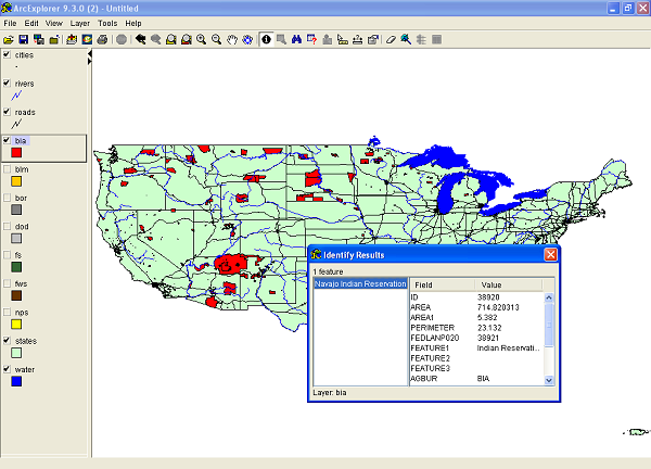
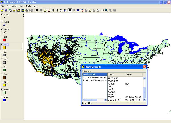
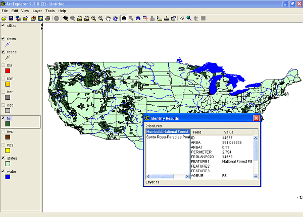
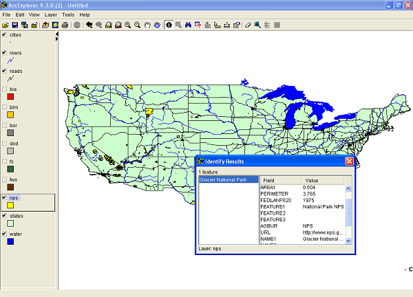
The image(s) on this page are examples of how these shapefiles may look when loaded into a GIS program. Your GIS maps may not look exactly like this. Each GIS program is different. Shapefiles themselves are a collection of points, lines or polygons. They have no attributes. It is up to you, the user, to define colors, line width, symbols and other attributes within the limits and capabilities of the GIS programs you are using.

Copyright and Use of Shapefiles

The shapefiles on this page are copyrighted as follows. Copyright © 2017 Michael R. Meuser, All Rights Reserved. You may use these shapefiles in any GIS project or to make maps. You may not create copies of the shapefiles for the use of others whether for personal or commercial use. You may not resell the shapefiles. If you require multiple copies of the same shapefile, please contact Mike at [email protected]. Thank You.

About Quality, Accuracy and Suitability

This data may come from a variety of U.S. government, non-governmental and self-reporting private sources. While we try to assure the accuracy of this material, we cannot promise that it is absolutely accurate. We do promise that using the map layer will be fun, entertaining or educational. Beyond this, we make no guarantee as to its suitability for any purpose. We assume no liability or responsibility for errors or inaccuracies. Please understand that you use these map layers and data at your own risk.

Thank You,

<-- Return to Do It Yourself GIS Maps

Didn't find what you are looking for? We've been online since 1996 and have created 1000's of pages. Search below and you may find just what you are looking for.


Michael R. Meuser
Data Research & GIS Specialist

MapCruzin.com is an independent firm specializing in GIS project development and data research. We created the first U.S. based interactive toxic chemical facility maps on the internet in 1996 and we have been online ever since. Learn more about us and our services.

Have a project in mind? If you have data, GIS project or custom shapefile needs contact Mike.

Contact Us

Report Broken Links

Subscribe for Updates

About MapCruzin - Cookies, Privacy, Fair Use and Disclaimer - Advertise on MapCruzin.com

Copyright © 1996 - 2019 Michael Meuser, All Rights Reserved
MapCruzin is a Pop-Up Free Website -- Best Viewed With ANY Browser