Tools & resources for re-imagining our relationships with each other and the earth
Home   Free GIS   Download Shapefiles   Energy Maps Shapefiles   Free Maps   TOPO   Remote Sensing   GPS   Learn GIS

Energy Maps Shapefiles   Indian & Federal Land Shapefiles   Oil Gas Reserves Maps   GIS Degrees & Certificates

Subscribe for updates,
feeds, and newsletter
Enter your email address:

Delivered by FeedBurner

D.I.Y. Do It Yourself GIS Maps - for Beginners & Experienced GIS Users Alike. Indian & Federal Lands, Climate Change - Create digital GIS maps in minutes ... more

Maps.com: The Place for Maps Online

Online GIS Certicates, Degrees, Diplomas - Distance Learning

ALL, American Sentinel University, Birkbeck, City University London, Curtin University GIS Certificate, Curtin University Graduate Diploma, Curtin University M.S., DePaul University, Eastern Michigan University, Elmhurst College, Emporia State University, GIS Certification Institute, John Hopkins University, Northwest Missouri State, Penn State, Purdue, Roosevelt University, UNIGIS Network, University of Colorado, University of Denver, University of Leeds, University of Montana, University of North Dakota, University of Southern California, URISA, Vancouver Island University, ALL

Mapcruzin Free GIS Tools, Resources, News and Maps

Follow Mapcruzin.com on Twitter
Follow on Twitter

A Member of the
Reimagination Network

Didn't find what you are looking for? Email me and I'll find it for you.

Have a question or comment? Post them at the MapCruzin Blog.

Climate Shift Blog

MapCruzin Consulting
GIS and Google Maps Development, Website Creation and Hosting, Fast and Affordable.

Partners
Climate Shift, Recycle, Reuse & Salvage, TerraKnowledge.net, Climate Injustice, Pollution Map Projects, News & Resources, Blue Creek - Ah Pah, Right Livelihoods, Reimagination, Redwood Ecotours

Recycling Secrets Blog

GIS Tutorials

GIS Basics

GIS Terminology

Of Interest

Home Based Recycling Business - Free resources and tools.

Reimagination - Reimagining, exploring and celebrating the changes in infrastructure, politics and culture that will help us live in harmony with each other and the earth now and in the future.

Arctic National Wildlife Refuge

Climate Shift - The effects of climate shift on the future of planet earth and its inhabitants.

Right to Know or Left to Wonder?

Tools for Survival

Hazardscapes - Toxic and Nuclear Risks in your backyard.

War & Environment

Worst Case Scenarios: Terrorism & industrial chemicals.

Redwood Ecotours: Explore California's Redwood North Coast.


poets against the war

Viewable with ANY browser


Download Free Montana National Park and Historic Monument Maps

<-- Download Free Maps
<-- Free National Park Maps

Our growing collection of free-to-use national park, monument, historic site, recreation area, battlefield, park trails and visitor information maps from the National Park Service. They are in high resolution PDF or image formats ready for you to view, print and use. Please check back as we add new ones as they become available.

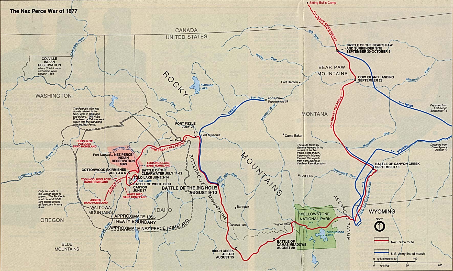
Big Hole National Battlefield - The Nez Perce War of 1877 (Area Map) 1994 (402K)

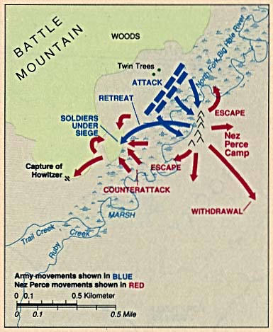
Big Hole National Battlefield (Battle Map) 1994 (41K)

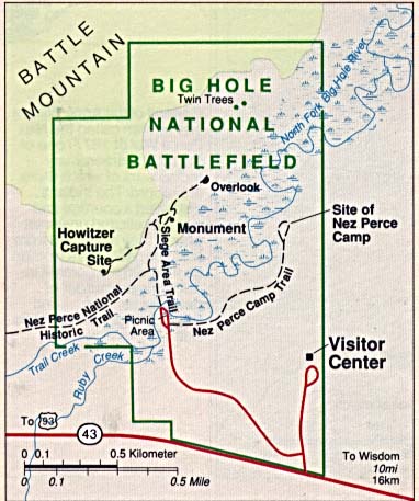
Big Hole National Battlefield (Park Map) 1994 (47K)

Bighorn Canyon National Recreation Area [Montana / Wyoming] (Area Map) 1997 (65K) (PDF Format)

Bighorn Canyon National Recreation Area [Montana / Wyoming] (Park Map) 1997 (258K) (PDF Format)

Glacier / Waterton International Peace Park [Alberta, Canada / Montana, U.S.] (Area Map) (34K)

Glacier / Waterton International Peace Park [Alberta, Canada / Montana, U.S.] (Park Map) (857K)

Glacier / Waterton International Peace Park [Alberta, Canada / Montana, U.S.] (Park Map) 1997 (645K) (PDF Format)

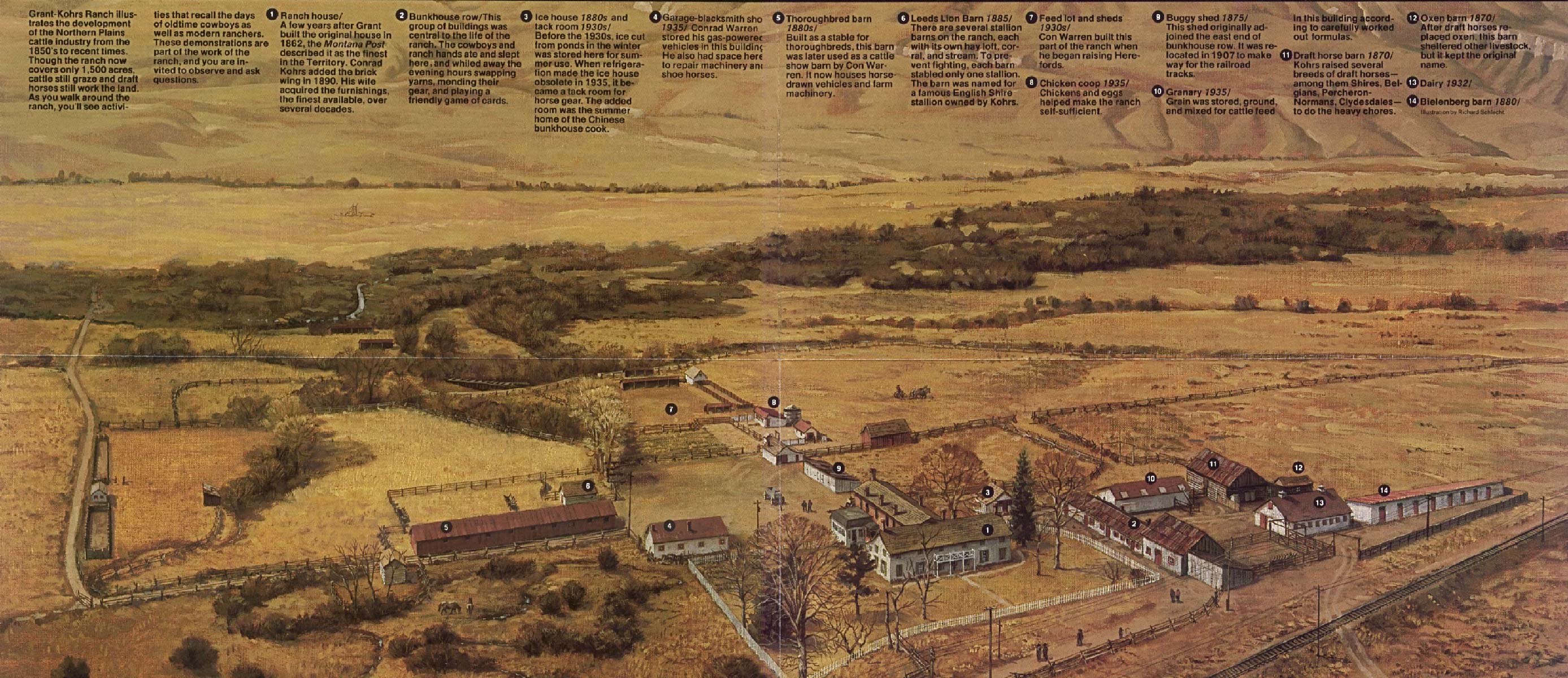
Grant-Kohrs Ranch National Historic Site (Schematic Map) (661K)

Little Bighorn Battlefield National Monument (Battle of 1876) 1999 (65K) (PDF Format)

Little Bighorn Battlefield National Monument (Park Map) 1999 (194K) (PDF Format)

Nez Perce National Historical Park [Idaho/montana/oregon/washington] (All Sites Map) 1997 (65K) (PDF Format)

Waterton-Glacier International Peace Park [Alberta, Canada / Montana, U.S.] (Park Map)(857K)

Waterton-Glacier International Peace Park - Ville Townsite [Alberta, Canada / Montana, U.S.] (Detail Map) (34K)

Yellowstone National Park [Montana / Wyoming / Idaho] (Park Map) (1MB)

Yellowstone National Park [Montana / Wyoming/ Idaho] (Park and Detail Maps) 1998 (1MB) (PDF Format)

Yellowstone National Park - Canyon Village [Montana / Wyoming / Idaho] (Detail Map) (39K)

Yellowstone National Park - Fishing Bridge, Lake Village and Bridge Bay [Montana / Wyoming / Idaho] (Detail Map) (43K)

Yellowstone National Park - Madison Plateau [Montana / Wyoming / Idaho] (Shaded Relief Map) 1:125,000, U.S. Geological Survey 1974 (425K)

Yellowstone National Park - Mammoth Hot Spring [Montana / Wyoming / Idaho] (Detail Map) (45K)

Yellowstone National Park - Old Faithful [Montana / Wyoming / Idaho] (Detail Map) (39K)

Yellowstone National Park - West Thumb and Grant Village [Montana / Wyoming / Idaho] (Detail Map) (31K)

<-- Download Free Maps
<-- Free National Park Maps


MapCruzin.com is an independent firm specializing in the publication of educational and research resources. We created the first U.S. based interactive toxic chemical facility maps on the internet in 1996 and we have been online ever since. Learn more about us and view some of our projects and services.

Contact Us

Report Broken Links

Didn't find what you are looking for? We've been online since 1996 and have created 1000's of pages. Search below and you may find just what you are looking for.

Bookmark and Share

Free GIS Resources

Free GIS Software, ArcGIS shapefiles, GIS Degree Certificate Online, World ArcGIS Shapefiles, Learn2Map GIS Tutorial and Atlas, State GIS Shapefiles, U.S. Boundary Shapefiles, Open GIS Shapefiles, GIS Jobs & Training, U.S. State GIS Resources Census Tiger Line Shapefiles, National Transportation Shapefiles, Free Wireless ArcGIS Shapefiles, Mexico, Canada, U.S. Shapefiles, TOPO and Terrain Maps, GPS Resources and Tutorials, Free GIS & Geospatial Programs, Google Earth and Google Maps mashups, resources, maps and tools, EPA Geospatial Shapefiles, GeoData, National Geodetic Survey Software, MrSid, JPEG2000 and GeoTIFF Maps, Satellite Aerial Photos, TRI National Analysis Data, Shapefiles, Toxic Maps with Google

Most Popular

GIS Degree Certificate Online, Free GIS & Geospatial Software, Indian & Federal Lands Shapefiles, Free GIS Shapefiles, Geospatial Data & Geodata, myRTK Toxic Maps for Mobile Devices, Oil and Gas Field Maps Shapefiles, World Oil & Gas Reserves, Production, Exploration, Renewable Energy Shapefiles, Remote Sensing, Satellite & Aerial Photos, Residential Energy Consumption Maps, Open GIS Shapefiles, World ArcGIS Shapefiles, Free Maps, Transportation Shapefiles, Toxics, Chemicals, Schools, Renewable Energy Shapefiles, Renewable Energy Potential Maps, 2009 Tiger Line Shapefiles, World Energy Maps, FCC Wireless Licensing Market Boundary Shapefiles, TRI National Analysis Data, Shapefiles, U.S. State ArcGIS Shapefiles, Afghanistan ArcGIS Shapefiles, Natural Disaster ArcGIS Shapefiles, U.S. State Maps, Health Uninsured Maps, Climate Change, Afghanistan Maps, Cell Phone Health, Towers, Maps, Google Earth & Maps, Arctic National Wildlife Refuge Maps, Economy Maps, TOPO Maps

MapCruzin Blog for updates, questions and answers

Blog Updates

More Blog Updates

Downloads

Google Earth Toxic Release Inventory (TRI) Maps
Lester Brown's Plan B 3.0
State GIS Shapefiles, Maps & Resources
GIS Shapefiles & Maps
GIS Programs, Tools & Resources
Free World Country & Regional Maps
GIS / GPS Careers and Job Positions
Disease Outbreak Maps
TOPO Maps
Extreme Weather & Disaster Maps
Free World Maps from the CIA Factbook
Arctic National Wildlife Refuge ANWR Maps
Oil and Gas Maps
Africanized Honey Bees
Renewable Energy Potential Maps of the United States
Terrorism Maps
War Maps
Google Maps
Weather Maps
GPS Resources
Historical Maps of the World
Google Earth
Library of Congress American Memory Map Downloads
Toxic Chemical Pollution Maps
Climate Change Maps
Toxic Release Inventory (TRI) Maps
Census Shapefiles
World Maps

Issues

Environmental Justice
Data Sources
Greenwash & JunkScience
Statistical Resources
Wireless Dangers
Surviving Climate Change
Global Right-To-Know
Creating Living Economies
Books of Note
Toxic Klamath River
Federal Lands Maps
TRI Analysis
TRI Webmaps
EnviroRisk Map Network
Community-Based Research
Right-To-Know or Left to Wonder?
Chemical Industry Archives
21st Century Warfare
Biotechnology
Nanotechnology
Globalization/Democracy
National Parks and Public Lands
Trade Secrets/Toxic Deception
GIS Books
Our Projects
Other Projects
1999 Archive Environews
Environmental Books
Environmental Links
Redwood Coast Information
Recycle, Salvage, Reuse

Resources

Environmental Book Discounts
Korten - Speth - Bullard
Environmental Justice
Hawken - Climate Change
Peak Oil - Alternative
Energy - Nuclear Risk
Water Crisis - Food Crisis
Energy Crisis - Housing
Crisis

GIS Book Discounts
GIS - GPS - Remote
Sensing - Google Maps
Cartography - Geography
Maps - Google Earth

About MapCruzin - Privacy, Fair Use and Disclaimer - Advertise on MapCruzin.com

Home | Free GIS | Downloads | Parks & Public Lands | Books | Environmental Justice | News Archives
Free GIS Tutorial | Consulting | TRI 2004 MAPS | Recycle Reuse Business | Toxics Explorer
North Coast GIS | Contact/About Us | Redwood Ecotours | Global Positioning | EnviroRisk Map Network
Climate Collapse | Free GIS Tutorial | What is GIS? | Right to Know | Reimagination | Health & GIS | Shrubbed | Search

[an error occurred while processing this directive]

Questions, Comments or Suggestions? Contact Us

Website development and hosting provided by the Reimagination Network

Copyright © 1996 - 2010 Reimagination Network, All Rights Reserved
MapCruzin is a Pop-Up Free Website -- Best Viewed With ANY Browser