Download Free United States of America Historical Maps
Sponsors
<-- Return to Main Free Maps Download Page
<-- Return to Free Historical Maps Page
Go To Maps beginning with:
A -
B -
C -
D -
E -
F -
G -
H -
I -
J -
K -
L -
M -
N -
O -
P -
Q -
R -
S -
T -
U -
V -
W -
X -
Y -
Z
Caddoan Languages and Peoples 17th and 18th Centuries (Texas Beyond History)
California as an island, Louis Hennepin 1699 (University of Minnesota)
California - Beckwourth Trail (Beckwourth.org)
California 1873 - Bancroft's Map of California, Nevada, Utah and Arizona (UNLV Libraries)
California 1895 (Color Landform Atlas/Ray Sterner)
California 1901 Southern Pacific Railway Map (David Rumsey Collection)
California - Historical Road Maps of Southern California (Mike Ballard)
California - Historic Topographic Maps (California State University, Chico)
California - Historic Topographic Maps - Los Angeles (William Bowen)
California - Historic Topographic Maps - San Francisco Bay Area (UC Berkeley Library)
Cattle Drive Map - Colorado, Kansas, New Mexico (Old Colorado City)
Census Atlases: Presenting the Nation's Cultural Geography (Library of Congress Geography and Map Division/American Memory)
Charlestown, South Carolina Siege 1776 (earlyamerica.com)
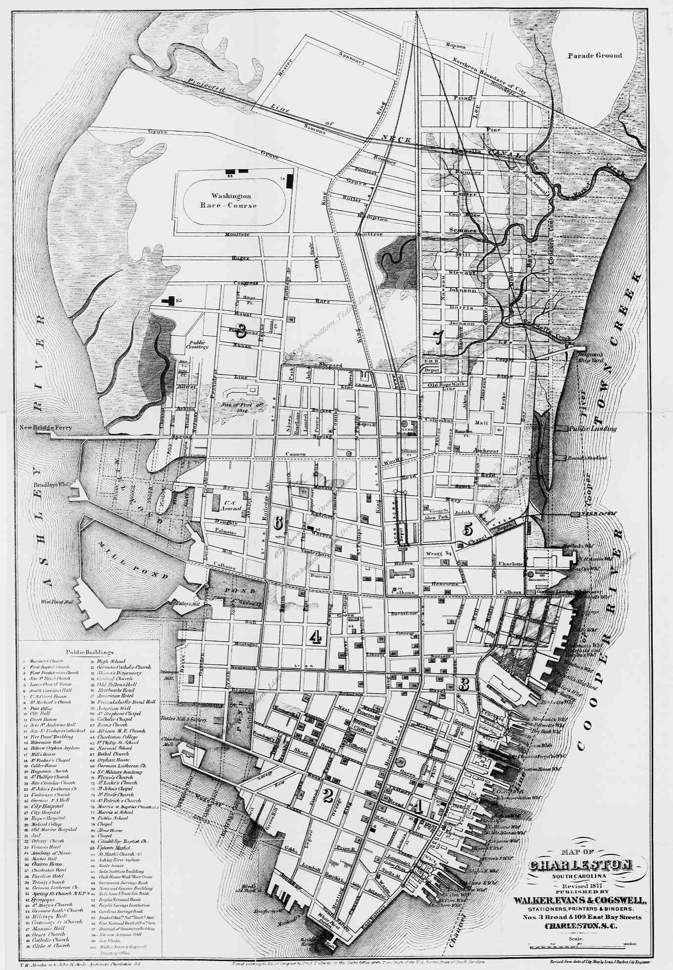
Charleston, South Carolina 1877 (University of Georgia)
Charlottesville, Virginia - Sanborn Fire Insurance Maps (University of Virginia Libraries)
Cherokee Historical Maps (Ken Martin)
Chicago 1857 Rufus Blanchard [pre-fire map] (David Rumsey Collection) [Opens in new window]
Chicago 1871 Great Fire
Chicago 1886 Robinson's Atlas, Fire insurance maps (University of Illinois at Chicago)
Chicago 1931 A Map of Chicago's Gangland from Authentic Sources (University of Illinois)
Chisholm Trail (Along the Chisholm Trail)
Civil War Atlas (U.S. Military Academy, History Department)
Civil War Maps (Library of Congress Geography and Map Division/American Memory)
Civil War - State Maps Showing Battle Sites
Cleveland Historical Maps from (Cleveland Cartography/William C. Barrow)
Colorado 1872 (Pam Rietsch)
Colorado 1895 (Color Landform Atlas/Ray Sterner)
Colorado and Wyoming - Overland Trail 1862-1869 (Elizabeth Larson)
Columbus Letter Exhibit (Univ. of Southern Maine)
Connecticut Historical Maps (University of Connecticut Libraries)
Connecticut - Historic Topographic Maps (Maptech)
Connecticut - Historic Topographic Maps (University of New Hampshire)
Connecticut 1895 (Color Landform Atlas/Ray Sterner)
Counties, U.S. - Historical County Lines (John Robertson)
<-- Return to Main Free Maps Download Page
<-- Return to Free Historical Maps Page
About Quality, Accuracy and Suitability
 These GIS software tools, programs and resources come from a variety of U.S.
government and private
sources. While we try to assure the accuracy of
this material, we cannot promise that it is
absolutely accurate. We do promise that using what you find here will be fun, entertaining or educational - perhaps even frustrating.
Beyond this, we make no guarantee as to its
suitability for any purpose. We assume no liability
or responsibility for errors or inaccuracies. Please
understand that you use these tools, programs and resources at your own
risk.
These GIS software tools, programs and resources come from a variety of U.S.
government and private
sources. While we try to assure the accuracy of
this material, we cannot promise that it is
absolutely accurate. We do promise that using what you find here will be fun, entertaining or educational - perhaps even frustrating.
Beyond this, we make no guarantee as to its
suitability for any purpose. We assume no liability
or responsibility for errors or inaccuracies. Please
understand that you use these tools, programs and resources at your own
risk.
Thanks,
Didn't find what you are looking for? We've been online since 1996 and have created 1000's of pages. Search below and you may find just what you are looking for.
Michael R. Meuser
Data Research & GIS Specialist
MapCruzin.com is an independent firm
specializing in GIS project development and data research.
We created the first U.S. based
interactive toxic chemical facility
maps on the internet in 1996 and we
have been online ever since. Learn more about us and our services.
Have a project in mind? If you have data, GIS project or custom shapefile needs contact Mike.
Contact Us
Report Broken Links
Subscribe for Updates
Sponsors


