GIS Shapefile Store - for Beginners & Experienced GIS Users Alike. Geographic Names Information System, Nuclear Facilities, Zip Code Boundaries, School Districts, Indian & Federal Lands, Climate Change, Tornadoes, Dams - Create digital GIS maps in minutes.
During the early 1900's moose were rare on the Alaskan north slope (that protion of Alaska that
is north of the Brooks Range mountains). Moose gradually increased and
peaked in the late 1980's. In 1985 biologists of the Arctic Refuge began to monitor north slope
moose by conducting aerial counts during late fall when there is good snow cover to help spot moose.
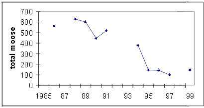
The graph above represents total moose counted in the area of the north slope between the Dalton Highway
and the Canning River. Moose numbers in this area declined from high levels (about 600) in 1989 to a low of 97
counted in 1997. A similar reduction of moose was documented by the Alaska Department of
Fish and Game in the region west of the Dalton Highway, including the Colville River area. In 1995
the State of Alaska Board of Game and the Federal Subsistence Board issued regulations closing
nearly all of the Alaskan north slope to moose hunting (a small harvest of moose was
authorized for subsistence in the vicinity of Nuiqsut).
Several possible explanations have been developed to try to account for the north slope
moose decline. During winter, moose are confined to relatively limited areas of riparian
willows along the northern margin of the Brooks Range where snow is usually not drifted by wind.
There is some evidence that concentrations of moose in these areas reached or possibly exceeded the
maximum level that the habitat could support. Thus moose may have declined as a result of habitat overuse.
Another consideration is that wolves and bears have become more abundant on the north slope as a
result of bear harvest restrictions established in the early 1970's and reduced aerial hunting of
wolves. In addition, during the 1980's, human harvest in some areas increased as the region became
more accessible due to completion of the Dalton Highway. It is likely that all of these factors
(habitat overuse, predation and human harvest) in combination functioned to reduce moose populations
on the Alaskan north slope.
Over the past half century, the increasing presence of moose on the Alaskan north slope added
diversity to the large mammal community and provided additional opportunity as a source of red meat
for hunters, especially in times when caribou are not available. Because moose are at the
northernmost edge of their distribution on the north slope, they may be more vulnerable to periodic
oscillations in abundance, requiring harvest closures during periods of low numbers.
Since north slope moose populations have remained at low levels, it is imperative to continue
monitoring their status.
Note: This is the MapCruzin.com archive of the FWS Arctic National Wildlife Refuge website. In December, 2001 FWS took this website offline, making it unavailable to the public. It includes 90 plus pages of information and many maps. As of 2006 the important information contained in this, the original "unsanitized" version of the FWS website, has yet to return to the internet, so we will continue to maintain it here as a permanent archive to help inform activists and concerned citizens. If you find any broken links, please report them to me at [email protected] and I will attempt to make the repairs. January, 2008 update - A small part of the original information that was present in 2001 has made it back into the current ANWR website. There is also an archive that contains a small amount of the original information, but it is not readily available from the main website.
Click here to visit our homepage. Click here for NRDC's message about ANWR from Robert Redford.
U.S. Fish and Wildlife Service. 2001. Potential impacts of proposed oil and gas
development on the Arctic Refuge�s
coastal plain: Historical overview and
issues of concern. Web page of the Arctic National
Wildlife Refuge,
Fairbanks, Alaska.
17 January 2001. http://arctic.fws.gov/issues1.html
Archived by MapCruzin.com. Visit us at mapcruzin.com.
MapCruzin.com is an independent firm
specializing in the publication of
educational and research resources.
We created the first U.S. based
interactive toxic chemical facility
maps on the internet in 1996 and we
have been online ever since. Learn more about us and view some of our projects and services.


 January 29, 2008: