GIS Mapping, Education and Research - Transforming Information into Knowledge
Home   Free GIS   Free Shapefiles   Free Maps   News   TOPO   Google Earth Maps   Satellite   GPS   Learn GIS   BLOG

Subscribe for updates,
feeds, and newsletter
Enter your email address:

Delivered by FeedBurner

Indian and Federal Lands Shapefiles - Indian Lands, National Park Service, U.S. Forest Service, Bureau of Land Managment ... more

Follow Mapcruzin.com on Twitter
Follow on Twitter

A Member of the
Reimagination Network

Didn't find what you are looking for? Email me and I'll find it for you.

Have a question or comment? Post them at the MapCruzin Blog.

Climate Shift Blog

Recycling Secrets Blog

GIS Tutorials

GIS Basics

GIS Terminology

Mapcruzin Free GIS Tools, Resources, News and Maps

Of Interest

Home Based Recycling Business - Free resources and tools.

Reimagination - Reimagining, exploring and celebrating the changes in infrastructure, politics and culture that will help us live in harmony with each other and the earth now and in the future.

Arctic National Wildlife Refuge

Climate Shift - The effects of climate shift on the future of planet earth and its inhabitants.

Right to Know or Left to Wonder?

Shrubbed

Terrorspeak

21st Century Warfare

Hazardscapes - Toxic and Nuclear Risks in your backyard.

War & Environment

Worst Case Scenarios: Terrorism & industrial chemicals.

Redwood Ecotours: Explore California's Redwood North Coast.


poets against the war

World View of Global Warming

Viewable with ANY browser

Google Pagerank
for this page


owl, muskox, wolf, butterflyArctic National Wildlife Refuge
Refuge Information | Wildlife | Habitat | People
Home | New | Feedback | Index | Search

Why we archived the ANWR website at MapCruzin.com

Gray Wolf

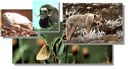
Wolves have long been a lightning rod for controversy. They evoke passionate feelings in many of us. Some people love them, a few fear them, others prefer that they be shot. On the Arctic Refuge, however, these differences are seldom voiced. Why? The wolf is wild, beautiful, and inspiring. So is the Refuge. The two belong together. People know it and expect it.

Cousin to the dog, the gray wolf is a highly social animal, preferring to live in packs. The pack, dominated by a male/female pair, may include their pups of the year, wolves born the previous year, and other adults.

Gray wolves may be shades of gray, brown, black, or white. Wolves of all these colors roam the Refuge. Some five packs totalling 25 to 30 animals live on the Refuge's north slope east of the Canning River. The wolves are found primarily in the mountains and foothills along major rivers.

The makeup of wolf packs on the Refuge's north slope varies. In summer, many wolves hunt alone or in pairs. Some are "drifters." Others may switch packs or move to new areas, perhaps following the caribou migration. In winter the packs stay together more to hunt.

Gray wolves mate in late February and March. The pairs then move to maternity dens near rivers in the foothills and mountains. About four to seven pups are born in late May or early June. The pups are weaned during the summer, and the dens are abandoned in July or August. By early winter, the pups can travel and hunt with the adult wolves.

Although to date, no dens have been found on the Refuge coastal plain, wolves make frequent trips there from May to July when the Porcupine caribou herd is present. After the caribou leave the coastal plain, the wolves stay in the mountains and foothills hunting caribou, along with Dall sheep and moose. Wolves, however, are opportunistic feeders. They will catch small rodents, birds, and ground squirrels if they can.

Natural relationships between predator and prey still prevail on the Arctic Refuge. Here the wolf's connection to the caribou and the land continues as it has for centuries. Untamed and free, the wolf is a symbol for the Refuge - a truly remarkable place.

Refuges: where wildlife comes first

Refuge Information | Wildlife | Habitat | People
Home | New | Feedback | Index | Search

Why we archived the ANWR website at Mapcruzin.com

Note: This is the MapCruzin.com archive of the FWS Arctic National Wildlife Refuge website. In December, 2001 FWS took this website offline, making it unavailable to the public. It includes 90 plus pages of information and many maps. As of 2006 the important information contained in this, the original "unsanitized" version of the FWS website, has yet to return to the internet, so we will continue to maintain it here as a permanent archive to help inform activists and concerned citizens. If you find any broken links, please report them to me at mike@learn2map.com and I will attempt to make the repairs. January, 2008 update - A small part of the original information that was present in 2001 has made it back into the current ANWR website. There is also an archive that contains a small amount of the original information, but it is not readily available from the main website.

Click here to visit our homepage. Click here for NRDC's message about ANWR from Robert Redford.

For more information on why this website was "pulled," Check here. And, you can also view the maps of caribou calving areas that the FWS did not want you to see here.

January 29, 2008: Visit Our New ANWR News for Updates


This page should be cited as follows:

U.S. Fish and Wildlife Service. 2001. Potential impacts of proposed oil and gas
       development on the Arctic Refuge’s coastal plain: Historical overview and
       issues of concern. Web page of the Arctic National Wildlife Refuge,
       Fairbanks, Alaska. 17 January 2001. http://arctic.fws.gov/issues1.html


Archived by MapCruzin.com. Visit us at www.mapcruzin.com.

MapCruzin.com is an independent firm specializing in the publication of educational and research resources. We created the first U.S. based interactive toxic chemical facility maps on the internet in 1996 and we have been online ever since. Learn more about us and view some of our projects and services.

Contact Us

Report Broken Links

Bookmark and Share

Free Shapefiles:
New Additions
FCC Wireless Licensing and Market Boundary Shapefiles, TRI National Analysis Data, Shapefiles, U.S. State ArcGIS Shapefiles, Afghanistan ArcGIS Shapefiles, Natural Disaster ArcGIS Shapefiles, Renewable Wind Energy Shapefiles, EPA Criteria Pollutant Shapefiles, North American Transportation Shapefiles, 2009 Tiger Line, State GIS, World Country ArcGIS, U.S. State GIS Resources, Climate Maps, Canada, Mexico, U.S. Transportation, ArcGIS shapefiles, Neighborhood Boundary, Satellite Aerial
Oil & Gas Field Energy, Toxic Risks, Neighborhoods & Schools, EPA Geospatial, U.S. Boundary Shapefiles, H1N1 Swine Flu, EPA TRI Toxic Release Inventory, Pollution Maps

MapCruzin Blog for updates, questions and answers

Blog Updates

More Blog Updates

Most Popular:
Renewable Energy Shapefiles, Oil & Gas Field Energy, Renewable Energy Potential Maps, Residential Energy Consumption Maps, 2009 Tiger Line Shapefiles, World Energy Maps, Haiti Earthquake Maps & Resources, Orbit Free GIS for Mac OSX, Win 32 & 64, Unix, FCC Wireless Licensing and Market Boundary Shapefiles, TRI National Analysis Data, Shapefiles, U.S. State ArcGIS Shapefiles, Afghanistan ArcGIS Shapefiles, Free GIS & Geospatial Software, Afghanistan Maps, Natural Disaster ArcGIS Shapefiles, U.S. State Maps, Satellite & Aerial Photos, Health Uninsured Maps, Climate Change, Cell Phone Health, Towers, Maps, Chemical Terrorism, Transportation Shapefiles, Toxics, Chemicals, Schools, Google Earth & Maps, Indian & Federal Lands Shapefiles, Arctic National Wildlife Refuge Maps, Economy Maps, TOPO Maps, MapCruzin Blog

Partners
Climate Shift, Recycle, Reuse & Salvage, TerraKnowledge.net, Climate Injustice, Pollution Map Projects, News & Resources, Blue Creek - Ah Pah, Right Livelihoods, Reimagination, Redwood Ecotours

Can we do a project for you?

MapCruzin Consulting
GIS and Google Maps Development, Website Creation and Hosting, Fast and Affordable.

Downloads

Google Earth Toxic Release Inventory (TRI) Maps
Lester Brown's Plan B 3.0
State GIS Shapefiles, Maps & Resources
GIS Shapefiles & Maps
GIS Programs, Tools & Resources
Free World Country & Regional Maps
GIS / GPS Careers and Job Positions
Disease Outbreak Maps
TOPO Maps
Extreme Weather & Disaster Maps
Free World Maps from the CIA Factbook
Arctic National Wildlife Refuge ANWR Maps
Oil and Gas Maps
Africanized Honey Bees
Renewable Energy Potential Maps of the United States
Terrorism Maps
War Maps
Google Maps
Weather Maps
GPS Resources
Historical Maps of the World
Google Earth
Library of Congress American Memory Map Downloads
Toxic Chemical Pollution Maps
Climate Change Maps
Toxic Release Inventory (TRI) Maps
Census Shapefiles
World Maps

Issues

Environmental Justice
Data Sources
Greenwash & JunkScience
Statistical Resources
Wireless Dangers
Surviving Climate Change
Global Right-To-Know
Creating Living Economies
Books of Note
Toxic Klamath River
Federal Lands Maps
TRI Analysis
TRI Webmaps
EnviroRisk Map Network
Community-Based Research
Right-To-Know or Left to Wonder?
Chemical Industry Archives
21st Century Warfare
Biotechnology
Nanotechnology
Globalization/Democracy
Shrubbed
National Parks and Public Lands
Trade Secrets/Toxic Deception
GIS Books
Our Projects
Other Projects
1999 Archive Environews
Environmental Books
Environmental Links
Redwood Coast Information
Recycle, Salvage, Reuse

Resources

Environmental Book Discounts
Korten - Speth - Bullard
Environmental Justice
Hawken - Climate Change
Peak Oil - Alternative
Energy - Nuclear Risk
Water Crisis - Food Crisis
Energy Crisis - Housing
Crisis

GIS Book Discounts
GIS - GPS - Remote
Sensing - Google Maps
Cartography - Geography
Maps - Google Earth

About MapCruzin - Privacy, Fair Use and Disclaimer - Advertise on MapCruzin.com

Home | Free GIS | Downloads | Parks & Public Lands | Books | Environmental Justice | News Archives
Free GIS Tutorial | Consulting | TRI 2004 MAPS | Recycle Reuse Business | Toxics Explorer
North Coast GIS | Contact/About Us | Redwood Ecotours | Global Positioning | EnviroRisk Map Network
Climate Collapse | Free GIS Tutorial | What is GIS? | Right to Know | Reimagination | Health & GIS | Shrubbed | Search

Questions, Comments or Suggestions? Contact Us

Website development and hosting provided by the Reimagination Network

Copyright © 1996 - 2010 Reimagination Network, All Rights Reserved
MapCruzin is a Pop-Up Free Website -- Best Viewed With ANY Browser