Refuge Information | Wildlife | Habitat | People
Home | New | Feedback | Index | Search
Why we archived the ANWR website at MapCruzin.com
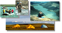
Rivers
General Information
Most refuge rivers are relatively swift with boulder-strewn or braided gravel beds,
especially on the north side. Water quality is excellent, although rivers are high and
turbid during breakup and after storms. Some rivers carry glacial silt in summer.
 Rivers must be evaluated and run
according to conditions at the time. River ratings are
subjective and can change with the stage of the river. Rivers must be evaluated and run
according to conditions at the time. River ratings are
subjective and can change with the stage of the river.
Rivers are generally open June through September, but the safest water levels occur in July
and early August. Floaters and hikers should be aware of above-average flows which can occur
any time, especially after heavy rains upstream. Low water can occur in August, but is usually
not a serious problem. It is generally possible to line through or portage around the most
difficult sections. Breakup occurs during May and early June, depending on the location.
Rivers are often at flood stage during this time with ice floes and "aufeis" that make
floating hazardous.
Aufeis are thick layers of ice formed by successive freezing of stream overflows
during winter. During breakup, rivers carve vertical walled canyons through aufeis
fields that can be more than a mile long. In early summer, it can be dangerous to
travel through these areas. By mid to late June, the channels are usually open enough to
allow passage. However, aufeis fields can be dangerous any time if river levels rise. Visitors
should scout all aufeis fields prior to floating to make sure the river is not flowing
under or through tunnels in the ice.
Canning and Marsh Fork of the Canning
The Canning is the longest north flowing river on the Refuge. Both the Canning and its major
tributary, the Marsh Fork, have good headwaters access and flow through scenic, glaciated
valleys. Through the mountains, the Canning has a mostly flat, steady current. The Marsh Fork
has short stretches of whitewater. About 15 miles before it empties into the Beaufort Sea, the
Canning becomes very braided, widening to three miles near the coast.
Coleen
This clear and shallow river flows south through scenic country on the east side of
the Refuge. Its upper reaches are braided and have poor access. Although its forested
middle and lower sections have good access, the Coleen is one of the refuge's less floated
rivers.
East Fork of the Chandalar
From its high mountainous headwaters, this river flows swiftly south through a wide,
mountain-rimmed valley, then meanders through a forested, lake-dotted area. The river flows
past Arctic Village and is a highway to subsistence hunting, fishing and trapping areas.
Hulahula
Beginning in the highest peaks of
the Brooks Range, this river flows north through
steep-walled glacial valleys, then winds through the coastal plain to the Beaufort Sea.
Due to its scenery and access, the Hulahula is the second most floated river on the Refuge.
Swift and turbid with glacial silt, it also is the most challenging of the regularly run north
slope rivers. At average flow rates, waters are generally class I and II, but there are
stretches of class III. A narrow pass across the continental divide between the headwaters
of the Hulahula and Chandalar Rivers provides a natural hiking route and a frequently used
corridor for aircraft.
Ivishak
A designated Wild river, the Ivishak flows north some 60 miles from the Philip Smith
mountains. Fed by relic hanging glaciers, the Ivishak develops a broad, braided flood
plain typical of other north slope rivers on the Refuge. Although the river is scenic,
its shallow water, poorly defined channel and marginal access result in low use by floaters.
Kongakut
This is the only major river whose entire course is within the refuge's designated
wilderness. Beginning high in the eastern Brooks Range, the Kongakut flows east and then
north through rugged mountains to the coastal plain and the Beaufort Sea. Clear water,
scenery, wildlife, fishing and access combine to make the Kongakut the most floated river
on the Refuge. At average flow rates, its waters are generally class I and II, but there
are stretches of class III.
Okpilak
The silt-laden Okpilak begins in the heart of the most active glacial area of the
Refuge. The river flows north through a classic U-shaped valley containing moraines, fans,
sand dunes and other glacial features. The upper river is too dangerous for river floating
and there is no aircraft access, but the area offers hikers an uncommonly tranquil and scenic
experience.
Porcupine
The Porcupine is one of the largest tributaries of the Yukon River and a historically
important travel route. Single-channeled and clear-flowing, this mostly flatwater
river flows through the Refuge past beautiful steep-walled canyons, rolling hills and
cliffs before meandering across the vast wetland basin of the Yukon Flats.
Sheenjek
This glacial-fed river drains the south side of the Brooks Range's highest mountains.
A designated Wild river, the Sheenjek flows through dramatic mountains and forested
foothills to join the Porcupine River in the Yukon Flats National Wildlife Refuge.
Single-channeled with numerous access sites, the Sheenjek is the most popular of the
refuge's south-flowing rivers. Most of the river is class I but there are short sections
of class II.
Wind
This designated Wild river begins across the divide from the headwaters of the Ivishak
and flows southeast to join the East Fork Chandalar. Open tundra valleys fringed by limestone
and shale mountains characterize its upper reaches while forested hills, lakes and meadows
dominate the lower river. The Wind is seldom floated due to its normally shallow water.
Other rivers
The Aichilik, Egaksrak, Firth, Jago, Katakturuk, Sadlerochit, Tamayariak and Junjik
rivers are scenic and have good wildlife viewing, but they are not generally good for
floating due to low water levels, extensive braiding and/or lack of good aircraft access.

Refuge Information | Wildlife | Habitat | People
Home | New | Feedback | Index | Search
Text and graphics by USFWS staff
Last modified 28 July 2000
Why we archived the ANWR website at Mapcruzin.com
Note: This is the MapCruzin.com archive of the FWS Arctic National Wildlife Refuge website. In December, 2001 FWS took this website offline, making it unavailable to the public. It includes 90 plus pages of information and many maps. As of 2006 the important information contained in this, the original "unsanitized" version of the FWS website, has yet to return to the internet, so we will continue to maintain it here as a permanent archive to help inform activists and concerned citizens. If you find any broken links, please report them to me at [email protected] and I will attempt to make the repairs. January, 2008 update - A small part of the original information that was present in 2001 has made it back into the current ANWR website. There is also an archive that contains a small amount of the original information, but it is not readily available from the main website.
Click here to visit our homepage. Click here for NRDC's message about ANWR from Robert Redford.
For more information on why this website was "pulled," Check here. And, you can also view the maps of caribou calving areas that the FWS did not want you to see here.
 January 29, 2008: Visit Our New ANWR News for Updates January 29, 2008: Visit Our New ANWR News for Updates
This page should be cited as follows:
U.S. Fish and Wildlife Service. 2001. Potential impacts of proposed oil and gas
development on the Arctic Refuge�s
coastal plain: Historical overview and
issues of concern. Web page of the Arctic National
Wildlife Refuge,
Fairbanks, Alaska.
17 January 2001. http://arctic.fws.gov/issues1.html
Archived by MapCruzin.com. Visit us at mapcruzin.com.
MapCruzin.com is an independent firm
specializing in the publication of
educational and research resources.
We created the first U.S. based
interactive toxic chemical facility
maps on the internet in 1996 and we
have been online ever since. Learn more about us and view some of our projects and services.
Contact Us
Report Broken Links
| 


