GIS Shapefile Store - for Beginners & Experienced GIS Users Alike. Geographic Names Information System, Nuclear Facilities, Zip Code Boundaries, School Districts, Indian & Federal Lands, Climate Change, Tornadoes, Dams - Create digital GIS maps in minutes.
[This information was originally produced by Beverly Skinner, wildlife biologist at Innoko
National Wildlife Refuge (in west central Alaska), for radio broadcast on Public Radio stations
throughout Alaska.]
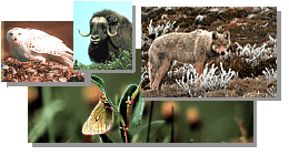
One striking bird interior Alaskan residents should begin seeing in early spring is the bald
eagle. Courting eagles are commonly seen chasing each other and swooping down sometimes
with locked talons. It is hard to believe but many of the raptors or birds of prey such as the bald
eagle are already beginning their breeding and nesting period. Early April is the typical time
mature eagles begin nesting in interior Alaska.
With their conspicuous white head and tail, which they acquire at about 5 years of age, bald
eagles are pretty distinct looking. Only the young brown and mottled birds under 3 to 4 years of
age are hard to tell apart from our other interior eagle - the golden eagle. The bald eagle is
Alaska's largest resident bird. Their wing span can reach up to 8 feet and they weigh between 10
and 14 pounds. Like most raptors, female bald eagles are bigger than the males.
The bald eagle was adopted as our national emblem in 1782 mainly because people at that
time thought they were fierce looking. In reality, bald eagles are actually quite timid, are easily
disturbed and spend most of their time looking for carrion or dead salmon and animals to eat.
Only when they can't find their preferred food, dead or dying fish, will they hunt for themselves.
At one time Alaska had a bounty on eagles because fox farmers and fishermen thought the
birds were killing too many foxes and fish. It took over 40 years before these claims were
scientifically proven false and the bounty was removed in 1953. Meanwhile over 100,000 eagles
were killed here in Alaska. Bald eagles numbers in Alaska have since recovered and are now felt
to be at about the same level as before the bounty. Bald eagles are now protected under the Bald
Eagle Protection Act and the Migratory Bird Treaty Act.
Bald eagles mate for life. They pick nesting sites that have early spring food available and
will return to the same nest year after year. In interior Alaska, bald eagles usually nest in tall
trees or on cliffs. While cliff nests can be made up of a few sticks, tree nests are composed of
large sticks and are lined with soft materials. The nesting trees are usually the tallest tree in the
area and since bald eagles continue to add nesting material each year to their nests, the tree limbs
must be strong enough to hold large heavy nests.
For Alaska Naturally and the Innoko NWR, this is Beverly Skinner. Pesticides showing up
in returning Alaskan salmon may become tomorrow's threat against our Bald eagles. But a more
immediate threat is loss of nesting habitat by logging. In interior Alaska, bald eagles nest
primarily in old growth timber along mainland rivers. By leaving buffer areas of uncut trees
approximately 1/4 to 1/2 mile around Bald eagle nests, both loggers and bald eagles
can coexist.
Note: This is the MapCruzin.com archive of the FWS Arctic National Wildlife Refuge website. In December, 2001 FWS took this website offline, making it unavailable to the public. It includes 90 plus pages of information and many maps. As of 2006 the important information contained in this, the original "unsanitized" version of the FWS website, has yet to return to the internet, so we will continue to maintain it here as a permanent archive to help inform activists and concerned citizens. If you find any broken links, please report them to me at [email protected] and I will attempt to make the repairs. January, 2008 update - A small part of the original information that was present in 2001 has made it back into the current ANWR website. There is also an archive that contains a small amount of the original information, but it is not readily available from the main website.
Click here to visit our homepage. Click here for NRDC's message about ANWR from Robert Redford.
U.S. Fish and Wildlife Service. 2001. Potential impacts of proposed oil and gas
development on the Arctic Refuge�s
coastal plain: Historical overview and
issues of concern. Web page of the Arctic National
Wildlife Refuge,
Fairbanks, Alaska.
17 January 2001. http://arctic.fws.gov/issues1.html
Archived by MapCruzin.com. Visit us at mapcruzin.com.
MapCruzin.com is an independent firm
specializing in the publication of
educational and research resources.
We created the first U.S. based
interactive toxic chemical facility
maps on the internet in 1996 and we
have been online ever since. Learn more about us and view some of our projects and services.


 January 29, 2008: