Refuge Information | Wildlife | Habitat | People
Home | New | Feedback | Index | Search
Why we archived the ANWR website at MapCruzin.com
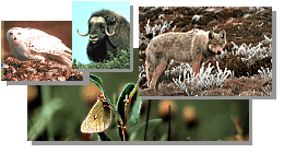
ANWR Bears
Topics on this page:
Polar Bears
Brown Bears
Polar Bears
 It's a
magnificent, powerful, and fearless animal; the world's largest land carnivore. The
polar bear is a unique part of our natural heritage - directly connected to the Arctic Refuge.
How? Every year, several of these impressive animals come to the Refuge to den and give birth.
Many others congregate along the coast of the Refuge in October and November. It's a
magnificent, powerful, and fearless animal; the world's largest land carnivore. The
polar bear is a unique part of our natural heritage - directly connected to the Arctic Refuge.
How? Every year, several of these impressive animals come to the Refuge to den and give birth.
Many others congregate along the coast of the Refuge in October and November.
These bears are part of the Beaufort Sea population, estimated at 2,000 animals. They use an
area extending more than 800 miles along the north coasts of Alaska and Canada. The bears
spend most of their time on the drifting pack ice, feeding, resting, and denning. Each year,
however, many of the pregnant females come to shore to dig maternity dens in snow drifts.
The pregnant females move onshore in late fall. When and where they go depends on
weather, formation of sea ice, and snowdrift patterns. The pregnant bears dig their dens in
November, then give birth to one or two tiny cubs in December or January. The mothers nurse
and care for the young until March or early April, when they emerge from the dens. After
several
days getting used to the outside environment, including short trips to strengthen the cubs, the
families leave the dens. They move back to the sea ice to hunt ringed seals and other prey. The
cubs stay with their mothers, learning to hunt, for about the next two and a half years.
Along Alaska's coast, the highest density of polar bear land dens occurs within the Refuge.
Many more dens have been found here than would be expected if bears denned uniformly along
the coast. One reason may be that the Refuge coastal plain and northern foothills have more
uneven terrain than areas to the west, allowing snow drifts to form more readily. Within the
Refuge, bears have denned in the Canning River Delta, Camden Bay area, and Pokok Lagoon
bluffs.
The Arctic Refuge is the only national conservation area where polar bears regularly den and
the most consistently used polar bear land denning area in Alaska. These are just two of many
reasons the Refuge is such an incredible natural area.
Return to Top
Brown Bears
Brown bears are the undisputed monarchs of the open tundra and mountains of Alaska. On
the Arctic Refuge, they live farther north than any others of their species. Also called grizzlies
because of the "grizzled" blond tips of their fur, brown bears can be shades of cream, brown, or
black.
Brown bears escape the Refuge's long winters by hibernating for up to eight months each
year. During this long sleep, bears do not eat or drink. They do, however, give birth and nurse
their cubs.
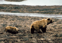 Outside
the den, brown bears explore widely for foods that are often in short supply. While
spring snows remain, bears eat carrion, ground squirrels, and roots. In early June, some bears,
especially sows with young, prey on newborn caribou. This opportunity lasts only a few weeks,
until the calves are too nimble to catch. During the summer, brown bears feed mainly on greens.
Some search high into the mountains for new growth emerging from late-melting snows. Later,
the bears consume large quantities of berries. When snows return, often by mid-September, the
bears again dig for ground squirrels and roots. Outside
the den, brown bears explore widely for foods that are often in short supply. While
spring snows remain, bears eat carrion, ground squirrels, and roots. In early June, some bears,
especially sows with young, prey on newborn caribou. This opportunity lasts only a few weeks,
until the calves are too nimble to catch. During the summer, brown bears feed mainly on greens.
Some search high into the mountains for new growth emerging from late-melting snows. Later,
the bears consume large quantities of berries. When snows return, often by mid-September, the
bears again dig for ground squirrels and roots.
Most Refuge brown bears den in the mountains south of the coastal plain. Because the
Refuge is underlain by permanently frozen ground, bears select rock caves, or sandy soils that
have thawed more than four feet deep. The soils can collapse easily unless the top four inches
are frozen, so bears must wait, usually until mid-October, for a hard freeze before excavating
their dens.
Brown bears on the Refuge are faced with a long winter hibernation and limited food
resources. As a result, they have small bodies, low reproduction rates, and slowly maturing
young. This northernmost population has remained remarkably stable, however. The only
enemies these monarchs have are old age, other brown bears, and occasionally man.
Brown bears are plentiful on the Refuge. Listening at night through paper-thin tent walls,
walking through dense willows, or cresting a hilltop - the possibility of meeting a bear heightens
our senses. Without these magnificent animals, the special wilderness quality of the Arctic
Refuge would be greatly diminished.
Return to Top

Refuge Information | Wildlife | Habitat | People
Home | New | Feedback | Index | Search
Why we archived the ANWR website at Mapcruzin.com
Note: This is the MapCruzin.com archive of the FWS Arctic National Wildlife Refuge website. In December, 2001 FWS took this website offline, making it unavailable to the public. It includes 90 plus pages of information and many maps. As of 2006 the important information contained in this, the original "unsanitized" version of the FWS website, has yet to return to the internet, so we will continue to maintain it here as a permanent archive to help inform activists and concerned citizens. If you find any broken links, please report them to me at [email protected] and I will attempt to make the repairs. January, 2008 update - A small part of the original information that was present in 2001 has made it back into the current ANWR website. There is also an archive that contains a small amount of the original information, but it is not readily available from the main website.
Click here to visit our homepage. Click here for NRDC's message about ANWR from Robert Redford.
For more information on why this website was "pulled," Check here. And, you can also view the maps of caribou calving areas that the FWS did not want you to see here.
 January 29, 2008: Visit Our New ANWR News for Updates January 29, 2008: Visit Our New ANWR News for Updates
This page should be cited as follows:
U.S. Fish and Wildlife Service. 2001. Potential impacts of proposed oil and gas
development on the Arctic Refuge�s
coastal plain: Historical overview and
issues of concern. Web page of the Arctic National
Wildlife Refuge,
Fairbanks, Alaska.
17 January 2001. http://arctic.fws.gov/issues1.html
Archived by MapCruzin.com. Visit us at mapcruzin.com.
MapCruzin.com is an independent firm
specializing in the publication of
educational and research resources.
We created the first U.S. based
interactive toxic chemical facility
maps on the internet in 1996 and we
have been online ever since. Learn more about us and view some of our projects and services.
Contact Us
Report Broken Links
| 


